Таннерон (Tanneron, Tanneron)

- коммуна во Франции
 Hiking in Таннерон
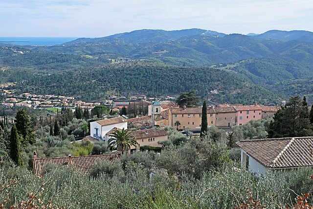
Tanneron is a picturesque village located in the Alpes-Maritimes department in the Provence-Alpes-Côte d'Azur region of southeastern France. Known for its stunning natural landscapes, the area offers a variety of hiking opportunities that cater to different experience levels.
Key Highlights for Hiking in Tanneron:
-
Scenic Trails: The region is characterized by its diverse terrain, including hills, forests, and panoramic views of the Mediterranean coast. The trails are often lined with beautiful wildflowers, especially during spring.
-
Le Tanneron Nature Reserve: This area features several hiking paths that meander through the natural reserve, showcasing the rich flora and fauna. It's ideal for nature lovers looking to spot local wildlife or simply enjoy the tranquility of the surroundings.
-
Panoramic Views: Many trails in Tanneron provide breathtaking vistas of the surrounding countryside, the Var valley, and sometimes even glimpses of the distant Mediterranean Sea. The summit of Mount Tanneron is particularly rewarding for those seeking expansive views.
-
Trail Options:
- Easy to Moderate Hikes: Numerous well-marked paths offer a comfortable hiking experience suitable for families and beginner hikers.
- Challenging Routes: For more experienced hikers, there are steep paths that lead to higher elevations, rewarding those who take on the challenge with remarkable views.
-
Seasonal Considerations: Spring and early fall are ideal times to hike in Tanneron due to milder temperatures and the stunning scenery, but summer can also be enjoyable if you start early in the day to avoid the heat.
-
Local Attractions: After a day of hiking, you can explore the charming village of Tanneron, enjoy local cuisine, or visit nearby attractions such as the flower fields that are famous in the area.
-
Preparation Tips:
- Bring plenty of water, especially in warmer months.
- Wear sturdy hiking shoes and sun protection.
- Check weather conditions before your hike, and be prepared for changing weather.
-
Directions and Accessibility: Tanneron is accessible by car, and there are parking areas near popular trailheads. Public transport options may be limited, so planning your trip in advance is advisable.
Overall, hiking in Tanneron offers a lovely combination of natural beauty, tranquility, and a taste of local culture, making it a wonderful destination for outdoor enthusiasts.
- Страна:

- Почтовый код: 83440
- Координаты: 43° 35' 26" N, 6° 52' 32" E


- GPS треки (wikiloc): [Ссылка]
- Площадь: 52.78 кв.км
- Население: 1572
- Википедия русская: wiki(ru)
- Википедия английская: wiki(en)
- Википедия национальная: wiki(fr)
- Хранилище Wikidata: Wikidata: Q818113
- Катеория в википедии: [Ссылка]
- код Freebase: [/m/03x_wvf]
- код GeoNames: Альт: [6618464]
- номер SIREN: [218301331]
- код BNF: [15277960p]
- код муниципалитета INSEE: 83133
Граничит с регионами:


Фрежюс
- коммуна во Франции
- Страна:
- Почтовый код: 83600
- Координаты: 43° 25' 59" N, 6° 44' 8" E
- GPS треки (wikiloc): [Ссылка]
- Площадь: 102.27 кв.км
- Население: 52897
- Веб сайт: [Ссылка]


Мандельё-ла-Напуль
- коммуна в департаменте Приморские Альпы, регион Прованс — Альпы — Лазурный Берег, Франция
- Страна:
- Почтовый код: 06210
- Координаты: 43° 32' 44" N, 6° 56' 15" E
- GPS треки (wikiloc): [Ссылка]
- Высота над уровнем моря: 300 м m
- Площадь: 31.37 кв.км
- Население: 22360
- Веб сайт: [Ссылка]

Пегома
- коммуна в департаменте Приморские Альпы, регион Прованс — Альпы — Лазурный Берег, Франция
Hiking in Пегома
Pégomas, a quaint commune located in the Alpes-Maritimes department in the French Riviera, offers a range of hiking opportunities that showcase its beautiful natural surroundings. Here are some key points to consider when hiking in the Pégomas area:...
- Страна:
- Почтовый код: 06580
- Координаты: 43° 35' 48" N, 6° 56' 0" E
- GPS треки (wikiloc): [Ссылка]
- Площадь: 11.28 кв.км
- Население: 7845
- Веб сайт: [Ссылка]


Орибо-сюр-Сьянь
- коммуна в департаменте Приморские Альпы, регион Прованс — Альпы — Лазурный Берег, Франция
Hiking in Орибо-сюр-Сьянь
Auribeau-sur-Siagne is a picturesque village located in the Alpes-Maritimes region of France, near the French Riviera. It's nestled in the hills and offers a variety of hiking opportunities that showcase its natural beauty and the surrounding landscape....
- Страна:
- Почтовый код: 06810
- Координаты: 43° 36' 3" N, 6° 54' 40" E
- GPS треки (wikiloc): [Ссылка]
- Площадь: 5.48 кв.км
- Население: 3219
- Веб сайт: [Ссылка]

Пейменад
- коммуна в департаменте Приморские Альпы, регион Прованс — Альпы — Лазурный Берег, Франция
Hiking in Пейменад
Peymeinade, a charming village located in the Alpes-Maritimes region of France, is an excellent starting point for hiking enthusiasts. Nestled in the foothills of the picturesque Provencal countryside, it offers a variety of trails that cater to all skill levels....
- Страна:
- Почтовый код: 06530
- Координаты: 43° 38' 32" N, 6° 52' 33" E
- GPS треки (wikiloc): [Ссылка]
- Площадь: 9.76 кв.км
- Население: 8116
- Веб сайт: [Ссылка]


Лез-Адре-де-л’Эстерель
- коммуна во Франции
- Страна:
- Почтовый код: 83600
- Координаты: 43° 31' 32" N, 6° 48' 51" E
- GPS треки (wikiloc): [Ссылка]
- Площадь: 22.26 кв.км
- Население: 2741
- Веб сайт: [Ссылка]


Монтору
- коммуна во Франции
Hiking in Монтору
Montauroux, located in the Var department of the Provence-Alpes-Côte d'Azur region in southeastern France, offers a stunning backdrop for hikers with its picturesque landscapes, charming villages, and proximity to the beautiful French Riviera. Here are some highlights about hiking in Montauroux:...
- Страна:
- Почтовый код: 83440
- Координаты: 43° 37' 6" N, 6° 45' 55" E
- GPS треки (wikiloc): [Ссылка]
- Площадь: 33.54 кв.км
- Население: 6298

Ле-Тинье
- коммуна в департаменте Приморские Альпы, регион Прованс — Альпы — Лазурный Берег, Франция
Hiking in Ле-Тинье
Le Tignet is a charming village located in the Alpes-Maritimes region of France, not far from the French Riviera. It's known for its beautiful landscapes, picturesque views, and proximity to the Verdon Gorge and the hills of the Provence hinterlands. Here are some key aspects of hiking in this area:...
- Страна:
- Почтовый код: 06530
- Координаты: 43° 37' 45" N, 6° 50' 37" E
- GPS треки (wikiloc): [Ссылка]
- Площадь: 11.26 кв.км
- Население: 3311