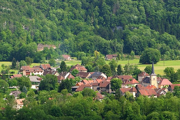
Лез-Эшель (Les Échelles, Les Échelles)

- коммуна во Франции
 Hiking in Лез-Эшель
Les Échelles, located in the Savoie department of the Auvergne-Rhône-Alpes region in southeastern France, is an excellent destination for hiking enthusiasts. This picturesque area is characterized by stunning mountain landscapes, limestone cliffs, and breathtaking views, making it ideal for both novice and experienced hikers.
Hiking Routes and Trails
-
Les Échelles Pathways: The region features well-marked hiking trails that lead through lush forests, rocky terrains, and offer panoramic views of the surrounding mountains. One of the more popular routes is the Gorges de Chailles, which provides a spectacular trek alongside a river.
-
Col de Tamié: This is a more strenuous hike but rewards you with incredible vistas and a chance to see local wildlife, such as deer and various bird species.
-
Cascades de l'Oule: This trail leads hikers to beautiful waterfalls, making it a refreshing hike, especially in the warmer months. The sound of cascading water adds to the serene experience.
-
Vercors Regional Natural Park: Just a short distance away, this park offers numerous trails that can be accessed from Les Échelles. The Vercors is known for its breathtaking scenery and diverse flora and fauna.
What to Expect
- Scenery: The area is rich in natural beauty, with picturesque valleys, dramatic cliffs, and views of the Chartreuse and Belledonne mountain ranges.
- Wildlife: Hikers may encounter a variety of fauna, including chamois, marmots, and numerous bird species, particularly in the regions of the national parks.
- Seasonal Considerations: The best times for hiking in Les Échelles are late spring through early autumn. Winters can bring snow to the trails, which can limit access or require specialized gear.
Tips for Hiking in Les Échelles
- Gear Up: Ensure you have suitable footwear and clothing. The weather can change quickly in the mountains, so layering is essential.
- Stay Hydrated: Bring plenty of water, especially during the warmer months.
- Map and Compass: Always carry a map or download offline maps on your device, as some areas may have limited cell service.
- Local Regulations: Respect local wildlife and follow trail guidelines. Some areas may have restrictions to protect natural habitats.
Getting There
Les Échelles is accessible by car from major cities in the region, such as Grenoble and Chambéry. There are also public transport options, including buses and regional trains that can take you close to the hiking areas.
In summary, hiking in Les Échelles offers a combination of stunning natural beauty, diverse trails, and a peaceful outdoor experience. Whether you're seeking a challenging hike or a leisurely stroll, this region has something for everyone.
- Страна:

- Почтовый код: 73360
- Координаты: 45° 26' 12" N, 5° 45' 14" E


- GPS треки (wikiloc): [Ссылка]
- Площадь: 3.75 кв.км
- Население: 1206
- Википедия английская: wiki(en)
- Википедия национальная: wiki(fr)
- Хранилище Wikidata: Wikidata: Q538131
- Катеория в википедии: [Ссылка]
- код Freebase: [/m/03qlmch]
- код GeoNames: Альт: [6615115]
- номер SIREN: [217301050]
- код BNF: [15274039n]
- код VIAF: Альт: [244359611]
- код GND: Альт: [7757013-3]
- WOEID: [606091]
- код муниципалитета INSEE: 73105
Граничит с регионами:

Сен-Кристоф-сюр-Гьер
- коммуна во Франции
Hiking in Сен-Кристоф-сюр-Гьер
Saint-Christophe-sur-Guiers is a charming village located in the Isère department of the Auvergne-Rhône-Alpes region in southeastern France. The area is surrounded by stunning natural landscapes, making it a great destination for hiking enthusiasts....
- Страна:
- Почтовый код: 38380
- Координаты: 45° 26' 19" N, 5° 46' 26" E
- GPS треки (wikiloc): [Ссылка]
- Площадь: 23.54 кв.км
- Население: 858
- Веб сайт: [Ссылка]


Антр-дё-Гье
- коммуна во Франции
Hiking in Антр-дё-Гье
Entre-deux-Guiers, located in the Isère department of the Auvergne-Rhône-Alpes region in France, is a fantastic hiking destination. The area is known for its beautiful landscapes, characterized by beautiful mountains, lush valleys, and varied terrain. Here are some highlights for hiking in this region:...
- Страна:
- Почтовый код: 38380
- Координаты: 45° 25' 56" N, 5° 45' 0" E
- GPS треки (wikiloc): [Ссылка]
- Площадь: 10.55 кв.км
- Население: 1699
- Веб сайт: [Ссылка]


Мирибель-лез-Эшель
- коммуна во Франции
Hiking in Мирибель-лез-Эшель
Miribel-les-Échelles is a charming village located in the Isère department of the Auvergne-Rhône-Alpes region in southeastern France. It is nestled in the foothills of the Chartreuse Mountains, providing a stunning backdrop for various outdoor activities, including hiking....
- Страна:
- Почтовый код: 38380
- Координаты: 45° 25' 45" N, 5° 42' 30" E
- GPS треки (wikiloc): [Ссылка]
- Площадь: 29.34 кв.км
- Население: 1720

Saint-Franc
- коммуна во Франции
Hiking in Saint-Franc
Saint-Franc, often referred to in the context of Saint-François, is a scenic region located in Guadeloupe, known for its beautiful landscapes and diverse hiking opportunities. When hiking in this area, you can expect a mix of coastal and inland trails offering stunning views, lush vegetation, and unique wildlife....
- Страна:
- Почтовый код: 73360
- Координаты: 45° 29' 29" N, 5° 44' 46" E
- GPS треки (wikiloc): [Ссылка]
- Площадь: 7.25 кв.км
- Население: 166


Saint-Christophe
Hiking in Saint-Christophe
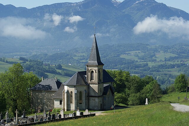
Saint-Christophe in Savoie is a beautiful destination for hiking enthusiasts. Nestled in the French Alps, this area offers stunning landscapes, including mountains, forests, and alpine meadows. Here’s what you can expect when hiking in Saint-Christophe:...
- Страна:
- Почтовый код: 73360
- Координаты: 45° 27' 2" N, 5° 46' 32" E
- GPS треки (wikiloc): [Ссылка]
- Площадь: 11.01 кв.км
- Население: 529
- Веб сайт: [Ссылка]
Saint-Pierre-de-Genebroz
- коммуна во Франции
Hiking in Saint-Pierre-de-Genebroz
Saint-Pierre-de-Genebroz is a charming commune located in the Auvergne-Rhône-Alpes region of France. It is surrounded by picturesque landscapes, making it a great spot for hiking enthusiasts. Here are some insights into hiking in and around Saint-Pierre-de-Genebroz:...
- Страна:
- Почтовый код: 73360
- Координаты: 45° 27' 10" N, 5° 45' 14" E
- GPS треки (wikiloc): [Ссылка]
- Площадь: 6.14 кв.км
- Население: 343