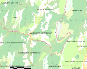
canton of Échelles (canton des Échelles)
 Hiking in canton of Échelles
Canton des Échelles, located in the Auvergne-Rhône-Alpes region of France, offers some fantastic hiking opportunities amid stunning landscapes, including mountains, forests, and rivers. Here are some highlights and tips for hiking in this area:
Trail Options:
-
Les Échelles Trails: This area has a network of marked trails ranging in difficulty from easy walks to challenging hikes. Popular trails often include those that lead to stunning viewpoints or historical sites.
-
Dents de Lanfon: A moderately difficult hike that provides breathtaking views of the surrounding Alps. The ascents can be steep, so it's recommended for hikers with some experience.
-
Belvédère de la Roche: A shorter, family-friendly hike that rewards you with panoramic views over the valley. This path is characterized by its gentle slopes, making it suitable for all ages.
Important Considerations:
-
Seasonality: Spring and autumn are ideal for hiking, with pleasant temperatures and beautiful foliage. Summer can be crowded, and winter may present challenges depending on snow and trail conditions.
-
Gear: Ensure you have appropriate hiking boots, weather-appropriate clothing, and plenty of water. Trekking poles can also be beneficial on steeper trails.
-
Navigation: Many trails are well-marked, but having a map or a GPS device is advisable. Check local resources for trail conditions before heading out.
-
Wildlife: Be aware that this area is home to diverse flora and fauna, including potential encounters with local wildlife. Familiarize yourself with proper wildlife etiquette to ensure a safe experience.
Additional Activities:
In addition to hiking, the Canton des Échelles can offer opportunities for rock climbing, mountain biking, and observing local wildlife. Be sure to explore nearby attractions as well, such as charming villages and historical sites.
Always check local guidelines and conditions before your hike, and consider informing someone of your plans if you're heading out on less-frequented trails. Enjoy your adventure in the beautiful Canton des Échelles!
- Страна:

- Столица: Лез-Эшель
- Координаты: 45° 27' 45" N, 5° 48' 2" E


- GPS треки (wikiloc): [Ссылка]
- Хранилище Wikidata: Wikidata: Q1725891
- код кантона INSEE: [7314]
Включает регионы:


Saint-Thibaud-de-Couz
- коммуна во Франции
Hiking in Saint-Thibaud-de-Couz
Saint-Thibaud-de-Couz is a charming commune located in the Savoie department of the Auvergne-Rhône-Alpes region in southeastern France. It is surrounded by the breathtaking natural beauty of the Alps, making it an excellent destination for hiking enthusiasts. Here are some highlights to consider when planning a hiking adventure in and around Saint-Thibaud-de-Couz:...
- Страна:
- Почтовый код: 73160
- Координаты: 45° 30' 4" N, 5° 50' 40" E
- GPS треки (wikiloc): [Ссылка]
- Площадь: 24.17 кв.км
- Население: 1041

Сен-Пьер-д’Антремон (Савойя)
Hiking in Сен-Пьер-д’Антремон (Савойя)
Saint-Pierre-d'Entremont, located in the Savoie region of the French Alps, offers a wealth of hiking opportunities amidst stunning natural scenery. The area is nestled between majestic mountains and lush green valleys, making it an ideal destination for nature lovers and outdoor enthusiasts....
- Страна:
- Почтовый код: 73670
- Координаты: 45° 25' 2" N, 5° 51' 15" E
- GPS треки (wikiloc): [Ссылка]
- Площадь: 18.36 кв.км
- Население: 426

Saint-Franc
- коммуна во Франции
Hiking in Saint-Franc
Saint-Franc, often referred to in the context of Saint-François, is a scenic region located in Guadeloupe, known for its beautiful landscapes and diverse hiking opportunities. When hiking in this area, you can expect a mix of coastal and inland trails offering stunning views, lush vegetation, and unique wildlife....
- Страна:
- Почтовый код: 73360
- Координаты: 45° 29' 29" N, 5° 44' 46" E
- GPS треки (wikiloc): [Ссылка]
- Площадь: 7.25 кв.км
- Население: 166


Saint-Christophe
Hiking in Saint-Christophe
Saint-Christophe in Savoie is a beautiful destination for hiking enthusiasts. Nestled in the French Alps, this area offers stunning landscapes, including mountains, forests, and alpine meadows. Here’s what you can expect when hiking in Saint-Christophe:...
- Страна:
- Почтовый код: 73360
- Координаты: 45° 27' 2" N, 5° 46' 32" E
- GPS треки (wikiloc): [Ссылка]
- Площадь: 11.01 кв.км
- Население: 529
- Веб сайт: [Ссылка]


Attignat-Oncin
- коммуна во Франции
Hiking in Attignat-Oncin
Attignat-Oncin is a lovely commune in the Auvergne-Rhône-Alpes region of France, nestled at the foothills of the French Alps. It offers a range of hiking opportunities that cater to various skill levels, making it an ideal destination for nature lovers and outdoor enthusiasts....
- Страна:
- Почтовый код: 73610
- Координаты: 45° 30' 30" N, 5° 46' 33" E
- GPS треки (wikiloc): [Ссылка]
- Площадь: 18.46 кв.км
- Население: 527


Saint-Jean-de-Couz
- коммуна во Франции
Hiking in Saint-Jean-de-Couz
Saint-Jean-de-Couz is a charming commune located in the Savoie department of the Auvergne-Rhône-Alpes region in southeastern France. It's nestled at the foot of the Alps, making it an excellent destination for hiking enthusiasts, particularly those who are looking to explore the beautiful landscapes of the French Alps....
- Страна:
- Почтовый код: 73160
- Координаты: 45° 28' 2" N, 5° 49' 6" E
- GPS треки (wikiloc): [Ссылка]
- Площадь: 7.71 кв.км
- Население: 286


Лез-Эшель
- коммуна во Франции
Hiking in Лез-Эшель
Les Échelles, located in the Savoie department of the Auvergne-Rhône-Alpes region in southeastern France, is an excellent destination for hiking enthusiasts. This picturesque area is characterized by stunning mountain landscapes, limestone cliffs, and breathtaking views, making it ideal for both novice and experienced hikers....
- Страна:
- Почтовый код: 73360
- Координаты: 45° 26' 12" N, 5° 45' 14" E
- GPS треки (wikiloc): [Ссылка]
- Площадь: 3.75 кв.км
- Население: 1206


Entremont-le-Vieux
- коммуна во Франции
Hiking in Entremont-le-Vieux
Entremont-le-Vieux is a charming commune located in the Savoie region of the French Alps, known for its stunning natural surroundings and outdoor recreational opportunities, including hiking. The area offers a variety of trails suitable for different skill levels, making it an excellent destination for hikers of all backgrounds....
- Страна:
- Почтовый код: 73670
- Координаты: 45° 27' 7" N, 5° 53' 3" E
- GPS треки (wikiloc): [Ссылка]
- Площадь: 33.01 кв.км
- Население: 654


Corbel, Savoie
- коммуна во Франции
Hiking in Corbel, Savoie
Corbel is a small commune located in the Savoie department of the Auvergne-Rhône-Alpes region in southeastern France. Nestled in the charming French Alps, Corbel offers a picturesque setting for hiking enthusiasts, featuring stunning mountain landscapes, dense forests, and beautiful alpine meadows....
- Страна:
- Почтовый код: 73160
- Координаты: 45° 25' 46" N, 5° 49' 31" E
- GPS треки (wikiloc): [Ссылка]
- Площадь: 10.31 кв.км
- Население: 157
- Веб сайт: [Ссылка]
Saint-Pierre-de-Genebroz
- коммуна во Франции
Hiking in Saint-Pierre-de-Genebroz
Saint-Pierre-de-Genebroz is a charming commune located in the Auvergne-Rhône-Alpes region of France. It is surrounded by picturesque landscapes, making it a great spot for hiking enthusiasts. Here are some insights into hiking in and around Saint-Pierre-de-Genebroz:...
- Страна:
- Почтовый код: 73360
- Координаты: 45° 27' 10" N, 5° 45' 14" E
- GPS треки (wikiloc): [Ссылка]
- Площадь: 6.14 кв.км
- Население: 343


La Bauche
- коммуна во Франции
Hiking in La Bauche
La Bauche, located in the Auvergne-Rhône-Alpes region of France, offers a variety of hiking opportunities that showcase the beautiful landscapes and unique geology of the area. While it may not be as well-known as some of the larger alpine areas, it has its own charm....
- Страна:
- Почтовый код: 73360
- Координаты: 45° 28' 57" N, 5° 45' 54" E
- GPS треки (wikiloc): [Ссылка]
- Площадь: 6.58 кв.км
- Население: 512