Les Allues (Les Allues)

- коммуна во Франции
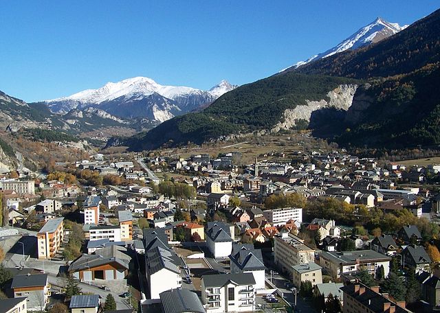
 Hiking in Les Allues
Les Allues is a charming village located in the French Alps, near the popular ski resort of Méribel in the Tarentaise Valley. While it is best known for its winter sports, Les Allues also offers beautiful hiking opportunities during the warmer months.
Hiking Opportunities:
-
Scenic Trails: The area around Les Allues boasts numerous scenic hiking trails that vary in difficulty, making it suitable for both beginners and experienced hikers. You can enjoy stunning views of the mountains, lush valleys, and the surrounding alpine landscape.
-
Meribel Valley: Many trails extend into the Meribel Valley, where you can explore the natural beauty and possibly spot local wildlife. The trails often lead to picturesque spots, including alpine lakes and charming mountain huts.
-
Le Tueda Nature Reserve: One popular area for hiking is the Tueda Nature Reserve, where you can find marked trails that allow you to explore the unique flora and fauna of the region. This area is particularly known for its biodiversity.
-
Tour du Mont Blanc: If you're up for a more challenging experience, consider sections of the Tour du Mont Blanc, which is a famous long-distance hiking route that passes through the region.
Tips for Hiking in Les Allues:
-
Seasonal Considerations: The best time to hike in Les Allues is generally from late spring to early autumn (May to September), when the weather is milder, and the trails are clear of snow.
-
Gear Up: Make sure to wear appropriate hiking footwear and bring enough layers, as temperatures can vary significantly throughout the day.
-
Stay Hydrated: Carry plenty of water, especially if you plan on hiking during warmer months, and snacks to keep your energy up.
-
Navigation: Familiarize yourself with the trails and consider using a map or a hiking app to stay on track. Marked trails are common, but having a reliable navigation tool can be very helpful.
-
Local Guides: If you're unfamiliar with the area or looking for a more insightful experience, consider hiring a local guide who can provide information about the region’s history, geology, and ecology.
-
Safety: Always check the weather forecast before setting out and be prepared to turn back if conditions change. Ensure you have a basic first aid kit and know your limits when it comes to physical exertion.
Conclusion:
Hiking in Les Allues offers a wonderful opportunity to explore the beauty of the Alps away from the bustling ski slopes. From gentle walks to more strenuous hikes, there is something for every nature lover in this picturesque village. Enjoy your outdoor adventures and the breathtaking alpine scenery!
- Страна:

- Почтовый код: 73550
- Координаты: 45° 25' 51" N, 6° 33' 23" E


- GPS треки (wikiloc): [Ссылка]
- Площадь: 85.99 кв.км
- Население: 1848
- Википедия английская: wiki(en)
- Википедия национальная: wiki(fr)
- Хранилище Wikidata: Wikidata: Q537798
- Катеория в википедии: [Ссылка]
- код Freebase: [/m/03f1yr]
- код GeoNames: Альт: [3002185]
- номер SIREN: [217300151]
- код BNF: [15273951r]
- WOEID: [605248]
- код муниципалитета INSEE: 73015
Граничит с регионами:


Brides-les-Bains
- коммуна во Франции
Hiking in Brides-les-Bains
Brides-les-Bains, a charming village located in the French Alps, is a fantastic destination for hiking enthusiasts. Situated near the Trois Vallées, one of the largest ski areas in the world, Brides-les-Bains offers a variety of trails that cater to different skill levels, both in summer and winter....
- Страна:
- Почтовый код: 73570
- Координаты: 45° 27' 9" N, 6° 34' 0" E
- GPS треки (wikiloc): [Ссылка]
- Площадь: 2.63 кв.км
- Население: 517

Модан
- коммуна во Франции
Hiking in Модан
Modane is a picturesque town located in the Savoie region of the French Alps, known for its stunning landscapes and proximity to various outdoor activities, including hiking. Here are some key points to consider if you're planning to hike in and around Modane:...
- Страна:
- Почтовый код: 73500
- Координаты: 45° 12' 5" N, 6° 40' 24" E
- GPS треки (wikiloc): [Ссылка]
- Высота над уровнем моря: 1000 м m
- Площадь: 71.04 кв.км
- Население: 3180
- Веб сайт: [Ссылка]


Pralognan-la-Vanoise
- коммуна во Франции
Hiking in Pralognan-la-Vanoise
Pralognan-la-Vanoise is a charming village located in the heart of the Vanoise National Park in the French Alps. It is an excellent destination for hiking enthusiasts, offering a diverse range of trails suitable for varying skill levels, as well as breathtaking scenery....
- Страна:
- Почтовый код: 73710
- Координаты: 45° 22' 53" N, 6° 43' 17" E
- GPS треки (wikiloc): [Ссылка]
- Площадь: 88.57 кв.км
- Население: 744
- Веб сайт: [Ссылка]
Villarlurin
- коммуна во Франции
Hiking in Villarlurin
Villarlurin is a picturesque village located in the South Tyrol region of northern Italy, close to the renowned city of Bolzano. The area is known for its breathtaking landscapes, rolling hills, and beautiful mountain scenery, making it a fantastic destination for hiking enthusiasts....
- Страна:
- Почтовый код: 73600
- Координаты: 45° 27' 42" N, 6° 31' 39" E
- GPS треки (wikiloc): [Ссылка]
- Площадь: 5.45 кв.км
- Население: 334


Saint-Bon-Tarentaise
- коммуна во Франции
Hiking in Saint-Bon-Tarentaise
Saint-Bon-Tarentaise is a stunning region located in the French Alps, known for its breathtaking mountain scenery and a variety of outdoor activities, especially hiking. Here are some key points about hiking in this beautiful area:...
- Страна:
- Почтовый код: 73120
- Координаты: 45° 26' 2" N, 6° 38' 13" E
- GPS треки (wikiloc): [Ссылка]
- Площадь: 58.94 кв.км
- Население: 1901
- Веб сайт: [Ссылка]


La Perrière
Hiking in La Perrière
La Perrière, located in the Savoie region of the French Alps, offers some stunning hiking opportunities that appeal to a variety of skill levels. The region is characterized by its breathtaking mountain landscapes, alpine meadows, and rich biodiversity, making it a fantastic destination for outdoor enthusiasts....
- Страна:
- Почтовый код: 73600
- Координаты: 45° 26' 42" N, 6° 35' 38" E
- GPS треки (wikiloc): [Ссылка]
- Площадь: 9.96 кв.км
- Население: 469