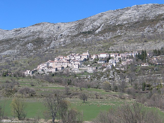
Безодён-лез-Альп (Bézaudun-les-Alpes, Bézaudun-les-Alpes)

- коммуна в департаменте Приморские Альпы, регион Прованс — Альпы — Лазурный Берег, Франция
 Hiking in Безодён-лез-Альп
Bézaudun-les-Alpes is a charming commune located in the Alpes-Maritimes department in southeastern France. The area is known for its stunning natural landscapes, historical architecture, and a variety of hiking opportunities that cater to different experience levels. Here are some highlights and tips for hiking in and around Bézaudun-les-Alpes:
Scenic Trails
-
Local Trails: The region offers numerous trails that take you through picturesque countryside, lush forests, and rocky terrains. You can explore routes that vary in difficulty, making it suitable for both beginners and experienced hikers.
-
Panoramic Views: Many trails provide breathtaking vistas of the surrounding mountains, valleys, and pastures. Don’t forget your camera to capture the stunning scenery!
-
Wildlife: Keep an eye out for local flora and fauna. The area is home to a variety of wildlife, which can be spotted along the trails.
Notable Hikes
-
Sentier des Fées: This trail is well-known in the area and offers a relatively easy hike with enchanting views. It's perfect for families or those looking for a less strenuous option.
-
Montagne de Baou: A more challenging hike, this trail provides opportunities for those looking to engage in a full-day adventure. The summit rewards hikers with panoramic views of the surrounding region.
Preparation Tips
- Weather: Always check the weather forecast before heading out. Conditions can change rapidly in the mountains.
- Footwear: Wear sturdy hiking boots, as some trails can be rocky and uneven.
- Supplies: Carry enough water, snacks, and a first-aid kit. It can be beneficial to have a map or GPS device handy, especially on less marked trails.
- Stay on Trails: To preserve the natural environment, stick to marked trails and avoid trampling on delicate vegetation.
Additional Attractions
After a day of hiking, take time to explore the village of Bézaudun-les-Alpes. The local architecture is beautiful, and the tranquil ambiance makes for a lovely evening stroll. The local cafes and restaurants may offer delightful local cuisine to refuel after your hike.
Whether you're looking for a leisurely walk or a challenging ascent, Bézaudun-les-Alpes is an excellent choice for hiking enthusiasts. Enjoy your adventure!
- Страна:

- Почтовый код: 06510
- Координаты: 43° 48' 27" N, 7° 5' 46" E


- GPS треки (wikiloc): [Ссылка]
- Площадь: 21.44 кв.км
- Население: 243
- Веб сайт: http://www.bezaudun.fr
- Википедия русская: wiki(ru)
- Википедия английская: wiki(en)
- Википедия национальная: wiki(fr)
- Хранилище Wikidata: Wikidata: Q845129
- Катеория в википедии: [Ссылка]
- код Freebase: [/m/03m4yvl]
- код Freebase: [/m/03m4yvl]
- код GeoNames: Альт: [6446674]
- код GeoNames: Альт: [6446674]
- номер SIREN: [210600177]
- номер SIREN: [210600177]
- код тезауруса PACTOLS: [pcrt3de4JZay31]
- код тезауруса PACTOLS: [pcrt3de4JZay31]
- код муниципалитета INSEE: 06017
- код муниципалитета INSEE: 06017
Граничит с регионами:


Ванс
- коммуна в департаменте Приморские Альпы, регион Прованс — Альпы — Лазурный Берег, Франция
Hiking in Ванс
Vence, located in the Provence-Alpes-Côte d'Azur region of France, offers a fantastic blend of coastal and mountainous hiking experiences. Here are some highlights and tips for hiking in and around Vence:...
- Страна:
- Почтовый код: 06140
- Координаты: 43° 43' 21" N, 7° 6' 43" E
- GPS треки (wikiloc): [Ссылка]
- Площадь: 39.23 кв.км
- Население: 18393
- Веб сайт: [Ссылка]

Сен-Жанне
- коммуна в департаменте Приморские Альпы, регион Прованс — Альпы — Лазурный Берег, Франция
Hiking in Сен-Жанне
Saint-Jeannet, located in the Alpes-Maritimes region of France, is a charming village that offers a variety of excellent hiking opportunities. Nestled in the foothills of the French Alps, it provides stunning views, diverse terrain, and a rich natural environment that attracts outdoor enthusiasts....
- Страна:
- Почтовый код: 06640
- Координаты: 43° 44' 47" N, 7° 8' 36" E
- GPS треки (wikiloc): [Ссылка]
- Площадь: 14.58 кв.км
- Население: 4071


Ле-Брок
- коммуна в департаменте Приморские Альпы, регион Прованс — Альпы — Лазурный Берег, Франция
Hiking in Ле-Брок
Le Broc, located in the Alpes-Maritimes region of France, is a charming village that offers a variety of hiking opportunities suitable for different skill levels. The area's natural beauty is characterized by its rocky landscapes, rolling hills, and stunning views of the surrounding mountains and valleys....
- Страна:
- Почтовый код: 06510
- Координаты: 43° 48' 34" N, 7° 10' 12" E
- GPS треки (wikiloc): [Ссылка]
- Площадь: 18.65 кв.км
- Население: 1401
- Веб сайт: [Ссылка]


Гатьер
- коммуна в департаменте Приморские Альпы, регион Прованс — Альпы — Лазурный Берег, Франция
Hiking in Гатьер
Gattières is a charming village located in the Alpes-Maritimes department in the Provence-Alpes-Côte d'Azur region of France, not far from Nice. The area surrounding Gattières offers a range of hiking opportunities that showcase the stunning landscapes of the French Riviera and the picturesque foothills of the Alps....
- Страна:
- Почтовый код: 06510
- Координаты: 43° 45' 34" N, 7° 10' 33" E
- GPS треки (wikiloc): [Ссылка]
- Площадь: 10.03 кв.км
- Население: 4111
- Веб сайт: [Ссылка]


Буйон
- коммуна в департаменте Приморские Альпы, регион Прованс — Альпы — Лазурный Берег, Франция
Hiking in Буйон
Bouyon is a small village located in the Alpes-Maritimes region of southeastern France, nestled in the hills near Nice. The area offers stunning natural scenery and a variety of hiking opportunities, making it a great destination for outdoor enthusiasts. Here’s what you can expect while hiking in and around Bouyon:...
- Страна:
- Почтовый код: 06510
- Координаты: 43° 49' 28" N, 7° 7' 23" E
- GPS треки (wikiloc): [Ссылка]
- Площадь: 12.29 кв.км
- Население: 494

Курсегуль
- коммуна в департаменте Приморские Альпы, регион Прованс — Альпы — Лазурный Берег, Франция
Hiking in Курсегуль
Coursegoules is a charming village located in the Alpes-Maritimes department in southeastern France. It lies in the foothills of the French Alps, offering stunning scenery, diverse landscapes, and a variety of hiking opportunities suitable for different skill levels....
- Страна:
- Почтовый код: 06140
- Координаты: 43° 47' 36" N, 7° 2' 38" E
- GPS треки (wikiloc): [Ссылка]
- Площадь: 40.98 кв.км
- Население: 524
- Веб сайт: [Ссылка]

Консегюд
- коммуна в департаменте Приморские Альпы, регион Прованс — Альпы — Лазурный Берег, Франция
Hiking in Консегюд
It looks like there may be a typo in your query, as "Conségudes" does not appear to be a recognized hiking destination or area. However, if you're referring to a specific location in the mountains or a national park, please provide more context or check the spelling....
- Страна:
- Почтовый код: 06510
- Координаты: 43° 50' 36" N, 7° 2' 55" E
- GPS треки (wikiloc): [Ссылка]
- Площадь: 12.47 кв.км
- Население: 106


Ле-Фер
- коммуна в департаменте Приморские Альпы, регион Прованс — Альпы — Лазурный Берег, Франция
Hiking in Ле-Фер
Les Ferres is a picturesque village located in the Alpes-Maritimes region of France, near the French Riviera. It sits at an elevation of about 800 meters in the hills above Nice, making it an excellent starting point for various hiking adventures. The area is known for its beautiful landscapes, stunning views, and diverse flora and fauna....
- Страна:
- Почтовый код: 06510
- Координаты: 43° 50' 49" N, 7° 5' 39" E
- GPS треки (wikiloc): [Ссылка]
- Площадь: 13.7 кв.км
- Население: 106