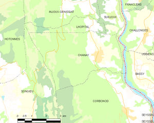
Лопиталь (Lhôpital, Lhôpital)

- коммуна во Франции
 Hiking in Лопиталь
Lhôpital is a village located in the northeastern part of France, near the border with Germany. While it may not be widely recognized as a major hiking destination, the surrounding region offers scenic trails and outdoor activities that can appeal to hikers looking to explore the Alsace region.
Hiking Trails and Areas
-
Vosges Mountains: Just a short drive from Lhôpital, the Vosges Mountains offer numerous hiking trails with varying levels of difficulty. You can find routes that highlight the beautiful landscapes, lakes, and forests typical of the region.
-
Forests: The area surrounding Lhôpital features lush forests with trails suitable for walking and hiking. Exploring these forests can be refreshing, especially during the spring and fall when the foliage is vibrant.
-
Local Attractions: Consider combining your hiking adventures with visits to nearby attractions like vineyards, historical sites, and charming villages. The culture and history of Alsace can enhance your hiking experience.
Tips for Hiking in the Region
-
Check Local Maps: Before heading out, it’s wise to acquire local hiking maps or use mobile apps that can help you navigate the trails. Look out for marked paths, as trail markings can vary.
-
Weather Awareness: The weather can change rapidly, especially in the mountains. Dress in layers and check forecasts before you start your hike.
-
Stay Hydrated and Safe: Carry plenty of water and snacks, especially on longer hikes. Always inform someone of your hiking plans and estimated return time.
-
Start with Local Trails: If you’re new to hiking in the area, start with shorter or easier trails to get a feel for the landscape and your own hiking abilities.
Whether you're planning a casual stroll or a more challenging hike, the area around Lhôpital can offer a worthwhile experience filled with natural beauty and tranquility. Enjoy your hike!
- Страна:

- Почтовый код: 01420
- Координаты: 46° 1' 18" N, 5° 46' 42" E


- GPS треки (wikiloc): [Ссылка]
- Площадь: 3.68 кв.км
- Население: 47
- Википедия русская: wiki(ru)
- Википедия английская: wiki(en)
- Википедия национальная: wiki(fr)
- Хранилище Wikidata: Wikidata: Q317956
- Катеория в википедии: [Ссылка]
- Карты в википедии: [Ссылка]
- код Freebase: [/m/08166p]
- код Freebase: [/m/08166p]
- код GeoNames: Альт: [6615622]
- код GeoNames: Альт: [6615622]
- номер SIREN: [210102158]
- номер SIREN: [210102158]
- код муниципалитета INSEE: 01215
- код муниципалитета INSEE: 01215
Граничит с регионами:

Шане
- коммуна во Франции, департамент Эн
Hiking in Шане
Hiking in Chanay, a picturesque destination in the Auvergne-Rhône-Alpes region of France, offers a variety of trails that cater to different skill levels, from easy walks suitable for families to more challenging hikes for experienced adventurers. The area is characterized by its stunning landscapes, featuring rolling hills, dense forests, and breathtaking views of the surrounding mountains....
- Страна:
- Почтовый код: 01420
- Координаты: 46° 0' 22" N, 5° 47' 8" E
- GPS треки (wikiloc): [Ссылка]
- Площадь: 18.1 кв.км
- Население: 640
- Веб сайт: [Ссылка]
Haut-Valromey
Hiking in Haut-Valromey
Haut-Valromey is a beautiful region located in the French Alps, known for its stunning landscapes and outdoor activities, particularly hiking. Here are some key points to consider if you plan to hike in Haut-Valromey:...
- Страна:
- Почтовый код: 01260
- Координаты: 45° 59' 51" N, 5° 41' 42" E
- GPS треки (wikiloc): [Ссылка]
- Площадь: 107.85 кв.км
- Веб сайт: [Ссылка]
Отон
- коммуна во Франции
Hiking in Отон
Hotonnes is a beautiful destination located in the French Alps, offering hikers a range of scenic trails and stunning landscapes. Known for its mountainous terrain, lush pastures, and diverse wildlife, it's an excellent spot for both novice and experienced hikers....
- Страна:
- Почтовый код: 01260
- Координаты: 45° 59' 52" N, 5° 41' 36" E
- GPS треки (wikiloc): [Ссылка]
- Площадь: 28.4 кв.км
- Население: 298
- Веб сайт: [Ссылка]

Энжу-Женисья
- коммуна во Франции
Hiking in Энжу-Женисья
Injoux-Génissiat is a charming commune located in the Ain department of the Auvergne-Rhône-Alpes region in southeastern France. The area is known for its natural beauty, making it a great destination for hiking enthusiasts. Here are some key points about hiking in Injoux-Génissiat:...
- Страна:
- Почтовый код: 01200
- Координаты: 46° 3' 5" N, 5° 48' 9" E
- GPS треки (wikiloc): [Ссылка]
- Площадь: 29.61 кв.км
- Население: 1144
- Веб сайт: [Ссылка]

Сюржу
- коммуна во Франции
Hiking in Сюржу
Surjoux, located in the Auvergne-Rhône-Alpes region of France, offers a variety of hiking opportunities amid stunning natural landscapes. This area is characterized by its lush forests, rolling hills, and picturesque views, making it an appealing destination for hikers of all levels....
- Страна:
- Почтовый код: 01420
- Координаты: 46° 1' 27" N, 5° 48' 10" E
- GPS треки (wikiloc): [Ссылка]
- Площадь: 4.31 кв.км
- Население: 72

Сонжьё
- коммуна во Франции
Hiking in Сонжьё
It seems there might be a typo in your query as there is no widely recognized hiking destination by the name of "Songieu." However, if you meant "Sonjieu," "Songyue," or a similar location, I can still provide general information about hiking in various regions or help with hiking tips and trails in any well-known national parks or hiking areas....
- Страна:
- Почтовый код: 01260
- Координаты: 45° 58' 24" N, 5° 42' 8" E
- GPS треки (wikiloc): [Ссылка]
- Площадь: 20.58 кв.км
- Население: 128