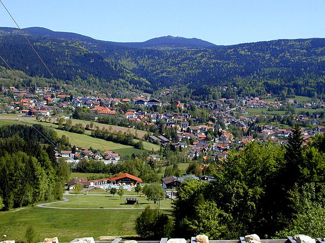
Лоберг (Lohberg, Lohberg)

 Hiking in Лоберг
Lohberg is a beautiful area located in Bavaria, Germany, known for its stunning natural landscapes and outdoor recreational opportunities, including hiking. Nestled in the foothills of the Bavarian Forest, Lohberg offers a variety of trails suitable for different skill levels and preferences. Here are some highlights for hiking in the area:
Trails and Routes
-
Lohberg Panorama Trail:
- This trail offers breathtaking views of the surrounding landscape, including the peaks of the Bavarian Forest National Park. It's great for both beginner and intermediate hikers.
-
Bavarian Forest National Park Trails:
- Nearby, the park features numerous marked trails that vary in length and difficulty. You can explore diverse ecosystems, including dense forests, meadows, and wetlands. The trails are well-maintained and provide opportunities to see local wildlife.
-
The Goldsteig Trail:
- This long-distance hiking route is one of the most famous in Bavaria and passes through Lohberg. It offers a unique experience for those looking to tackle multi-day adventures.
Best Hiking Seasons
- Spring and Summer: Ideal for hiking due to pleasant temperatures and blooming flora. Trails are fully accessible.
- Autumn: Offers stunning fall foliage, making hikes visually striking.
- Winter: While some trails may be closed due to snow, there are opportunities for winter hiking and snowshoeing in the area.
Preparation and Safety Tips
-
Gear: Wear appropriate hiking shoes and clothing suitable for changing weather conditions. A daypack with water, snacks, a first-aid kit, and a map is essential.
-
Navigation: Always carry a map or have a well-loaded GPS app, as some trails can be less marked.
-
Weather: Check the weather forecast before heading out, as conditions can change quickly, especially in mountainous regions.
-
Wildlife Awareness: Be mindful of local wildlife and respect their habitats. If hiking in groups, make noise to avoid surprising animals.
Additional Activities
Apart from hiking, Lohberg offers additional activities, such as mountain biking, skiing in winter, and visiting local attractions like waterfalls and cultural sites. The local community is also known for its hospitality and offers various accommodations ranging from campsites to cozy guesthouses.
Lohberg is an excellent destination for nature lovers and hikers, combining picturesque scenery with well-marked trails and a variety of outdoor activities. Happy hiking!
- Страна:

- Почтовый код: 93470
- Телефонный код: 09943
- Код автомобильного номера: CHA
- Координаты: 49° 11' 0" N, 13° 6' 0" E


- GPS треки (wikiloc): [Ссылка]
- Высота над уровнем моря: 636 м m
- Площадь: 59.25 кв.км
- Население: 2051
- Веб сайт: http://www.lohberg.de/gemeinde/index.html
- Википедия русская: wiki(ru)
- Википедия английская: wiki(en)
- Википедия национальная: wiki(de)
- Хранилище Wikidata: Wikidata: Q508680
- Катеория в википедии: [Ссылка]
- код Freebase: [/m/02q0zqw]
- код GeoNames: Альт: [6556648]
- код VIAF: Альт: [244194049]
- ID отношения в OpenStreetMap: [959917]
- код GND: Альт: [4267555-8]
- код Historical Gazetteer: [LOHER1JN69NE]
- Bavarikon ID: [ODB_A00001769]
- идентификатор муниципалитетов в Германии: 09372178
Граничит с регионами:


Байериш-Айзенштайн
Hiking in Байериш-Айзенштайн
Bayerisch Eisenstein, located in the Bavarian Forest National Park in Germany, is a fantastic destination for hiking enthusiasts. The area is known for its stunning landscapes, diverse flora and fauna, and a wide range of hiking trails suitable for different skill levels....
- Страна:
- Почтовый код: 94252
- Телефонный код: 09925
- Код автомобильного номера: REG
- Координаты: 49° 7' 12" N, 13° 12' 0" E
- GPS треки (wikiloc): [Ссылка]
- Высота над уровнем моря: 724 м m
- Площадь: 47.32 кв.км
- Население: 1007
- Веб сайт: [Ссылка]

Боденмайс
Hiking in Боденмайс
Bodenmais is a charming village located in the Bavarian Forest region of Germany, known for its stunning natural landscapes and extensive hiking trails. Here are some key details about hiking in Bodenmais:...
- Страна:
- Почтовый код: 94249
- Телефонный код: 09924
- Код автомобильного номера: REG
- Координаты: 49° 4' 0" N, 13° 6' 0" E
- GPS треки (wikiloc): [Ссылка]
- Высота над уровнем моря: 689 м m
- Площадь: 45.29 кв.км
- Население: 3397
- Веб сайт: [Ссылка]