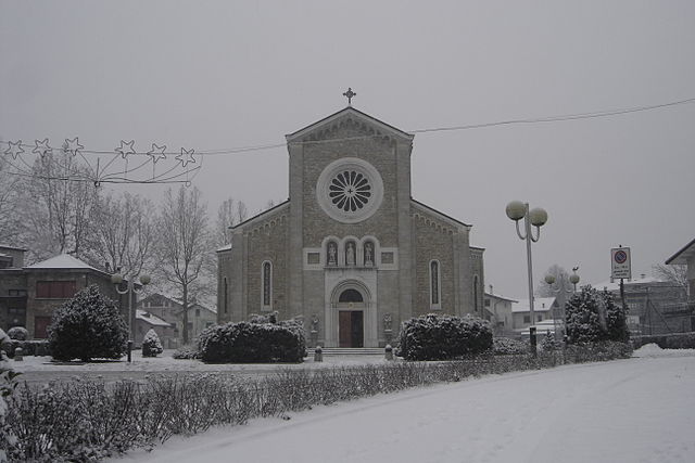
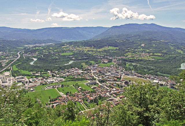
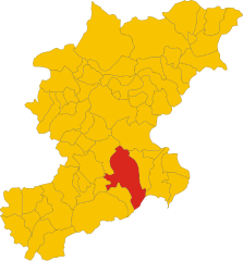
Лонгароне (Longarone, Longarone)
%20until%2020th%20February%202014.svg)
- коммуна Италии
 Hiking in Лонгароне
Longarone, located in the Dolomite region of northern Italy, offers spectacular hiking opportunities amidst stunning landscapes characterized by dramatic mountains, lush valleys, and flowing rivers. Here are some highlights and tips for hiking in and around Longarone:
Hiking Trails:
-
Sentiero di Longarone: This is a well-marked trail that takes you through the surrounding countryside, offering beautiful views of the mountains and the Piave River. It's suitable for various skill levels, making it a great option for families.
-
Val di Zoldo: A short drive from Longarone, this area features numerous trails that cater to different experience levels. You can find paths leading to breathtaking panoramic viewpoints, alpine lakes, and traditional mountain huts.
-
Civetta Mountain: A bit more challenging, hikes in this area provide incredible views of the Dolomites, with various routes available that can accommodate experienced hikers looking for a good workout and stunning scenery.
-
Trekking in the Dolomiti Bellunesi National Park: This park is nearby and offers a vast network of hiking trails with diverse terrain ranging from gentle walks to strenuous climbs. You can enjoy traversing through forests, past meadows, and along rocky ridges.
Tips for Hiking in Longarone:
-
Best Time to Hike: The best months for hiking in this region are typically late spring through early autumn (May to October), when the weather is more favorable, and trails are most accessible.
-
Weather Preparedness: The weather can change rapidly in the mountains. Make sure to check forecasts and come prepared with appropriate clothing and gear, including layers, rain gear, and sturdy hiking boots.
-
Local Guide Services: If you're unfamiliar with the area or new to hiking, consider hiring a local guide. They can provide valuable insights, ensure you are on the best trails suited to your abilities, and enhance your safety.
-
Respect Nature: As with any hiking area, remember to follow Leave No Trace principles. Stay on marked trails, take your litter with you, and respect local wildlife.
-
Map and Navigation: While many trails are well-marked, having a map or a GPS device is wise to navigate effectively, especially in more remote areas.
Cultural and Historical Aspects:
Hiking in Longarone also allows you to experience the rich history and culture of the region. You can find ancient churches, traditional villages, and remnants of the area's history, particularly related to the tragic flood in the 1960s, which reshaped the town.
Whether you're looking for a leisurely stroll or an adventurous trek, Longarone and its surroundings provide a wonderful hiking experience infused with the natural beauty of the Dolomites!
- Страна:

- Почтовый код: 32013
- Телефонный код: 0437
- Код автомобильного номера: BL
- Координаты: 46° 16' 0" N, 12° 18' 0" E


- GPS треки (wikiloc): [Ссылка]
- Высота над уровнем моря: 473 м m
- Площадь: 122.36 кв.км
- Население: 5254
- Веб сайт: http://www.longarone.net
- Википедия русская: wiki(ru)
- Википедия английская: wiki(en)
- Википедия национальная: wiki(it)
- Хранилище Wikidata: Wikidata: Q40161
- Катеория в википедии: [Ссылка]
- код Freebase: [/m/0509lz]
- код GeoNames: Альт: [6538282]
- код VIAF: Альт: [139781426]
- идентификатор местоположения ArchINFORM: [43592]
- UN/LOCODE: [ITLGE]
- код ISTAT: 025071
- кадастровый код Италии: M342
Граничит с регионами:


Соверцене
- коммуна Италии
Hiking in Соверцене
Soverzene, located in the Friuli Venezia Giulia region of Italy, offers stunning landscapes and a variety of hiking opportunities. Situated in the foothills of the Julian Alps, this area is known for its beautiful natural scenery, including dense forests, pristine rivers, and panoramic views of the surrounding mountains....
- Страна:
- Почтовый код: 32010
- Телефонный код: 0437
- Код автомобильного номера: BL
- Координаты: 46° 12' 15" N, 12° 18' 11" E
- GPS треки (wikiloc): [Ссылка]
- Высота над уровнем моря: 424 м m
- Площадь: 14.79 кв.км
- Население: 380
- Веб сайт: [Ссылка]


Ла-Валле-Агордина
- коммуна Италии
Hiking in Ла-Валле-Агордина
La Valle Agordina is a charming village located in the Veneto region of northern Italy, nestled in the Dolomites, a UNESCO World Heritage site. This area offers a stunning array of hiking opportunities, catering to various skill levels, from easy walks to challenging mountain ascents. Here are some highlights and tips for hiking in and around La Valle Agordina:...
- Страна:
- Почтовый код: 32020
- Телефонный код: 0437
- Код автомобильного номера: BL
- Координаты: 46° 16' 53" N, 12° 3' 58" E
- GPS треки (wikiloc): [Ссылка]
- Высота над уровнем моря: 800 м m
- Площадь: 48.67 кв.км
- Население: 1081
- Веб сайт: [Ссылка]

Седико
- коммуна Италии
Hiking in Седико
Sedico, located in the Belluno region of Italy, is surrounded by the beautiful Dolomite mountains, making it a fantastic destination for hiking enthusiasts. The area offers a variety of hiking trails catering to different skill levels, from easy walks to more challenging alpine routes. Here are some highlights to consider when hiking in and around Sedico:...
- Страна:
- Почтовый код: 32036
- Телефонный код: 0437
- Код автомобильного номера: BL
- Координаты: 46° 7' 0" N, 12° 6' 0" E
- GPS треки (wikiloc): [Ссылка]
- Высота над уровнем моря: 317 м m
- Площадь: 91.2 кв.км
- Население: 10119
- Веб сайт: [Ссылка]

Понте-нелле-Альпи
- коммуна Италии
Hiking in Понте-нелле-Альпи
Ponte nelle Alpi, located in the Dolomites region of northern Italy, offers a fantastic environment for hiking enthusiasts. With its breathtaking landscapes, diverse trails, and proximity to nature, it is an ideal destination for both beginner and experienced hikers....
- Страна:
- Почтовый код: 32014
- Телефонный код: 0437
- Код автомобильного номера: BL
- Координаты: 46° 10' 59" N, 12° 16' 45" E
- GPS треки (wikiloc): [Ссылка]
- Высота над уровнем моря: 397 м m
- Площадь: 58.14 кв.км
- Население: 8250
- Веб сайт: [Ссылка]


Эрто-е-Кассо
- коммуна Италии
Hiking in Эрто-е-Кассо
Erto e Casso is a picturesque municipality in the Friuli Venezia Giulia region of Italy, known for its stunning landscapes, rich history, and outdoor activities. It is situated near the Dolomites and the Friulian Alps, making it a great destination for hiking enthusiasts....
- Страна:
- Почтовый код: 33080
- Телефонный код: 0427
- Код автомобильного номера: PN
- Координаты: 46° 16' 35" N, 12° 22' 17" E
- GPS треки (wikiloc): [Ссылка]
- Высота над уровнем моря: 775 м m
- Площадь: 52.43 кв.км
- Население: 371
- Веб сайт: [Ссылка]

Беллуно
- коммуна Италии
Hiking in Беллуно
Belluno, located in the northeastern Italian Alps, is a fantastic destination for hiking enthusiasts. This province is known for its breathtaking landscapes, diverse ecosystems, and a range of trails suitable for all levels of hikers. Here are some key highlights about hiking in Belluno:...
- Страна:
- Почтовый код: 32100
- Телефонный код: 0437
- Код автомобильного номера: BL
- Координаты: 46° 8' 27" N, 12° 12' 56" E
- GPS треки (wikiloc): [Ссылка]
- Высота над уровнем моря: 390 м m
- Площадь: 147.22 кв.км
- Население: 35710
- Веб сайт: [Ссылка]