
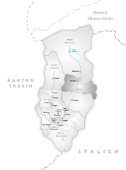
Лосталло (Lostallo, Lostallo)

 Hiking in Лосталло
Lostallo, located in the beautiful region of Graubünden in Switzerland, is a fantastic location for hiking enthusiasts. Nestled in the heart of the Alps, this small village offers access to stunning scenery, serene nature, and diverse trails suitable for all skill levels.
Key Features of Hiking in Lostallo:
-
Scenic Trails: The region boasts a variety of hiking trails, ranging from easy walks suitable for families to more challenging routes for experienced hikers. Many trails offer stunning views of the surrounding mountains, lush valleys, and the picturesque landscape of Graubünden.
-
Nature and Wildlife: The area around Lostallo is rich in natural beauty, with opportunities to see diverse flora and fauna. Depending on the season, you may encounter wildflowers, alpine meadows, and possibly even wildlife such as deer and various bird species.
-
Cultural Experience: Hiking in this region also allows you to explore the local traditions and culture of the Graubünden canton. You may find charming villages, local cuisine, and historical sites along the trails.
-
Accessibility: Lostallo is well-connected by public transportation, making it accessible for those looking to explore the region without a car. In addition, some trails can lead you from Lostallo to nearby towns and attractions.
-
Seasonal Hiking: While summer is the peak season for hiking in Lostallo, autumn provides stunning fall foliage, and winter offers opportunities for snowshoeing and winter hiking. Always check trail conditions and accessibility, especially during off-peak seasons.
-
Local Tips: It’s advisable to carry adequate gear, including proper footwear, water, snacks, and a map or GPS device. Check the weather conditions before heading out and consider using local hiking guides for a more in-depth exploration of the area.
-
Nearby Attractions: For those looking to expand their hiking adventures, nearby spots such as the Bregaglia Valley and the scenery around Soglio offer additional trails and breathtaking views.
Whether you’re looking for a leisurely day hike or a multi-day adventure, Lostallo and its surroundings offer ample opportunities to immerse yourself in the natural beauty of the Swiss Alps. Always remember to follow local guidelines and respect nature while hiking. Happy trails!
- Страна:

- Почтовый код: 6558
- Телефонный код: 091
- Код автомобильного номера: GR
- Координаты: 46° 18' 25" N, 9° 13' 29" E


- GPS треки (wikiloc): [Ссылка]
- Высота над уровнем моря: 1685 м m
- Площадь: 50.86 кв.км
- Население: 760
- Веб сайт: http://www.lostallo.ch
- Википедия русская: wiki(ru)
- Википедия английская: wiki(en)
- Википедия национальная: wiki(de)
- Хранилище Wikidata: Wikidata: Q65115
- Катеория в википедии: [Ссылка]
- код Freebase: [/m/026h2c8]
- код GeoNames: Альт: [7286373]
- код VIAF: Альт: [123970696]
- ID отношения в OpenStreetMap: [1684104]
- код GND: Альт: [2138776-X]
- идентификатор местоположения ArchINFORM: [8617]
- место в MusicBrainz: [af959b28-f36a-4c82-b6f8-bb4bdd7c9ed0]
- идентификатор HDS: [1556]
- код швейцарского муниципалитета: [3821]
- LIR: [1384]
Граничит с регионами:


Гордона
- коммуна Италии
Hiking in Гордона
Gordona, located in the Italian region of Lombardy, is a picturesque area that offers beautiful hiking opportunities surrounded by nature. Situated in the province of Sondrio, not far from the Alps, Gordona is known for its stunning landscapes, lush forests, and charming villages....
- Страна:

- Почтовый код: 23020
- Телефонный код: 0343
- Код автомобильного номера: SO
- Координаты: 46° 17' 0" N, 9° 22' 0" E
- GPS треки (wikiloc): [Ссылка]
- Высота над уровнем моря: 283 м m
- Площадь: 62.79 кв.км
- Население: 1970
- Веб сайт: [Ссылка]


Вердаббио
Hiking in Вердаббио
Verdabbio is a charming village located in the Italian-speaking canton of Ticino, Switzerland. Nestled in the picturesque mountains, it offers a variety of hiking opportunities that cater to different skill levels. Here are some highlights and tips for hiking in and around Verdabbio:...
- Страна:
- Почтовый код: 6538
- Телефонный код: 091
- Код автомобильного номера: GR
- Координаты: 46° 16' 25" N, 9° 12' 7" E
- GPS треки (wikiloc): [Ссылка]
- Высота над уровнем моря: 1800 м m
- Площадь: 13.13 кв.км
- Веб сайт: [Ссылка]


Кауко
Hiking in Кауко
Cauco, a beautiful and less-traveled area, offers a variety of hiking experiences characterized by stunning landscapes, diverse ecosystems, and rich cultural experiences. While specific trails can vary based on the exact location within Cauco, I can provide general information that may help you plan your hiking adventure in this region....
- Страна:
- Почтовый код: 6546
- Телефонный код: 091
- Код автомобильного номера: GR
- Координаты: 46° 20' 7" N, 9° 7' 15" E
- GPS треки (wikiloc): [Ссылка]
- Высота над уровнем моря: 1057 м m
- Площадь: 10.89 кв.км
- Веб сайт: [Ссылка]

Соацца
Hiking in Соацца
Soazza is a charming village located in the Ticino region of Switzerland, surrounded by stunning natural landscapes that make it an excellent destination for hiking enthusiasts. Nestled in the mountains, Soazza offers a variety of trails suitable for all skill levels, from easy walks to more challenging hikes....
- Страна:
- Почтовый код: 6562
- Телефонный код: 091
- Код автомобильного номера: GR
- Координаты: 46° 20' 59" N, 9° 12' 59" E
- GPS треки (wikiloc): [Ссылка]
- Высота над уровнем моря: 620 м m
- Площадь: 46.42 кв.км
- Население: 337
- Веб сайт: [Ссылка]


Кама
- муниципалитет в Швейцарии
Hiking in Кама
Cama, located in the picturesque Graubünden region of Switzerland, offers some stunning hiking opportunities. This small village, nestled in the valley near the Albula River, is surrounded by beautiful alpine scenery, making it a great destination for both day hikes and more extended trekking adventures....
- Страна:
- Почтовый код: 6557
- Телефонный код: 091
- Код автомобильного номера: GR
- Координаты: 46° 15' 35" N, 9° 12' 27" E
- GPS треки (wikiloc): [Ссылка]
- Высота над уровнем моря: 1598 м m
- Площадь: 15.0 кв.км
- Население: 564
- Веб сайт: [Ссылка]