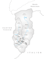
Кама (Cama, Cama)

- муниципалитет в Швейцарии
 Hiking in Кама
Cama, located in the picturesque Graubünden region of Switzerland, offers some stunning hiking opportunities. This small village, nestled in the valley near the Albula River, is surrounded by beautiful alpine scenery, making it a great destination for both day hikes and more extended trekking adventures.
Hiking Highlights:
-
Scenic Trails: The area around Cama features a variety of hiking trails that cater to different skill levels. Whether you're looking for a leisurely walk or a challenging hike, you'll find options that provide breathtaking views of the Swiss Alps and lush valleys.
-
Natural Beauty: The hiking routes often lead through diverse landscapes, including dense forests, alpine meadows filled with wildflowers, and rocky outcrops. In the right season, you may also spot local wildlife, such as chamois and various bird species.
-
Cultural Experience: Many trails pass by traditional Swiss chalets and farms, giving hikers an opportunity to experience the local culture and heritage of the region. Be sure to try some local delicacies or visit a cheese-making farm if you get the chance.
-
Access to Larger Trail Networks: Cama acts as a gateway to larger hiking routes, including the famous Via Albula, which connects various villages and offers stunning panoramic views. You can easily make a day or multi-day hike that incorporates several destinations in the region.
-
Hiking Seasons: The best times to hike in and around Cama are late spring to early autumn (May to October), as snow may still be present on higher trails in early spring and late autumn. Always check local conditions before setting out.
Recommendations:
- Stay Hydrated: Always carry enough water and snacks, especially on longer hikes.
- Wear Proper Equipment: Good hiking boots and weather-appropriate clothing are essential.
- Respect Nature: Stick to marked trails and carry out any trash to preserve the natural beauty of the area.
- Check Local Guides: Consider consulting local hiking maps or guides for the latest trail conditions and recommendations.
If you’re planning a visit to Cama for hiking, be sure to take your time to enjoy the stunning landscapes and the tranquility of the Swiss nature!
- Страна:

- Почтовый код: 6557
- Телефонный код: 091
- Код автомобильного номера: GR
- Координаты: 46° 15' 35" N, 9° 12' 27" E


- GPS треки (wikiloc): [Ссылка]
- Высота над уровнем моря: 1598 м m
- Площадь: 15.0 кв.км
- Население: 564
- Веб сайт: http://www.valcama.ch
- Википедия русская: wiki(ru)
- Википедия английская: wiki(en)
- Википедия национальная: wiki(de)
- Хранилище Wikidata: Wikidata: Q66024
- Катеория в википедии: [Ссылка]
- код Freebase: [/m/026h23q]
- код GeoNames: Альт: [7285423]
- код VIAF: Альт: [265901476]
- ID отношения в OpenStreetMap: [1684055]
- код GND: Альт: [4674777-1]
- идентификатор HDS: [1559]
- код швейцарского муниципалитета: [3831]
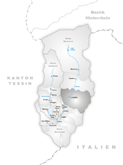
Граничит с регионами:


Гордона
- коммуна Италии
Hiking in Гордона
Gordona, located in the Italian region of Lombardy, is a picturesque area that offers beautiful hiking opportunities surrounded by nature. Situated in the province of Sondrio, not far from the Alps, Gordona is known for its stunning landscapes, lush forests, and charming villages....
- Страна:

- Почтовый код: 23020
- Телефонный код: 0343
- Код автомобильного номера: SO
- Координаты: 46° 17' 0" N, 9° 22' 0" E
- GPS треки (wikiloc): [Ссылка]
- Высота над уровнем моря: 283 м m
- Площадь: 62.79 кв.км
- Население: 1970
- Веб сайт: [Ссылка]
Ливо
- коммуна в провинции Комо, Италия
Hiking in Ливо
Livo is a picturesque village located in the province of Sondrio in Lombardy, Italy. It is situated in the northern part of the region, close to the shores of Lake Como, and is surrounded by beautiful mountains and lush landscapes. Hiking in Livo offers various trails that cater to different skill levels, making it an excellent destination for both novice and experienced hikers....
- Страна:
- Почтовый код: 22010
- Телефонный код: 0344
- Код автомобильного номера: CO
- Координаты: 46° 10' 0" N, 9° 18' 0" E
- GPS треки (wikiloc): [Ссылка]
- Высота над уровнем моря: 675 м m
- Площадь: 33.13 кв.км
- Население: 171
- Веб сайт: [Ссылка]
Доссо-дель-Лиро
- коммуна Италии
Hiking in Доссо-дель-Лиро
Dosso del Liro is a beautiful destination for hiking enthusiasts, located in the northern part of Italy, close to the shores of Lake Como in the Lombardy region. The area is characterized by its picturesque landscapes, lush greenery, and stunning views of the surrounding mountains and valleys. Here are some key points to consider when planning a hiking trip to Dosso del Liro:...
- Страна:
- Почтовый код: 22015
- Телефонный код: 0344
- Код автомобильного номера: CO
- Координаты: 46° 10' 0" N, 9° 16' 0" E
- GPS треки (wikiloc): [Ссылка]
- Высота над уровнем моря: 650 м m
- Площадь: 23.49 кв.км
- Население: 262
- Веб сайт: [Ссылка]

Леджа
Hiking in Леджа
Leggia, located in the picturesque region of Val Bregaglia in Switzerland, offers an array of hiking opportunities for outdoor enthusiasts. The area is known for its stunning landscapes, featuring lush forests, alpine meadows, and spectacular views of the surrounding mountains, including the Bregaglia Range and the Swiss Alps....
- Страна:
- Почтовый код: 6556
- Телефонный код: 091
- Код автомобильного номера: GR
- Координаты: 46° 15' 1" N, 9° 11' 14" E
- GPS треки (wikiloc): [Ссылка]
- Высота над уровнем моря: 1187 м m
- Площадь: 9.15 кв.км
- Веб сайт: [Ссылка]

Лосталло
Hiking in Лосталло
Lostallo, located in the beautiful region of Graubünden in Switzerland, is a fantastic location for hiking enthusiasts. Nestled in the heart of the Alps, this small village offers access to stunning scenery, serene nature, and diverse trails suitable for all skill levels....
- Страна:
- Почтовый код: 6558
- Телефонный код: 091
- Код автомобильного номера: GR
- Координаты: 46° 18' 25" N, 9° 13' 29" E
- GPS треки (wikiloc): [Ссылка]
- Высота над уровнем моря: 1685 м m
- Площадь: 50.86 кв.км
- Население: 760
- Веб сайт: [Ссылка]


Вердаббио
Hiking in Вердаббио
Verdabbio is a charming village located in the Italian-speaking canton of Ticino, Switzerland. Nestled in the picturesque mountains, it offers a variety of hiking opportunities that cater to different skill levels. Here are some highlights and tips for hiking in and around Verdabbio:...
- Страна:
- Почтовый код: 6538
- Телефонный код: 091
- Код автомобильного номера: GR
- Координаты: 46° 16' 25" N, 9° 12' 7" E
- GPS треки (wikiloc): [Ссылка]
- Высота над уровнем моря: 1800 м m
- Площадь: 13.13 кв.км
- Веб сайт: [Ссылка]


Гроно
Hiking in Гроно
Grono, a charming village located in the canton of Grisons (Graubünden) in Switzerland, offers stunning landscapes and a variety of hiking opportunities. The area is characterized by picturesque views of the surrounding mountains, lush valleys, and the serene atmosphere of the Swiss Alps....
- Страна:
- Почтовый код: 6537
- Телефонный код: 091
- Код автомобильного номера: GR
- Координаты: 46° 14' 54" N, 9° 8' 52" E
- GPS треки (wikiloc): [Ссылка]
- Высота над уровнем моря: 1073 м m
- Площадь: 14.81 кв.км
- Население: 1373
- Веб сайт: [Ссылка]