Луайет (Loyettes, Loyettes)
- коммуна во Франции
 Hiking in Луайет
Loyettes is a small commune located in the Auvergne-Rhône-Alpes region of France. While it may not be as widely known for hiking as some other areas in the region, there are still opportunities for outdoor activities and enjoying nature nearby.
Hiking Opportunities:
-
Local Trails: While Loyettes itself may not have designated hiking trails, you can explore the surrounding countryside on foot. Look for rural paths that can provide a taste of the natural beauty of the region.
-
Nearby Parks and Nature Reserves: Head to nearby natural parks or reserves, such as the Parc Naturel Régional de la Chartreuse or the Parc des Oiseaux, which are not far from Loyettes. These areas often have marked trails and are great for hiking, birdwatching, and enjoying local flora and fauna.
-
Isère River Walks: The Isère River runs not too far from Loyettes, and walking along its banks can offer a peaceful hiking experience, with scenic views of the water and the surrounding landscape.
Tips for Hiking in Loyettes:
-
Preparation: Always check the local weather conditions and trail maps before heading out. Bring adequate supplies, including water, snacks, a first aid kit, and a map or GPS device.
-
Respect Nature: Stay on marked trails and pack out what you pack in to preserve the natural beauty of the area.
-
Seasonal Considerations: Depending on the time of year, trails may vary in difficulty and accessibility. Spring and fall often offer the best hiking conditions.
-
Local Guides: Consider reaching out to local hiking clubs or guides if you're unfamiliar with the area. They can provide insights and help you discover hidden gems.
Summary:
While Loyettes might not be a major hiking destination, it offers opportunities for outdoor enthusiasts to explore rural trails and nearby nature areas. It's a lovely spot to enjoy the tranquility of the French countryside!
- Страна:

- Почтовый код: 01360
- Координаты: 45° 46' 27" N, 5° 12' 11" E


- GPS треки (wikiloc): [Ссылка]
- Площадь: 21.28 кв.км
- Население: 3145
- Веб сайт: http://www.commune-loyettes.fr
- Википедия русская: wiki(ru)
- Википедия английская: wiki(en)
- Википедия национальная: wiki(fr)
- Хранилище Wikidata: Wikidata: Q648628
- Катеория в википедии: [Ссылка]
- Карты в википедии: [Ссылка]
- код Freebase: [/m/08167h]
- код Freebase: [/m/08167h]
- код GeoNames: Альт: [2997297]
- код GeoNames: Альт: [2997297]
- номер SIREN: [210102240]
- номер SIREN: [210102240]
- код муниципалитета INSEE: 01224
- код муниципалитета INSEE: 01224
Граничит с регионами:


Шаваноз
- коммуна во Франции
Hiking in Шаваноз
Chavanoz is a small town located near the eastern edge of France, close to the city of Lyon. While it may not be as well-known for hiking as some of the larger national parks, the surrounding region offers beautiful landscapes and a variety of trails for outdoor enthusiasts....
- Страна:
- Почтовый код: 38230
- Координаты: 45° 46' 38" N, 5° 10' 18" E
- GPS треки (wikiloc): [Ссылка]
- Площадь: 8.24 кв.км
- Население: 4568
- Веб сайт: [Ссылка]


Верна
- коммуна во Франции
Hiking in Верна
Hiking in Vernas, a picturesque area in the French Alps, offers a variety of trails suited for all skill levels, from gentle walks to challenging mountain ascents. Here are a few key highlights to consider when hiking in this beautiful region:...
- Страна:
- Почтовый код: 38460
- Координаты: 45° 46' 39" N, 5° 16' 54" E
- GPS треки (wikiloc): [Ссылка]
- Площадь: 5.87 кв.км
- Население: 257


Сен-Ромен-де-Жальонас
- коммуна во Франции
Hiking in Сен-Ромен-де-Жальонас
Saint-Romain-de-Jalionas is a charming commune located in the Auvergne-Rhône-Alpes region of France, specifically within the Isère department. While it may not be as widely known as some other hiking destinations, it offers opportunities for those looking to explore the natural beauty of the area....
- Страна:
- Почтовый код: 38460
- Координаты: 45° 45' 11" N, 5° 13' 12" E
- GPS треки (wikiloc): [Ссылка]
- Площадь: 13.65 кв.км
- Население: 3216

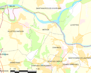
Антон
- коммуна во Франции
- Страна:
- Почтовый код: 38280
- Координаты: 45° 47' 27" N, 5° 10' 11" E
- GPS треки (wikiloc): [Ссылка]
- Площадь: 8.82 кв.км
- Население: 1037
- Веб сайт: [Ссылка]
Сен-Морис-де-Гурдан
- коммуна во Франции
- Страна:
- Почтовый код: 01800
- Координаты: 45° 49' 17" N, 5° 11' 44" E
- GPS треки (wikiloc): [Ссылка]
- Площадь: 25.39 кв.км
- Население: 2509
- Веб сайт: [Ссылка]

Сен-Жан-де-Ньо
- коммуна во Франции
- Страна:
- Почтовый код: 01800
- Координаты: 45° 50' 24" N, 5° 13' 7" E
- GPS треки (wikiloc): [Ссылка]
- Площадь: 14.19 кв.км
- Население: 1418
- Веб сайт: [Ссылка]

Сен-Вюльба
- коммуна во Франции
Hiking in Сен-Вюльба
Saint-Vulbas is a charming commune located in the Ain department of the Auvergne-Rhône-Alpes region in France. It’s a great spot for hiking enthusiasts due to its picturesque landscapes, relatively accessible trail systems, and proximity to natural features....
- Страна:
- Почтовый код: 01150
- Координаты: 45° 50' 2" N, 5° 17' 27" E
- GPS треки (wikiloc): [Ссылка]
- Площадь: 21.44 кв.км
- Население: 1194
- Веб сайт: [Ссылка]