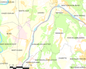
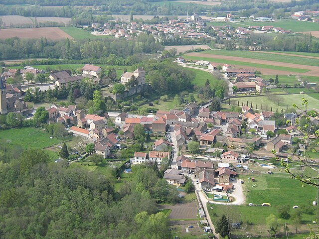
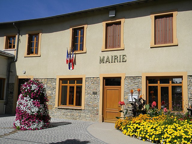
Сен-Вюльба (Saint-Vulbas, Saint-Vulbas)
- коммуна во Франции
 Hiking in Сен-Вюльба
Saint-Vulbas is a charming commune located in the Ain department of the Auvergne-Rhône-Alpes region in France. It’s a great spot for hiking enthusiasts due to its picturesque landscapes, relatively accessible trail systems, and proximity to natural features.
Hiking Trails
-
Surrounding Countryside:
- The area around Saint-Vulbas offers scenic views of rolling hills, fields, and small forests. You can find many trails suitable for all levels of hikers.
-
Nearby Parks and Natural Reserves:
- The region is close to various nature parks where you can explore longer and more challenging hikes. Nearby natural reserves often feature well-marked trails that showcase local flora and fauna.
-
River Trails:
- The commune is near several rivers, providing trails that follow the waterways. These paths tend to be flatter and are perfect for leisurely walks or family hikes.
Tips for Hiking in Saint-Vulbas
- Appropriate Footwear: Wear sturdy hiking boots or shoes to navigate varied terrains comfortably.
- Weather Check: The weather can change quickly, so check forecasts before heading out.
- Stay Hydrated: Bring plenty of water, especially if you’re planning a long hike.
- Trail Maps: It’s advisable to carry a map or have a hiking app to avoid getting lost, especially if you venture into less-frequented areas.
- Respect Nature: Follow Leave No Trace principles to keep the space clean and enjoyable for everyone.
Local Attractions
While hiking is a popular activity, Saint-Vulbas also has local attractions, including historical buildings, parks, and local cuisine to explore after your hike. You might also want to consider visiting nearby towns and regions that offer diverse hiking experiences.
Conclusion
Hiking in and around Saint-Vulbas can provide a wonderful mix of nature, exercise, and tranquility. Whether you're a novice hiker or an experienced outdoor enthusiast, you'll find trails that match your preferences while enjoying the beautiful French countryside.
- Страна:

- Почтовый код: 01150
- Координаты: 45° 50' 2" N, 5° 17' 27" E


- GPS треки (wikiloc): [Ссылка]
- Площадь: 21.44 кв.км
- Население: 1194
- Веб сайт: http://www.saint-vulbas.fr
- Википедия русская: wiki(ru)
- Википедия английская: wiki(en)
- Википедия национальная: wiki(fr)
- Хранилище Wikidata: Wikidata: Q576732
- Катеория в википедии: [Ссылка]
- Карты в википедии: [Ссылка]
- код Freebase: [/m/081rhh]
- код Freebase: [/m/081rhh]
- код GeoNames: Альт: [2976561]
- код GeoNames: Альт: [2976561]
- номер SIREN: [210103909]
- номер SIREN: [210103909]
- код BNF: [11962211s]
- код BNF: [11962211s]
- код тезауруса PACTOLS: [pcrti9EHM6uoIr]
- код тезауруса PACTOLS: [pcrti9EHM6uoIr]
- код муниципалитета INSEE: 01390
- код муниципалитета INSEE: 01390
Граничит с регионами:

Ла-Бальм-ле-Грот
- коммуна во Франции
Hiking in Ла-Бальм-ле-Грот
La Balme-les-Grottes is a charming village in the Auvergne-Rhône-Alpes region of France, known for its stunning natural surroundings and the remarkable geological formations that attract hikers and outdoor enthusiasts. Here are some highlights regarding hiking in this area:...
- Страна:
- Почтовый код: 38390
- Координаты: 45° 51' 9" N, 5° 20' 12" E
- GPS треки (wikiloc): [Ссылка]
- Площадь: 14.61 кв.км
- Население: 1011
- Веб сайт: [Ссылка]


Верна
- коммуна во Франции
Hiking in Верна
Hiking in Vernas, a picturesque area in the French Alps, offers a variety of trails suited for all skill levels, from gentle walks to challenging mountain ascents. Here are a few key highlights to consider when hiking in this beautiful region:...
- Страна:
- Почтовый код: 38460
- Координаты: 45° 46' 39" N, 5° 16' 54" E
- GPS треки (wikiloc): [Ссылка]
- Площадь: 5.87 кв.км
- Население: 257

Ланьё
- коммуна во Франции
Hiking in Ланьё
Lagnieu is a charming town located in the Auvergne-Rhône-Alpes region of France, surrounded by stunning landscapes that are perfect for hiking enthusiasts. Here are some important aspects to consider if you’re planning to hike in or around Lagnieu:...
- Страна:
- Почтовый код: 01150
- Координаты: 45° 54' 13" N, 5° 20' 57" E
- GPS треки (wikiloc): [Ссылка]
- Площадь: 27.25 кв.км
- Население: 7022
- Веб сайт: [Ссылка]

Сен-Жан-де-Ньо
- коммуна во Франции
- Страна:
- Почтовый код: 01800
- Координаты: 45° 50' 24" N, 5° 13' 7" E
- GPS треки (wikiloc): [Ссылка]
- Площадь: 14.19 кв.км
- Население: 1418
- Веб сайт: [Ссылка]

Иер-сюр-Амби
- коммуна во Франции
Hiking in Иер-сюр-Амби
Hières-sur-Amby is a charming commune located in the Isère department in the Auvergne-Rhône-Alpes region of France. It’s surrounded by natural beauty and offers various hiking opportunities, making it a great destination for outdoor enthusiasts....
- Страна:
- Почтовый код: 38118
- Координаты: 45° 47' 51" N, 5° 17' 38" E
- GPS треки (wikiloc): [Ссылка]
- Высота над уровнем моря: 429 м m
- Площадь: 8.73 кв.км
- Население: 1245
- Веб сайт: [Ссылка]
Луайет
- коммуна во Франции
Hiking in Луайет
Loyettes is a small commune located in the Auvergne-Rhône-Alpes region of France. While it may not be as widely known for hiking as some other areas in the region, there are still opportunities for outdoor activities and enjoying nature nearby....
- Страна:
- Почтовый код: 01360
- Координаты: 45° 46' 27" N, 5° 12' 11" E
- GPS треки (wikiloc): [Ссылка]
- Площадь: 21.28 кв.км
- Население: 3145
- Веб сайт: [Ссылка]

Сент-Жюли
- коммуна во Франции
Hiking in Сент-Жюли
Sainte-Julie, located in the Ain department of France, offers some scenic hiking opportunities that cater to various levels of experience. The region is characterized by beautiful landscapes, including forests, hills, and rivers, making it an attractive destination for nature lovers and outdoor enthusiasts....
- Страна:
- Почтовый код: 01150
- Координаты: 45° 53' 24" N, 5° 16' 42" E
- GPS треки (wikiloc): [Ссылка]
- Площадь: 11.15 кв.км
- Население: 980
- Веб сайт: [Ссылка]

Шазе-сюр-Эн
- коммуна во Франции
Hiking in Шазе-сюр-Эн
Chazey-sur-Ain is a charming commune located in the Ain department of the Auvergne-Rhône-Alpes region in southeastern France. It is situated near the Ain River and offers a picturesque backdrop of natural beauty, making it a lovely area for hiking enthusiasts....
- Страна:
- Почтовый код: 01150
- Координаты: 45° 53' 33" N, 5° 15' 16" E
- GPS треки (wikiloc): [Ссылка]
- Площадь: 21.95 кв.км
- Население: 1516
- Веб сайт: [Ссылка]

Бли
- коммуна во Франции
Hiking in Бли
Blyes is a charming destination for hiking enthusiasts, offering scenic views and a range of trails suitable for various skill levels. While specific hiking routes may vary, the area generally features a mix of forested paths, beautiful landscapes, and potentially encounters with local wildlife....
- Страна:
- Почтовый код: 01150
- Координаты: 45° 50' 49" N, 5° 14' 58" E
- GPS треки (wikiloc): [Ссылка]
- Площадь: 9.32 кв.км
- Население: 1000
- Веб сайт: [Ссылка]