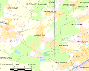
Люттербак (Lutterbach, Lutterbach)

- коммуна во Франции
 Hiking in Люттербак
Lutterbach, a small town in the Grand Est region of France, is not widely known for hiking but can serve as a good base for exploring nearby natural areas and trails. Here’s what you might expect and some recommendations for hiking in and around Lutterbach:
Hiking in Lutterbach and Surroundings
-
Local Trails:
- While Lutterbach itself may not have extensive marked hiking trails, you can find some simple walking paths through forests and fields in the vicinity. These can be great for a leisurely stroll.
-
Nearby Nature Parks:
- Parc de l'Ill: Located in nearby Mulhouse, this park features walking paths and natural scenery which is ideal for casual hikes and enjoying the outdoors.
- Forêt de la Hardt: This forest offers a more immersive natural experience and is great for longer hikes. You can explore various trails and enjoy the local flora and fauna.
-
Regional Hiking:
- The Alsace region is known for its beautiful landscapes, including vineyards, rolling hills, and scenic mountain views. You can venture towards the Vosges Mountains, which offer numerous marked hiking trails of varying difficulty levels.
- GR5 Trail: This long-distance trail passes through the region and can be accessed relatively easily from Lutterbach, allowing you to experience the beauty of the Rhine Valley and the Vosges.
-
Hiking in the Vosges Mountains:
- If you're up for a drive, it's worth heading into the Vosges Mountains for more challenging hikes. The area is rich in hiking opportunities with marked trails like the Sentier des Ocres and Col de la Schlucht area that provide stunning views and diverse terrain.
Tips for Hiking in the Area
- Maps and Resources: Bring a good hiking map or use a GPS-based app to navigate the trails. Always check local resources for trail conditions and updates.
- Local Insights: Consider visiting local tourism offices for trail guides and recommendations tailored to your hiking experience.
- Safety: Always let someone know your plans, carry enough water and snacks, wear appropriate footwear, and check the weather before heading out.
Whether you’re looking for a casual walk nearby or ready for more adventurous hikes in the Alsace or Vosges, you’re sure to enjoy the scenic beauty and fresh air the region has to offer!
- Страна:

- Почтовый код: 68460
- Координаты: 47° 45' 35" N, 7° 16' 50" E


- GPS треки (wikiloc): [Ссылка]
- Площадь: 8.56 кв.км
- Население: 6331
- Веб сайт: http://www.lutterbach.fr/
- Википедия русская: wiki(ru)
- Википедия английская: wiki(en)
- Википедия национальная: wiki(fr)
- Хранилище Wikidata: Wikidata: Q124172
- Катеория в википедии: [Ссылка]
- код Freebase: [/m/03nph59]
- код Freebase: [/m/03nph59]
- код GeoNames: Альт: [2997010]
- код GeoNames: Альт: [2997010]
- номер SIREN: [216801951]
- номер SIREN: [216801951]
- код BNF: [152718979]
- код BNF: [152718979]
- код VIAF: Альт: [235677687]
- код VIAF: Альт: [235677687]
- код GND: Альт: [4629035-7]
- код GND: Альт: [4629035-7]
- WOEID: [609074]
- WOEID: [609074]
- код муниципалитета INSEE: 68195
- код муниципалитета INSEE: 68195
Граничит с регионами:


Фастат
- коммуна во Франции
Hiking in Фастат
Pfastatt is a commune located in the Grand Est region of northeastern France, specifically in the Haut-Rhin department. While it may not be as widely known as some of the larger hiking destinations in France, it offers some charming outdoor experiences, particularly for those who enjoy exploring the Alsace region's natural beauty....
- Страна:
- Почтовый код: 68120
- Координаты: 47° 46' 8" N, 7° 18' 6" E
- GPS треки (wikiloc): [Ссылка]
- Площадь: 5.24 кв.км
- Население: 9423

Моршвиллер-ле-Ба
- коммуна во Франции
Hiking in Моршвиллер-ле-Ба
Morschwiller-le-Bas, located in the Alsace region of France, offers a variety of hiking opportunities for nature lovers and outdoor enthusiasts. While it may be a small town, it has access to beautiful landscapes and trails in the surrounding areas....
- Страна:
- Почтовый код: 68790
- Координаты: 47° 44' 9" N, 7° 16' 14" E
- GPS треки (wikiloc): [Ссылка]
- Площадь: 7.55 кв.км
- Население: 3667

Рененг
- коммуна во Франции
Hiking in Рененг
Reiningue is a small commune in the Grand Est region of France, close to the border with Germany. While it may not be as widely recognized as a hiking destination, the surrounding region offers some beautiful natural landscapes and hiking opportunities....
- Страна:
- Почтовый код: 68950
- Координаты: 47° 45' 2" N, 7° 13' 53" E
- GPS треки (wikiloc): [Ссылка]
- Площадь: 18.54 кв.км
- Население: 1965
- Веб сайт: [Ссылка]


Серне
- Страна:
- Почтовый код: 68700
- Координаты: 47° 48' 24" N, 7° 10' 33" E
- GPS треки (wikiloc): [Ссылка]
- Площадь: 18.04 кв.км
- Население: 11608
- Веб сайт: [Ссылка]

Виттельсайм
- коммуна во Франции
- Страна:
- Почтовый код: 68310
- Координаты: 47° 48' 19" N, 7° 14' 15" E
- GPS треки (wikiloc): [Ссылка]
- Площадь: 23.63 кв.км
- Население: 10384
- Веб сайт: [Ссылка]


Мюлуз
- коммуна во Франции
Hiking in Мюлуз
Mulhouse, located in the Alsace region of northeastern France, is surrounded by a varied landscape ideal for hiking enthusiasts. While Mulhouse itself may be more urban, it serves as a convenient base for exploring nearby natural areas, particularly the Vosges Mountains to the west and the Rhine River valley to the east. Here are some highlights and tips for hiking around Mulhouse:...
- Страна:
- Почтовый код: 68100–68200
- Координаты: 47° 44' 55" N, 7° 20' 21" E
- GPS треки (wikiloc): [Ссылка]
- Высота над уровнем моря: 240 м m
- Площадь: 22.18 кв.км
- Население: 110370
- Веб сайт: [Ссылка]