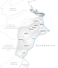
Лутценберг (Lutzenberg, Lutzenberg AR)

 Hiking in Лутценберг
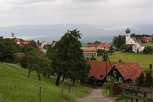
Lutzenberg is a charming community located in the Appenzell District of Switzerland, known for its picturesque landscapes and proximity to the beautiful Appenzell region. Hiking in Lutzenberg offers stunning vistas of rolling hills, lush forests, and scenic views of the Swiss Alps.
Hiking Opportunities
-
Local Trails: There are numerous well-marked hiking trails that cater to various skill levels, from easy walks for families to more challenging routes for experienced hikers. The trails often pass through scenic farmland, forests, and along ridges providing wonderful views of the surrounding countryside.
-
Appenzeller Land: Lutzenberg is situated near the Appenzeller Land, where you can access the iconic "Appenzeller Trails." These include hikes that offer insights into local culture and traditions, as well as beautiful natural scenery.
-
Alpine Views: Many trails around Lutzenberg feature panoramic views of the Alps, making for perfect photo opportunities. Don't miss hikes that take you to higher altitudes for breathtaking vistas.
-
Seasonal Hiking: In spring and summer, you'll see wildflowers in bloom, while fall offers stunning foliage colors. Winter hikes can also be enjoyable, though be sure to check local conditions and recommendations regarding snow and ice.
-
Safety and Preparation: Always carry sufficient water, wear sturdy footwear, and dress in layers suitable for changing weather conditions, especially since mountain weather can be unpredictable. It’s also advisable to tell someone your planned route and expected return time.
-
Guided Tours: If you're unfamiliar with the area or prefer a guided experience, look for local hiking tours. They can provide expert knowledge about the local ecology, history, and geography.
Useful Tips
- Trail Maps: Obtain trail maps and guides from local tourist information centers.
- Local Cuisine: After a day of hiking, explore local restaurants and try traditional dishes from the Appenzell region.
- Public Transport: Lutzenberg is accessible via public transportation, making it easy to reach trailheads or nearby towns.
Overall, hiking in Lutzenberg offers a beautiful blend of nature, culture, and tranquility, making it a fantastic destination for hikers of all levels. Enjoy your outdoor adventure!
- Страна:

- Почтовый код: 9426
- Телефонный код: 071
- Код автомобильного номера: AR
- Координаты: 47° 27' 29" N, 9° 35' 1" E


- GPS треки (wikiloc): [Ссылка]
- Высота над уровнем моря: 523 м m
- Площадь: 2.26 кв.км
- Население: 1253
- Веб сайт: http://www.lutzenberg.ch
- Википедия русская: wiki(ru)
- Википедия английская: wiki(en)
- Википедия национальная: wiki(de)
- Хранилище Wikidata: Wikidata: Q67178
- Катеория в википедии: [Ссылка]
- код Freebase: [/m/01v6fq]
- код GeoNames: Альт: [7286406]
- ID отношения в OpenStreetMap: [1683903]
- идентификатор HDS: [1307]
- код швейцарского муниципалитета: [3033]
Граничит с регионами:


Вальценхаузен
Hiking in Вальценхаузен
Walzenhausen, located in Switzerland, is an excellent destination for hiking enthusiasts. Situated in the canton of Appenzell, it offers stunning views of the surrounding landscapes, including the Rhine Valley and the Swiss Alps....
- Страна:
- Почтовый код: 9428
- Телефонный код: 071
- Код автомобильного номера: AR
- Координаты: 47° 26' 37" N, 9° 35' 51" E
- GPS треки (wikiloc): [Ссылка]
- Высота над уровнем моря: 824 м m
- Площадь: 6.98 кв.км
- Население: 1994
- Веб сайт: [Ссылка]


Таль
Hiking in Таль
Thal, located in the canton of St. Gallen, Switzerland, offers some beautiful hiking opportunities that cater to different skill levels. The region is characterized by picturesque landscapes, rolling hills, and stunning views of the surrounding mountains. Here are some highlights and tips for hiking in Thal:...
- Страна:
- Почтовый код: 9425
- Телефонный код: 071
- Код автомобильного номера: SG
- Координаты: 47° 28' 42" N, 9° 33' 24" E
- GPS треки (wikiloc): [Ссылка]
- Высота над уровнем моря: 397 м m
- Площадь: 9.58 кв.км
- Население: 6480
- Веб сайт: [Ссылка]


Вольфхальден
Hiking in Вольфхальден
Wolfhalden is a picturesque municipality in the Appenzell Innerrhoden region of Switzerland, surrounded by beautiful landscapes and offering a range of hiking opportunities. Here’s what you need to know about hiking in this area:...
- Страна:
- Почтовый код: 9427
- Телефонный код: 071
- Код автомобильного номера: AR
- Координаты: 47° 26' 59" N, 9° 33' 38" E
- GPS треки (wikiloc): [Ссылка]
- Высота над уровнем моря: 673 м m
- Площадь: 6.95 кв.км
- Население: 1836
- Веб сайт: [Ссылка]

Санкт-Маргретен
Hiking in Санкт-Маргретен
St. Margrethen is a picturesque town located in the canton of St. Gallen in Switzerland, near the shores of Lake Constance. The area offers several opportunities for hiking enthusiasts, with trails that vary in difficulty and length, catering to different skill levels....
- Страна:
- Почтовый код: 9430
- Телефонный код: 071
- Код автомобильного номера: SG
- Координаты: 47° 27' 12" N, 9° 37' 34" E
- GPS треки (wikiloc): [Ссылка]
- Высота над уровнем моря: 408 м m
- Площадь: 6.85 кв.км
- Население: 5889
- Веб сайт: [Ссылка]

Роршахерберг
Hiking in Роршахерберг
Rorschacherberg is a beautiful hiking destination located in Switzerland, near Lake Constance. The area is known for its stunning landscapes, picturesque views, and well-marked hiking trails suitable for different skill levels. Here are some key points to consider when hiking in Rorschacherberg:...
- Страна:
- Почтовый код: 9404
- Телефонный код: 071
- Код автомобильного номера: SG
- Координаты: 47° 27' 59" N, 9° 30' 0" E
- GPS треки (wikiloc): [Ссылка]
- Высота над уровнем моря: 570 м m
- Площадь: 7.11 кв.км
- Население: 7177
- Веб сайт: [Ссылка]

Эггерсрит
Hiking in Эггерсрит
Eggersriet is a charming little town located in the canton of St. Gallen, Switzerland, nestled amidst beautiful landscapes. Hiking in and around Eggersriet allows you to enjoy breathtaking views of the surrounding hills, forests, and rural scenery....
- Страна:
- Почтовый код: 9034
- Телефонный код: 071
- Код автомобильного номера: SG
- Координаты: 47° 26' 59" N, 9° 27' 59" E
- GPS треки (wikiloc): [Ссылка]
- Высота над уровнем моря: 817 м m
- Площадь: 8.82 кв.км
- Население: 2275
- Веб сайт: [Ссылка]


Хайден
- коммуна в кантоне Аппенцелль-Ауссерроден (Швейцария)
Hiking in Хайден
Heiden is a picturesque village located in the Appenzell region of Switzerland, known for its stunning views of Lake Constance and its surrounding mountains. Hiking in and around Heiden offers a range of scenic trails suitable for different skill levels, making it a delightful destination for outdoor enthusiasts. Here are some highlights:...
- Страна:
- Почтовый код: 9410
- Телефонный код: 071
- Код автомобильного номера: AR
- Координаты: 47° 26' 28" N, 9° 31' 52" E
- GPS треки (wikiloc): [Ссылка]
- Высота над уровнем моря: 802 м m
- Площадь: 7.5 кв.км
- Население: 4192
- Веб сайт: [Ссылка]


Райнек
Hiking in Райнек
Rheineck, located in the canton of St. Gallen in Switzerland, offers a variety of hiking opportunities that cater to different skill levels and preferences. The area is known for its beautiful landscapes, including rolling hills, lush forests, and stunning views of Lake Constance and the surrounding mountains. Here are some highlights and tips for hiking in Rheineck:...
- Страна:
- Почтовый код: 9424
- Телефонный код: 071
- Код автомобильного номера: SG
- Координаты: 47° 28' 12" N, 9° 35' 0" E
- GPS треки (wikiloc): [Ссылка]
- Высота над уровнем моря: 399 м m
- Площадь: 2.18 кв.км
- Население: 3485
- Веб сайт: [Ссылка]