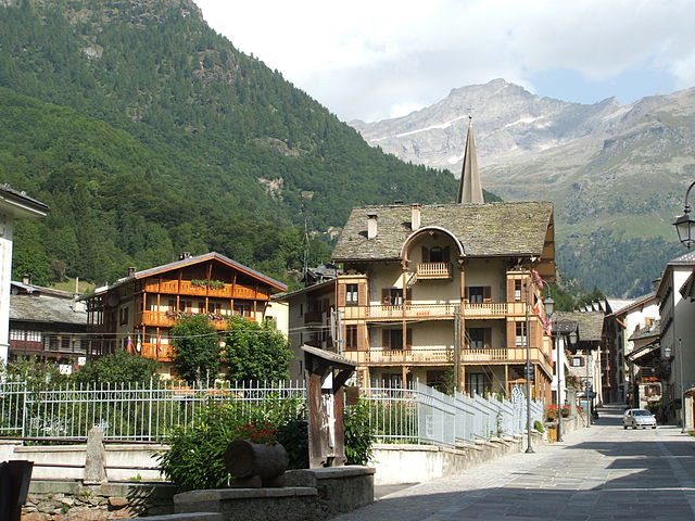
Макуньяга (Macugnaga, Macugnaga)
- коммуна Италии
 Hiking in Макуньяга
Macugnaga is a beautiful village located in the Italian Alps, specifically in the Piedmont region. It sits at the foot of the impressive Monte Rosa massif, which offers a stunning backdrop for hiking enthusiasts. Here are some key points to consider about hiking in Macugnaga:
Scenic Trails
-
Diverse Terrain: The area boasts a variety of trails suited for different skill levels, from easy walks to challenging ascents. You can trek through peaceful forests, alpine meadows, and rocky mountain paths.
-
Della Vetta Trail: This is one of the more popular hikes, leading you to the summit with breathtaking views of Monte Rosa. The trail can be demanding, so prepare accordingly.
-
Sentiero dei Fiori (Flower Trail): Ideal for families and casual hikers, this trail features splendid views and blooming wildflowers, especially during late spring and summer.
-
Historic Trails: There are also paths that lead to historical sites, giving you a glimpse into the local culture and heritage. Look for signs that explain the history of the region and its mining heritage.
Best Time to Hike
-
Summer (June to September): The best time for hiking is during the summer months when the weather is generally warm and the trails are clear of snow. However, always check local conditions as mountain weather can change rapidly.
-
Autumn (October): This can also be a magical time to hike as the leaves change color, though the weather may be cooler and less predictable.
Preparation
-
Gear: Make sure you have the proper hiking gear, including sturdy boots, weather-appropriate clothing, a map, and plenty of water. Trekking poles are also recommended for uneven terrain.
-
Guided Tours: If you are not familiar with the area or prefer to have expert guidance, consider hiring a local guide. They can provide valuable insights about the flora, fauna, and geology, as well as ensure your safety.
-
Wildlife: Be mindful of local wildlife and maintain a respectful distance. Early morning hikes are a great opportunity to spot animal activity.
Safety Tips
- Always let someone know your hiking plans and estimated return time.
- Carry a first-aid kit and know basic first aid procedures.
- Be aware of altitude sickness if you're hiking at higher elevations and acclimate as needed.
- Check for any marked hazards along the trails, such as loose rocks or steep drop-offs.
Conclusion
Hiking in Macugnaga is a rewarding experience that combines physical activity with breathtaking natural beauty. Whether you’re an experienced hiker or a beginner, the trails around Macugnaga offer something for everyone. Enjoy the stunning alpine scenery and the tranquility of the mountains!
- Страна:

- Почтовый код: 28876
- Телефонный код: 0324
- Код автомобильного номера: VB
- Координаты: 45° 58' 0" N, 7° 58' 0" E


- GPS треки (wikiloc): [Ссылка]
- Высота над уровнем моря: 1327 м m
- Площадь: 99.57 кв.км
- Население: 548
- Веб сайт: http://www.comune.macugnaga.vb.it
- Википедия русская: wiki(ru)
- Википедия английская: wiki(en)
- Википедия национальная: wiki(it)
- Хранилище Wikidata: Wikidata: Q23607
- Катеория в википедии: [Ссылка]
- код Freebase: [/m/08v28g]
- код GeoNames: Альт: [6536415]
- код VIAF: Альт: [126651894]
- ID отношения в OpenStreetMap: [46485]
- код ISTAT: 103039
- кадастровый код Италии: E790
Граничит с регионами:
Чеппо-Морелли
- коммуна Италии
Hiking in Чеппо-Морелли
Ceppo Morelli is a charming destination for hiking enthusiasts located in the province of Verbano-Cusio-Ossola in the Piedmont region of northern Italy. Nestled in the foothills of the Alps, this area is known for its stunning natural landscapes, lush forests, and scenic views....
- Страна:
- Почтовый код: 28875
- Телефонный код: 0324
- Код автомобильного номера: VB
- Координаты: 45° 58' 0" N, 8° 4' 0" E
- GPS треки (wikiloc): [Ссылка]
- Высота над уровнем моря: 793 м m
- Площадь: 40.19 кв.км
- Население: 302
- Веб сайт: [Ссылка]
Аланья-Вальсезия
- коммуна Италии
Hiking in Аланья-Вальсезия
Alagna Valsesia, located in the Valsesia valley in the Piedmont region of Italy, is a fantastic destination for hiking enthusiasts. Nestled in the foothills of the Monte Rosa massif, it offers breathtaking landscapes, diverse trails, and a wealth of natural beauty....
- Страна:
- Почтовый код: 13021
- Телефонный код: 0163
- Код автомобильного номера: VC
- Координаты: 45° 51' 14" N, 7° 56' 14" E
- GPS треки (wikiloc): [Ссылка]
- Высота над уровнем моря: 1154 м m
- Площадь: 133.17 кв.км
- Население: 430
- Веб сайт: [Ссылка]

Каркофоро
- коммуна Италии
Hiking in Каркофоро
Carcoforo is a quaint village located in the Valsesia region of northern Italy, renowned for its stunning natural landscapes and hiking opportunities. Nestled at the foot of the Monterosa massif, this area is perfect for both beginner and experienced hikers. Here are some highlights for hiking in and around Carcoforo:...
- Страна:
- Почтовый код: 13026
- Телефонный код: 0163
- Код автомобильного номера: VC
- Координаты: 45° 54' 0" N, 8° 3' 0" E
- GPS треки (wikiloc): [Ссылка]
- Высота над уровнем моря: 1304 м m
- Площадь: 22.8 кв.км
- Население: 73
- Веб сайт: [Ссылка]


Церматт
Hiking in Церматт
Zermatt, located in the Swiss Alps, is a stunning destination for hiking enthusiasts. This charming car-free village, nestled at the foot of the iconic Matterhorn, offers a range of hiking trails for all skill levels, providing breathtaking views and a chance to explore the unique Alpine landscape....
- Страна:

- Почтовый код: 3920
- Телефонный код: 027
- Код автомобильного номера: VS
- Координаты: 45° 59' 23" N, 7° 45' 10" E
- GPS треки (wikiloc): [Ссылка]
- Высота над уровнем моря: 2621 м m
- Площадь: 242.67 кв.км
- Население: 5643
- Веб сайт: [Ссылка]


Saas-Almagell
Hiking in Saas-Almagell
Saas-Almagell is a picturesque village in the Swiss Alps, situated in the Valais region, and is part of the larger Saas Valley. It's known for its stunning landscapes, diverse hiking trails, and a wide range of outdoor activities. Here are some key highlights and tips for hiking in Saas-Almagell:...
- Страна:
- Почтовый код: 3905
- Телефонный код: 027
- Код автомобильного номера: VS
- Координаты: 46° 5' 40" N, 7° 57' 26" E
- GPS треки (wikiloc): [Ссылка]
- Высота над уровнем моря: 1672 м m
- Площадь: 110.28 кв.км
- Население: 377
- Веб сайт: [Ссылка]