Мантейе (Manteyer, Manteyer)
- коммуна во Франции
 Hiking in Мантейе
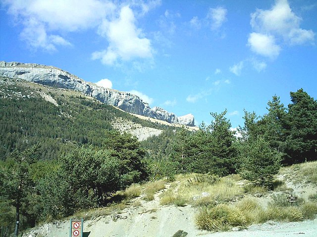
Manteyer is a charming village located in the Hautes-Alpes region of France, offering a variety of hiking opportunities that cater to different skill levels and interests. The area is characterized by its stunning natural landscapes, including rolling hills, forests, and panoramic views of the surrounding Alpine terrain.
Popular Hiking Trails:
-
Les Crêtes de Manteyer: This trail offers a moderate hike with beautiful views of the surrounding mountains and valleys. It is ideal for those who want a rewarding walking experience without extreme difficulty.
-
Le Pic de Bure: For more experienced hikers, the ascent to Pic de Bure provides a challenging trek with breathtaking panoramic vistas at the summit. The trail often involves rocky terrain and can be steep in sections, so good footwear and preparation are essential.
-
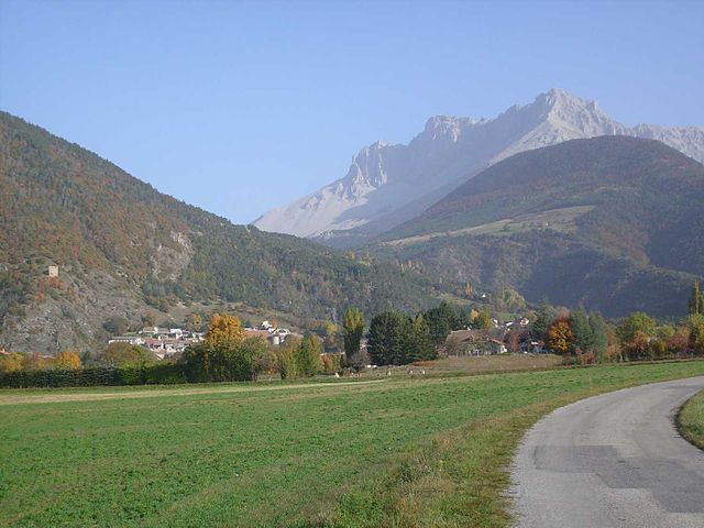
Lac de Pelleautier: This area features a more casual and family-friendly hike around the scenic Lac de Pelleautier. The loop offers lovely views and opportunities for picnicking by the lake, making it a great choice for families or those looking for a leisurely day out.
Tips for Hiking in Manteyer:
- Weather: Always check the weather forecast before heading out, as conditions in the Alps can change rapidly.
- Gear: Wear suitable hiking shoes with good grip, and bring plenty of water and snacks. A map or GPS device can also be beneficial to stay on track.
- Respect Nature: Follow the Leave No Trace principles to keep the environment pristine. Stick to marked trails and avoid disturbing wildlife.
- Local Regulations: Be aware of any local regulations or habitat protection guidelines, especially in national parks or protected areas.
Accessibility:
Manteyer is usually accessible by road, and it can serve as a great base for exploring the wider Hautes-Alpes area. Nearby towns such as Gap offer additional amenities and services for hikers.
Conclusion:
Hiking in Manteyer offers a fantastic mix of stunning scenery, diverse trails, and a chance to experience the tranquility of the French Alps. Whether you're an experienced hiker or a casual walker, there's something for everyone in this beautiful region. Remember to prepare adequately and enjoy the natural beauty that Manteyer has to offer!
- Страна:

- Почтовый код: 05400
- Координаты: 44° 32' 16" N, 5° 57' 50" E


- GPS треки (wikiloc): [Ссылка]
- Площадь: 25.63 кв.км
- Население: 424
- Веб сайт: http://mairie-manteyer.fr/
- Википедия русская: wiki(ru)
- Википедия английская: wiki(en)
- Википедия национальная: wiki(fr)
- Хранилище Wikidata: Wikidata: Q1087608
- Катеория в википедии: [Ссылка]
- код Freebase: [/m/03mfmsj]
- код Freebase: [/m/03mfmsj]
- код GeoNames: Альт: [6446652]
- код GeoNames: Альт: [6446652]
- номер SIREN: [210500757]
- номер SIREN: [210500757]
- код муниципалитета INSEE: 05075
- код муниципалитета INSEE: 05075
Граничит с регионами:
Шатонёф-д’Оз
- коммуна во Франции
Hiking in Шатонёф-д’Оз
Châteauneuf-d'Oze is a charming village located in the Hautes-Alpes region of southeastern France. Nestled in the picturesque Oisans area, it's surrounded by stunning mountain scenery, making it an attractive destination for hikers. Here are some highlights and tips for hiking in and around Châteauneuf-d'Oze:...
- Страна:
- Почтовый код: 05400
- Координаты: 44° 30' 42" N, 5° 51' 53" E
- GPS треки (wikiloc): [Ссылка]
- Площадь: 26.23 кв.км
- Население: 27

Пеллотье
- коммуна во Франции
Hiking in Пеллотье
Pelleautier is a beautiful commune located in the Hautes-Alpes region of southeastern France. Nestled near the foot of the Écrins mountains and close to the city of Gap, it offers a range of hiking opportunities that cater to various skill levels....
- Страна:
- Почтовый код: 05000
- Координаты: 44° 31' 1" N, 6° 1' 0" E
- GPS треки (wikiloc): [Ссылка]
- Площадь: 12.81 кв.км
- Население: 684

Ла-Рош-дез-Арно
- коммуна во Франции
Hiking in Ла-Рош-дез-Арно
La Roche-des-Arnauds is a charming commune in the Hautes-Alpes department of southeastern France, known for its stunning natural landscapes and outdoor recreational opportunities, including hiking. Here are some key points to consider if you're planning to hike in this area:...
- Страна:
- Почтовый код: 05400
- Координаты: 44° 33' 48" N, 5° 57' 23" E
- GPS треки (wikiloc): [Ссылка]
- Площадь: 53.75 кв.км
- Население: 1498

Ла-Фрессинуз
- коммуна во Франции
Hiking in Ла-Фрессинуз
La Freissinouse is a charming village located in the Hautes-Alpes department of southeastern France, nestled in the heart of the French Alps. The region is known for its stunning natural beauty, making it a great destination for hiking enthusiasts....
- Страна:
- Почтовый код: 05000
- Координаты: 44° 32' 5" N, 6° 0' 35" E
- GPS треки (wikiloc): [Ссылка]
- Площадь: 8.32 кв.км
- Население: 786
Монмор
- коммуна во Франции
Hiking in Монмор
Montmaur, located in the Hautes-Alpes department of France, offers a range of hiking opportunities for outdoor enthusiasts. Nestled in the picturesque French Alps, this area is characterized by stunning landscapes, diverse flora and fauna, and a variety of trails suitable for different skill levels....
- Страна:
- Почтовый код: 05400
- Координаты: 44° 34' 16" N, 5° 52' 27" E
- GPS треки (wikiloc): [Ссылка]
- Площадь: 48.77 кв.км
- Население: 515