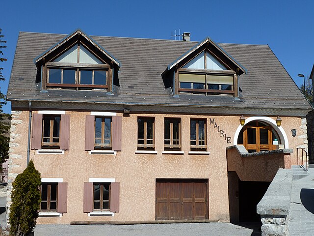
Ла-Рош-дез-Арно (La Roche-des-Arnauds, La Roche-des-Arnauds)
- коммуна во Франции
 Hiking in Ла-Рош-дез-Арно
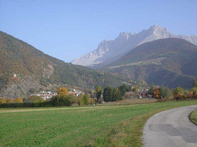
La Roche-des-Arnauds is a charming commune in the Hautes-Alpes department of southeastern France, known for its stunning natural landscapes and outdoor recreational opportunities, including hiking. Here are some key points to consider if you're planning to hike in this area:
Trails and Terrain
- Scenic Routes: The area offers a variety of hiking trails that showcase the breathtaking landscapes of the Southern Alps. You can expect to find trails that wind through lush forests, rocky outcrops, and meadows dotted with wildflowers.
- Difficulty Levels: There are hikes suitable for all skill levels, from easy walks for families to more challenging routes for experienced hikers. Always check trail difficulty before setting out.
Points of Interest
- Natural Beauty: Hikers can enjoy panoramic views of the surrounding mountains and valleys. The area is rich in biodiversity, and you may encounter various wildlife along your trek.
- Cultural Sites: La Roche-des-Arnauds is steeped in history, and you might come across old shepherd huts, stone fences, and remnants of ancient pathways alongside your hiking adventures.
Best Times to Hike
- Season: The best time for hiking in this region is generally in the late spring through early fall (May to September), when the weather is milder and trails are more accessible.
- Weather Conditions: Always check the weather forecast before you go, as conditions can change rapidly in mountainous areas.
Equipment and Preparation
- Footwear: Wear sturdy hiking boots with good traction, as the trails can be rocky and uneven.
- Supplies: Bring plenty of water, snacks, a first-aid kit, and a map or GPS device. It’s also advisable to have layers of clothing to adjust to changing temperatures.
Local Regulations
- Respect Nature: Follow Leave No Trace principles—pack out what you pack in, stay on marked trails, and be mindful of wildlife.
- Check Local Guidelines: Before you hike, ensure that you are aware of any specific regulations or guidelines in place in La Roche-des-Arnauds, including any restrictions on certain trails.
By taking these factors into account, you can enjoy a safe and memorable hiking experience in La Roche-des-Arnauds. Happy hiking!
- Страна:

- Почтовый код: 05400
- Координаты: 44° 33' 48" N, 5° 57' 23" E


- GPS треки (wikiloc): [Ссылка]
- Площадь: 53.75 кв.км
- Население: 1498
- Википедия русская: wiki(ru)
- Википедия английская: wiki(en)
- Википедия национальная: wiki(fr)
- Хранилище Wikidata: Wikidata: Q1364607
- Катеория в википедии: [Ссылка]
- код Freebase: [/m/03mfpcy]
- код Freebase: [/m/03mfpcy]
- код GeoNames: Альт: [6455467]
- код GeoNames: Альт: [6455467]
- номер SIREN: [210501235]
- номер SIREN: [210501235]
- код LCNAF: Альт: [n88643594]
- код LCNAF: Альт: [n88643594]
- код муниципалитета INSEE: 05123
- код муниципалитета INSEE: 05123
Граничит с регионами:

Мантейе
- коммуна во Франции
Hiking in Мантейе
Manteyer is a charming village located in the Hautes-Alpes region of France, offering a variety of hiking opportunities that cater to different skill levels and interests. The area is characterized by its stunning natural landscapes, including rolling hills, forests, and panoramic views of the surrounding Alpine terrain....
- Страна:
- Почтовый код: 05400
- Координаты: 44° 32' 16" N, 5° 57' 50" E
- GPS треки (wikiloc): [Ссылка]
- Площадь: 25.63 кв.км
- Население: 424
- Веб сайт: [Ссылка]

Гап
- коммуна во Франции
Hiking in Гап
Gap, located in the Hautes-Alpes region of southeastern France, is a wonderful destination for hiking enthusiasts. Surrounded by majestic mountains and alpine landscapes, it offers a variety of trails that cater to all levels of hikers, from beginners to experienced trekkers....
- Страна:
- Почтовый код: 05000
- Координаты: 44° 33' 31" N, 6° 4' 40" E
- GPS треки (wikiloc): [Ссылка]
- Площадь: 110.43 кв.км
- Население: 40776
- Веб сайт: [Ссылка]
Деволюи
- коммуна во Франции
Hiking in Деволюи
Le Dévoluy is a stunning mountain range located in the French Alps, known for its diverse landscapes, breathtaking scenery, and extensive hiking opportunities. Whether you're an experienced hiker or a beginner, there's something for everyone in this area....
- Страна:
- Почтовый код: 05250
- Координаты: 44° 41' 33" N, 5° 56' 28" E
- GPS треки (wikiloc): [Ссылка]
- Площадь: 186.37 кв.км
- Население: 1011
- Веб сайт: [Ссылка]

Ла-Фрессинуз
- коммуна во Франции
Hiking in Ла-Фрессинуз
La Freissinouse is a charming village located in the Hautes-Alpes department of southeastern France, nestled in the heart of the French Alps. The region is known for its stunning natural beauty, making it a great destination for hiking enthusiasts....
- Страна:
- Почтовый код: 05000
- Координаты: 44° 32' 5" N, 6° 0' 35" E
- GPS треки (wikiloc): [Ссылка]
- Площадь: 8.32 кв.км
- Население: 786

Рабу
- коммуна во Франции
Hiking in Рабу
Rabou is a charming village located in the French Alps, specifically within the Hautes-Alpes region. It is surrounded by stunning natural landscapes, making it an excellent destination for hiking enthusiasts. Here’s what you need to know about hiking in and around Rabou:...
- Страна:
- Почтовый код: 05400
- Координаты: 44° 35' 28" N, 6° 0' 20" E
- GPS треки (wikiloc): [Ссылка]
- Площадь: 26.56 кв.км
- Население: 77
Монмор
- коммуна во Франции
Hiking in Монмор
Montmaur, located in the Hautes-Alpes department of France, offers a range of hiking opportunities for outdoor enthusiasts. Nestled in the picturesque French Alps, this area is characterized by stunning landscapes, diverse flora and fauna, and a variety of trails suitable for different skill levels....
- Страна:
- Почтовый код: 05400
- Координаты: 44° 34' 16" N, 5° 52' 27" E
- GPS треки (wikiloc): [Ссылка]
- Площадь: 48.77 кв.км
- Население: 515

Сент-Этьен-ан-Деволюи
- коммуна во Франции
Hiking in Сент-Этьен-ан-Деволюи
Saint-Étienne-en-Dévoluy is a lovely destination for hiking, located in the Dévoluy massif in the French Alps. This area offers a variety of trails suitable for all levels, from gentle walks to more challenging hikes, making it a perfect place for both beginners and experienced hikers....
- Страна:
- Почтовый код: 05250
- Координаты: 44° 41' 36" N, 5° 56' 31" E
- GPS треки (wikiloc): [Ссылка]
- Население: 525
- Веб сайт: [Ссылка]