Монмор (Montmaur, Montmaur)
- коммуна во Франции
 Hiking in Монмор
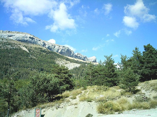
Montmaur, located in the Hautes-Alpes department of France, offers a range of hiking opportunities for outdoor enthusiasts. Nestled in the picturesque French Alps, this area is characterized by stunning landscapes, diverse flora and fauna, and a variety of trails suitable for different skill levels.
Hiking Trails
-
Local Trails: There are several well-marked local trails that cater to both beginners and experienced hikers. These trails often lead through forests, past rivers, and up to scenic viewpoints.
-
GR Hiking Routes: The GR (Grande Randonnée) routes are long-distance trails that traverse the region and can be explored in sections. For instance, GR50 passes through the area, connecting various mountain ranges and offering breathtaking panoramas.
-
Mountain Climbing: For the more adventurous, Montmaur is close to several peaks that offer climbing opportunities. Ensure you're prepared for the technical challenges, and always check local conditions.
Scenic Features
- Dramatic Views: Many trails in the region provide spectacular views of the surrounding mountains and valleys, especially during sunrise and sunset.
- Wildlife: Keep an eye out for local wildlife, including chamois and various bird species, as you hike through their natural habitats.
- Cultural Sites: In addition to hiking, you can explore nearby historical sites and charming villages, which add to the cultural experience of your hike.
Best Time to Hike
The best months for hiking in Montmaur typically range from late spring to early fall (May to September). This period offers mild weather and reduced snow cover on higher trails. If you plan to hike during the summer months, be prepared for possible heat, and make sure to stay hydrated.
Preparation Tips
- Guide Maps: Consider obtaining a hiking map or using navigation apps that cover the local area. The trails are often well-marked, but having a map is always helpful.
- Gear: Ensure you wear appropriate hiking footwear, and bring essential gear such as water, snacks, a first-aid kit, and sunscreen.
- Weather Conditions: Check the weather forecast before you head out, as conditions can change rapidly in the mountains.
Local Resources
You might find local tourist offices helpful for trail maps, information on guided hikes, and current conditions in the area. Engaging with local hiking clubs or groups can also enhance your experience.
Hiking in Montmaur offers a fantastic way to experience the natural beauty and tranquility of the Hautes-Alpes region. Enjoy your adventure!
- Страна:

- Почтовый код: 05400
- Координаты: 44° 34' 16" N, 5° 52' 27" E


- GPS треки (wikiloc): [Ссылка]
- Площадь: 48.77 кв.км
- Население: 515
- Википедия русская: wiki(ru)
- Википедия английская: wiki(en)
- Википедия национальная: wiki(fr)
- Хранилище Wikidata: Wikidata: Q735356
- Катеория в википедии: [Ссылка]
- код Freebase: [/m/03m81dq]
- код Freebase: [/m/03m81dq]
- код GeoNames: Альт: [6446662]
- код GeoNames: Альт: [6446662]
- номер SIREN: [210500872]
- номер SIREN: [210500872]
- код муниципалитета INSEE: 05087
- код муниципалитета INSEE: 05087
Граничит с регионами:
Шатонёф-д’Оз
- коммуна во Франции
Hiking in Шатонёф-д’Оз
Châteauneuf-d'Oze is a charming village located in the Hautes-Alpes region of southeastern France. Nestled in the picturesque Oisans area, it's surrounded by stunning mountain scenery, making it an attractive destination for hikers. Here are some highlights and tips for hiking in and around Châteauneuf-d'Oze:...
- Страна:
- Почтовый код: 05400
- Координаты: 44° 30' 42" N, 5° 51' 53" E
- GPS треки (wikiloc): [Ссылка]
- Площадь: 26.23 кв.км
- Население: 27

Аньер-ан-Деволюи
- коммуна во Франции
Hiking in Аньер-ан-Деволюи
Agnières-en-Dévoluy is a beautiful village located in the Dévoluy mountain range in the French Alps. This region is known for its stunning landscapes, diverse flora and fauna, and a variety of hiking trails that cater to different skill levels. Here are some key points about hiking in Agnières-en-Dévoluy:...
- Страна:
- Почтовый код: 05250
- Координаты: 44° 41' 42" N, 5° 52' 56" E
- GPS треки (wikiloc): [Ссылка]
- Население: 287
- Веб сайт: [Ссылка]

Ла-Клюз
- коммуна во Франции
Hiking in Ла-Клюз
La Cluse, often referred to as La Cluse and its surrounding areas, is a beautiful destination for hikers looking for scenic views, diverse landscapes, and unique geological features. Located in the Jura region of France, it is characterized by rugged terrain, forests, and panoramic views of both mountains and valleys....
- Страна:
- Почтовый код: 05250
- Координаты: 44° 38' 25" N, 5° 50' 56" E
- GPS треки (wikiloc): [Ссылка]
- Население: 43

Мантейе
- коммуна во Франции
Hiking in Мантейе
Manteyer is a charming village located in the Hautes-Alpes region of France, offering a variety of hiking opportunities that cater to different skill levels and interests. The area is characterized by its stunning natural landscapes, including rolling hills, forests, and panoramic views of the surrounding Alpine terrain....
- Страна:
- Почтовый код: 05400
- Координаты: 44° 32' 16" N, 5° 57' 50" E
- GPS треки (wikiloc): [Ссылка]
- Площадь: 25.63 кв.км
- Население: 424
- Веб сайт: [Ссылка]
Фюрмейе
- коммуна во Франции
Hiking in Фюрмейе
Furmeyer is a fantastic location for hiking enthusiasts, offering a range of trails suited for different skill levels amidst stunning natural scenery. Nestled within a mountainous region, hikers can enjoy diverse landscapes, from lush forests to rocky outcrops, and often breathtaking views....
- Страна:
- Почтовый код: 05400
- Координаты: 44° 32' 11" N, 5° 51' 13" E
- GPS треки (wikiloc): [Ссылка]
- Площадь: 14.27 кв.км
- Население: 143

Ла-Рош-дез-Арно
- коммуна во Франции
Hiking in Ла-Рош-дез-Арно
La Roche-des-Arnauds is a charming commune in the Hautes-Alpes department of southeastern France, known for its stunning natural landscapes and outdoor recreational opportunities, including hiking. Here are some key points to consider if you're planning to hike in this area:...
- Страна:
- Почтовый код: 05400
- Координаты: 44° 33' 48" N, 5° 57' 23" E
- GPS треки (wikiloc): [Ссылка]
- Площадь: 53.75 кв.км
- Население: 1498
Деволюи
- коммуна во Франции
Hiking in Деволюи
Le Dévoluy is a stunning mountain range located in the French Alps, known for its diverse landscapes, breathtaking scenery, and extensive hiking opportunities. Whether you're an experienced hiker or a beginner, there's something for everyone in this area....
- Страна:
- Почтовый код: 05250
- Координаты: 44° 41' 33" N, 5° 56' 28" E
- GPS треки (wikiloc): [Ссылка]
- Площадь: 186.37 кв.км
- Население: 1011
- Веб сайт: [Ссылка]

Аспр-сюр-Бюэш
- коммуна во Франции
Hiking in Аспр-сюр-Бюэш
Aspres-sur-Buëch is a charming commune located in the Hautes-Alpes region of France, offering a range of hiking opportunities amidst stunning natural landscapes. The area is characterized by its picturesque valleys, rugged terrain, and beautiful views of the surrounding mountains. Here are some highlights for hiking around Aspres-sur-Buëch:...
- Страна:
- Почтовый код: 05140
- Координаты: 44° 31' 25" N, 5° 44' 59" E
- GPS треки (wikiloc): [Ссылка]
- Площадь: 42.65 кв.км
- Население: 832

Вейн
- коммуна во Франции
Hiking in Вейн
Veynes, located in the Hautes-Alpes region of France, offers a beautiful setting for hiking enthusiasts. The area is characterized by stunning mountain scenery, varied terrain, and a network of trails suitable for different skill levels. Here are some highlights and tips for hiking in Veynes:...
- Страна:
- Почтовый код: 05400
- Координаты: 44° 32' 3" N, 5° 49' 25" E
- GPS треки (wikiloc): [Ссылка]
- Площадь: 42.6 кв.км
- Население: 3159
- Веб сайт: [Ссылка]

Сент-Этьен-ан-Деволюи
- коммуна во Франции
Hiking in Сент-Этьен-ан-Деволюи
Saint-Étienne-en-Dévoluy is a lovely destination for hiking, located in the Dévoluy massif in the French Alps. This area offers a variety of trails suitable for all levels, from gentle walks to more challenging hikes, making it a perfect place for both beginners and experienced hikers....
- Страна:
- Почтовый код: 05250
- Координаты: 44° 41' 36" N, 5° 56' 31" E
- GPS треки (wikiloc): [Ссылка]
- Население: 525
- Веб сайт: [Ссылка]