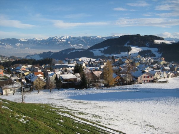
Марбах (Marbach, Marbach SG)

 Hiking in Марбах
Marbach, located in the St. Gallen region of Switzerland, is a beautiful destination for hiking enthusiasts. Nestled in the Alpine foothills, this area offers a variety of trails suited for different skill levels, from easy walks to more challenging hikes. Here are some key points to consider when hiking in Marbach:
Trail Options
-
Panoramaweg Marbach: This is a popular circular trail that provides stunning views of the surrounding mountains and valleys. It’s relatively easy and suitable for families.
-
To the Churfirsten Mountains: For more experienced hikers, trails leading toward the Churfirsten mountain range offer steeper ascents and breathtaking scenery. The ridge offers panoramic views of Lake Zurich and the surrounding Alps.
-
The Ridge Walk: A more challenging option that might include traversing along the ridges, where you can experience the thrill of hiking in a more rugged terrain.
Nature and Wildlife
The region is rich in flora and fauna, providing opportunities to observe various wildlife, including deer and numerous bird species. The lush meadows and forests add to the natural beauty of the area, especially during spring and summer months when wildflowers bloom.
Hiking Tips
- Weather: Always check the weather forecast before heading out. Conditions can change rapidly in the mountains.
- Footwear: Proper hiking boots are essential, as many trails can be rocky and uneven.
- Water and Snacks: Keep hydrated and pack snacks for energy, especially on longer hikes.
- Maps and Navigation: Although trails are often well-marked, it’s advisable to carry a map or a GPS device for navigation, particularly if you’re exploring less popular routes.
Getting There
Marbach can be accessed by public transport or car, with parking options available. If you’re using public transportation, check the local schedules for buses or trains that service the area.
Safety Considerations
As with any hiking adventure, be mindful of your own fitness level, plan your route, and inform someone about your hike. If venturing into remote areas, consider carrying a first-aid kit and emergency gear.
Local Accommodations
There are options for accommodations in and around Marbach, ranging from guesthouses to hotels, allowing you to enjoy multi-day hiking itineraries.
Ultimately, hiking in Marbach offers a wonderful opportunity to immerse oneself in the serene Swiss landscape while enjoying various trails that highlight the natural beauty of the St. Gallen region.
- Страна:

- Почтовый код: 9437
- Телефонный код: 071
- Код автомобильного номера: SG
- Координаты: 47° 23' 30" N, 9° 34' 5" E


- GPS треки (wikiloc): [Ссылка]
- Высота над уровнем моря: 413 м m
- Площадь: 4.42 кв.км
- Население: 2055
- Веб сайт: http://www.marbach.ch
- Википедия русская: wiki(ru)
- Википедия английская: wiki(en)
- Википедия национальная: wiki(de)
- Хранилище Wikidata: Wikidata: Q67900
- Катеория в википедии: [Ссылка]
- код Freebase: [/m/0gmf_l]
- код GeoNames: Альт: [7286434]
- ID отношения в OpenStreetMap: [1683905]
- идентификатор HDS: [1342]
- код швейцарского муниципалитета: [3253]
Граничит с регионами:


Ребштайн
Hiking in Ребштайн
Rebstein is a small municipality located in the canton of St. Gallen in Switzerland, known for its beautiful landscapes and proximity to various hiking trails. Its location near the Rhine River and the foothills of the Alps offers hikers a diverse range of experiences....
- Страна:
- Почтовый код: 9445
- Телефонный код: 071
- Код автомобильного номера: SG
- Координаты: 47° 23' 37" N, 9° 35' 23" E
- GPS треки (wikiloc): [Ссылка]
- Высота над уровнем моря: 410 м m
- Площадь: 4.26 кв.км
- Население: 4387
- Веб сайт: [Ссылка]


Оберрит
Hiking in Оберрит
Oberriet, located in the picturesque region of eastern Switzerland, offers a unique hiking experience characterized by stunning landscapes, charming villages, and a variety of trails suitable for different skill levels. Here are some key points to consider for hiking in Oberriet:...
- Страна:
- Почтовый код: 9463
- Телефонный код: 071
- Код автомобильного номера: SG
- Координаты: 47° 20' 6" N, 9° 33' 49" E
- GPS треки (wikiloc): [Ссылка]
- Высота над уровнем моря: 421 м m
- Площадь: 34.51 кв.км
- Население: 8839
- Веб сайт: [Ссылка]


Ройте
Hiking in Ройте
Reute is a beautiful area located in Germany, particularly noted for its picturesque landscapes and hiking opportunities. Here are some key points about hiking in Reute:...
- Страна:
- Почтовый код: 9411
- Телефонный код: 071
- Код автомобильного номера: AR
- Координаты: 47° 25' 10" N, 9° 34' 30" E
- GPS треки (wikiloc): [Ссылка]
- Высота над уровнем моря: 703 м m
- Площадь: 4.99 кв.км
- Население: 690
- Веб сайт: [Ссылка]


Альтштеттен
Hiking in Альтштеттен
Altstätten, located in the eastern part of Switzerland, is a charming town nestled near the Appenzell region, offering a variety of hiking opportunities that cater to all levels of hikers. The surrounding landscape is characterized by rolling hills, lush forests, and stunning mountain views, making it a fantastic destination for outdoor enthusiasts....
- Страна:
- Почтовый код: 9450
- Телефонный код: 071
- Код автомобильного номера: SG
- Координаты: 47° 22' 41" N, 9° 32' 56" E
- GPS треки (wikiloc): [Ссылка]
- Высота над уровнем моря: 465 м m
- Площадь: 39.11 кв.км
- Население: 11549
- Веб сайт: [Ссылка]
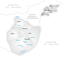
Оберегг
- коммуна в Швейцарии, в кантоне Аппенцелль-Иннерроден
Hiking in Оберегг
Hiking in the Oberegg District, located in the canton of Appenzell Innerrhoden in Switzerland, offers a beautiful blend of scenic landscapes, cultural experiences, and varied terrains. This area is characterized by rolling hills, lush fields, and magnificent views of the surrounding mountains, making it a perfect destination for both novice and experienced hikers....
- Страна:
- Почтовый код: 9413
- Телефонный код: 071
- Код автомобильного номера: AI
- Координаты: 47° 25' 1" N, 9° 33' 27" E
- GPS треки (wikiloc): [Ссылка]
- Высота над уровнем моря: 885 м m
- Площадь: 14.7 кв.км
- Население: 1907
- Веб сайт: [Ссылка]