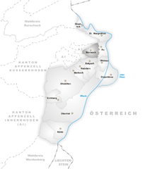
Оберегг (Oberegg, Oberegg AI)

- коммуна в Швейцарии, в кантоне Аппенцелль-Иннерроден
 Hiking in Оберегг
Hiking in the Oberegg District, located in the canton of Appenzell Innerrhoden in Switzerland, offers a beautiful blend of scenic landscapes, cultural experiences, and varied terrains. This area is characterized by rolling hills, lush fields, and magnificent views of the surrounding mountains, making it a perfect destination for both novice and experienced hikers.
Key Highlights of Hiking in Oberegg:
-
Scenic Trails: The region boasts a network of well-maintained hiking trails that cater to different skill levels. Some trails are relatively easy and suitable for families, while others offer more challenging sections for seasoned hikers.
-
Panoramic Views: As you hike through the Oberegg District, you'll be treated to sweeping views of the Appenzell region, including the iconic Alpstein mountains. The vistas are especially breathtaking during sunrise or sunset when the mountains are bathed in golden light.
-
Cultural Experiences: This region is rich in Alpine culture, and hikers can explore traditional Swiss villages, see beautifully maintained farmhouses, and perhaps even meet locals who still engage in age-old farming practices.
-
Flora and Fauna: The diverse ecosystems in the area provide opportunities to encounter a variety of plant species and animals. Birdwatching and spotting local wildlife can add another layer of enjoyment to your hike.
-
Seasonal Hiking: The Oberegg District is accessible year-round, offering different experiences based on the season. In summer, the trails are lush and vibrant, while in winter, snow-covered paths provide opportunities for snowshoeing and winter hiking.
-
Guided Hikes and Tours: For those who prefer a structured experience, local guides offer organized hikes that can provide insights into the natural history and cultural significance of the area.
Essentials for Hiking:
- Trail Maps: It’s advisable to have a detailed hiking map or GPS device to navigate the trails.
- Proper Gear: Wearing sturdy hiking boots and weather-appropriate clothing is crucial, as conditions can vary.
- Hydration and Snacks: Always carry enough water and some snacks to keep your energy levels up during the hike.
- Respect Nature: Practice Leave No Trace principles to help preserve the natural beauty of the area.
Whether you're looking for a leisurely stroll through scenic valleys or a challenging hike up to more elevated terrains, Oberegg District provides a fantastic hiking experience amidst stunning natural beauty and rich cultural heritage. Enjoy your adventure!
- Страна:

- Почтовый код: 9413
- Телефонный код: 071
- Код автомобильного номера: AI
- Координаты: 47° 25' 1" N, 9° 33' 27" E


- GPS треки (wikiloc): [Ссылка]
- Высота над уровнем моря: 885 м m
- Площадь: 14.7 кв.км
- Население: 1907
- Веб сайт: http://www.oberegg.ch
- Википедия русская: wiki(ru)
- Википедия английская: wiki(en)
- Википедия национальная: wiki(de)
- Хранилище Wikidata: Wikidata: Q69407
- Катеория в википедии: [Ссылка]
Граничит с регионами:


Вальценхаузен
Hiking in Вальценхаузен
Walzenhausen, located in Switzerland, is an excellent destination for hiking enthusiasts. Situated in the canton of Appenzell, it offers stunning views of the surrounding landscapes, including the Rhine Valley and the Swiss Alps....
- Страна:
- Почтовый код: 9428
- Телефонный код: 071
- Код автомобильного номера: AR
- Координаты: 47° 26' 37" N, 9° 35' 51" E
- GPS треки (wikiloc): [Ссылка]
- Высота над уровнем моря: 824 м m
- Площадь: 6.98 кв.км
- Население: 1994
- Веб сайт: [Ссылка]


Бальгах
Hiking in Бальгах
Balgach, a small area in Switzerland, may not be as widely known as some of the country’s more famous hiking destinations, but it offers some beautiful landscapes and trails for outdoor enthusiasts. When exploring hiking in and around Balgach, here are a few key points to consider:...
- Страна:
- Почтовый код: 9436
- Телефонный код: 071
- Код автомобильного номера: SG
- Координаты: 47° 24' 3" N, 9° 36' 29" E
- GPS треки (wikiloc): [Ссылка]
- Высота над уровнем моря: 406 м m
- Площадь: 6.52 кв.км
- Население: 4650
- Веб сайт: [Ссылка]


Вольфхальден
Hiking in Вольфхальден
Wolfhalden is a picturesque municipality in the Appenzell Innerrhoden region of Switzerland, surrounded by beautiful landscapes and offering a range of hiking opportunities. Here’s what you need to know about hiking in this area:...
- Страна:
- Почтовый код: 9427
- Телефонный код: 071
- Код автомобильного номера: AR
- Координаты: 47° 26' 59" N, 9° 33' 38" E
- GPS треки (wikiloc): [Ссылка]
- Высота над уровнем моря: 673 м m
- Площадь: 6.95 кв.км
- Население: 1836
- Веб сайт: [Ссылка]


Ройте
Hiking in Ройте
Reute is a beautiful area located in Germany, particularly noted for its picturesque landscapes and hiking opportunities. Here are some key points about hiking in Reute:...
- Страна:
- Почтовый код: 9411
- Телефонный код: 071
- Код автомобильного номера: AR
- Координаты: 47° 25' 10" N, 9° 34' 30" E
- GPS треки (wikiloc): [Ссылка]
- Высота над уровнем моря: 703 м m
- Площадь: 4.99 кв.км
- Население: 690
- Веб сайт: [Ссылка]


Вальд
- община в Швейцарии, Аппенцелль-Ауссерроден
Hiking in Вальд
Wald, located in the Appenzell Ausserrhoden region of Switzerland, offers beautiful hiking opportunities amidst stunning natural landscapes. The area is characterized by rolling hills, vibrant meadows, and picturesque views of the nearby mountains, making it a fantastic destination for both casual walkers and seasoned hikers....
- Страна:
- Почтовый код: 9044
- Телефонный код: 071
- Код автомобильного номера: AR
- Координаты: 47° 24' 56" N, 9° 29' 25" E
- GPS треки (wikiloc): [Ссылка]
- Высота над уровнем моря: 962 м m
- Площадь: 6.82 кв.км
- Население: 857
- Веб сайт: [Ссылка]

Бернек
Hiking in Бернек
Berneck, located in the canton of St. Gallen in Switzerland, offers a beautiful setting for hiking enthusiasts. This small town is nestled along the Rhine River and is surrounded by lush forested hills and scenic landscapes, making it an ideal destination for a variety of hiking experiences....
- Страна:
- Почтовый код: 9442
- Телефонный код: 071
- Код автомобильного номера: SG
- Координаты: 47° 25' 29" N, 9° 36' 45" E
- GPS треки (wikiloc): [Ссылка]
- Высота над уровнем моря: 417 м m
- Площадь: 5.63 кв.км
- Население: 3956
- Веб сайт: [Ссылка]


Марбах
Hiking in Марбах
Marbach, located in the St. Gallen region of Switzerland, is a beautiful destination for hiking enthusiasts. Nestled in the Alpine foothills, this area offers a variety of trails suited for different skill levels, from easy walks to more challenging hikes. Here are some key points to consider when hiking in Marbach:...
- Страна:
- Почтовый код: 9437
- Телефонный код: 071
- Код автомобильного номера: SG
- Координаты: 47° 23' 30" N, 9° 34' 5" E
- GPS треки (wikiloc): [Ссылка]
- Высота над уровнем моря: 413 м m
- Площадь: 4.42 кв.км
- Население: 2055
- Веб сайт: [Ссылка]

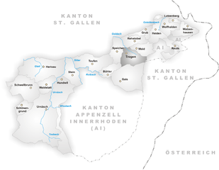
Троген
Hiking in Троген
Trogen is a charming village located in the Appenzell region of Switzerland, surrounded by beautiful landscapes, rolling hills, and stunning views of the Alps. The area is known for its varied hiking trails that cater to all levels of experience, making it an excellent destination for both novice and experienced hikers....
- Страна:
- Почтовый код: 9043
- Телефонный код: 071
- Код автомобильного номера: AR
- Координаты: 47° 24' 27" N, 9° 27' 53" E
- GPS треки (wikiloc): [Ссылка]
- Высота над уровнем моря: 903 м m
- Площадь: 10.02 кв.км
- Население: 1721
- Веб сайт: [Ссылка]


Альтштеттен
Hiking in Альтштеттен
Altstätten, located in the eastern part of Switzerland, is a charming town nestled near the Appenzell region, offering a variety of hiking opportunities that cater to all levels of hikers. The surrounding landscape is characterized by rolling hills, lush forests, and stunning mountain views, making it a fantastic destination for outdoor enthusiasts....
- Страна:
- Почтовый код: 9450
- Телефонный код: 071
- Код автомобильного номера: SG
- Координаты: 47° 22' 41" N, 9° 32' 56" E
- GPS треки (wikiloc): [Ссылка]
- Высота над уровнем моря: 465 м m
- Площадь: 39.11 кв.км
- Население: 11549
- Веб сайт: [Ссылка]


Хайден
- коммуна в кантоне Аппенцелль-Ауссерроден (Швейцария)
Hiking in Хайден
Heiden is a picturesque village located in the Appenzell region of Switzerland, known for its stunning views of Lake Constance and its surrounding mountains. Hiking in and around Heiden offers a range of scenic trails suitable for different skill levels, making it a delightful destination for outdoor enthusiasts. Here are some highlights:...
- Страна:
- Почтовый код: 9410
- Телефонный код: 071
- Код автомобильного номера: AR
- Координаты: 47° 26' 28" N, 9° 31' 52" E
- GPS треки (wikiloc): [Ссылка]
- Высота над уровнем моря: 802 м m
- Площадь: 7.5 кв.км
- Население: 4192
- Веб сайт: [Ссылка]