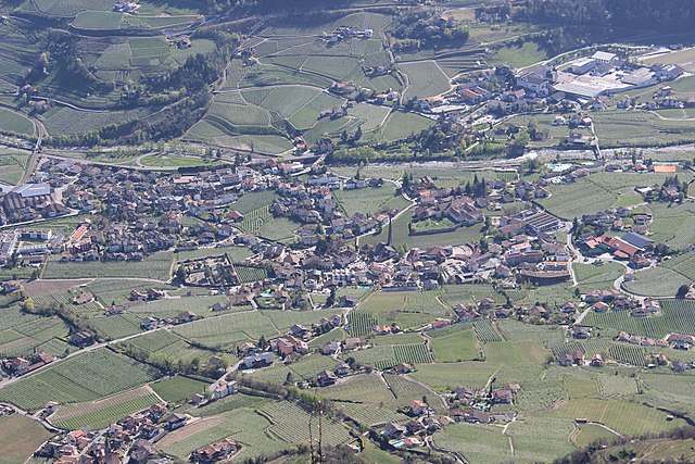
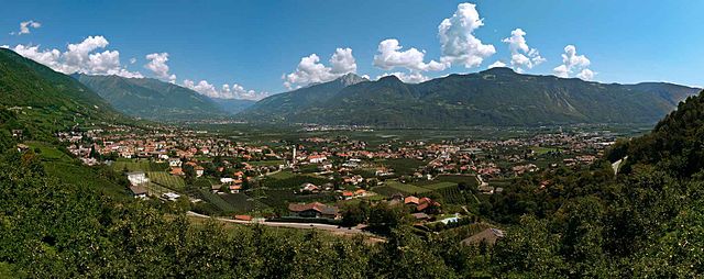
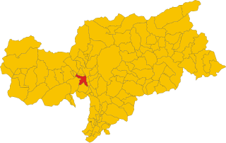
Марленго (Marling, South Tyrol, Marlengo)
.svg)
- коммуна Италии
 Hiking in Марленго
Marling, located in South Tyrol, Italy, is a charming village that offers a plethora of hiking opportunities amidst stunning Alpine scenery. The region is characterized by its mild climate, diverse landscapes, and beautiful panoramic views, making it an ideal destination for both casual walkers and seasoned hikers.
Key Hiking Trails in Marling:
-
Marlinger Waalweg: This is a popular, easy-to-moderate hiking trail that follows the ancient irrigation channels (called "Waal") through lush orchards and forests. The trail offers panoramic views of the surrounding mountains and the Adige Valley, making it a fantastic choice for families and leisurely walks.
-
Taser High Trail: Starting from the cable car station at Taser, this trail offers more challenging hiking options with routes that take you to elevated points for breathtaking views. It's possible to enjoy the natural beauty of the Alpine landscape, including meadows, forests, and rugged mountain scenery.
-
Life on the Waalweg: This thematic trail is a blend of nature and education, showcasing the historical and cultural significance of the Waal irrigation system. It's suitable for all ages and provides informative signs along the route.
Practical Tips:
-
Best Time to Hike: Late spring to early autumn is typically the best time for hiking in South Tyrol, with clear skies and mild temperatures.
-
Gear: Wear appropriate hiking shoes, and bring weather-appropriate clothing, as weather can change rapidly in the Alps. A map or a GPS device can also be very helpful, especially on longer and more remote trails.
-
Hydration and Snacks: Carry plenty of water and some snacks, particularly on longer hikes, as amenities can be sparse in more remote areas.
-
Wildlife: Keep an eye out for local wildlife, which includes various bird species, deer, and other mountain animals.
-
Local Cuisine: After a day of hiking, don't miss the chance to enjoy local South Tyrolean cuisine in one of Marling's charming restaurants. Dishes often feature hearty ingredients like speck, cheese, and dumplings.
Marling serves as a gateway to exploring the greater South Tyrol area, with the added benefit of being less crowded than some more popular hiking destinations. Whether you're interested in leisurely strolls or challenging hikes, Marling offers a delightful hiking experience amidst stunning natural beauty.
- Страна:

- Почтовый код: 39020
- Телефонный код: 0473
- Код автомобильного номера: BZ
- Координаты: 46° 39' 9" N, 11° 8' 44" E


- GPS треки (wikiloc): [Ссылка]
- Высота над уровнем моря: 363 м m
- Площадь: 12.86 кв.км
- Население: 2710
- Веб сайт: http://www.gemeinde.marling.bz.it/
- Википедия русская: wiki(ru)
- Википедия английская: wiki(en)
- Википедия национальная: wiki(it)
- Хранилище Wikidata: Wikidata: Q427354
- Галерея изображений в википедии: [Ссылка]
- Катеория в википедии: [Ссылка]
- код Freebase: [/m/0g9hdt]
- код GeoNames: Альт: [6535908]
- код VIAF: Альт: [140802121]
- ID отношения в OpenStreetMap: [47291]
- код GND: Альт: [4037664-3]
- UN/LOCODE: [ITRNG]
- код ISTAT: 021048
- кадастровый код Италии: E959
Граничит с регионами:


Мерано
- коммуна Италии
Hiking in Мерано
Merano, located in South Tyrol, Italy, is a stunning destination for hiking enthusiasts. Nestled in the mountains, it offers a beautiful combination of alpine scenery, Mediterranean climate, and rich cultural heritage. Here are some highlights about hiking in and around Merano:...
- Страна:
- Почтовый код: 39012
- Телефонный код: 0473
- Код автомобильного номера: BZ
- Координаты: 46° 40' 8" N, 11° 9' 50" E
- GPS треки (wikiloc): [Ссылка]
- Высота над уровнем моря: 325 м m
- Площадь: 26.34 кв.км
- Население: 40047
- Веб сайт: [Ссылка]


Парчинес
- коммуна в Италии
Hiking in Парчинес
Partschins, also known as Parcines, is a beautiful village located in South Tyrol, Italy, right at the foot of the magnificent Texelgruppe Natural Park. This region offers stunning landscapes, diverse trails, and a unique combination of mountain views and lush valley scenery, making it an excellent destination for hikers of all skill levels....
- Страна:
- Почтовый код: 39020
- Телефонный код: 0473
- Код автомобильного номера: BZ
- Координаты: 46° 41' 3" N, 11° 4' 24" E
- GPS треки (wikiloc): [Ссылка]
- Высота над уровнем моря: 3337 м m
- Площадь: 55.4 кв.км
- Население: 3683
- Веб сайт: [Ссылка]


Чермес
- коммуна Италии
Hiking in Чермес
Tscherms, a picturesque village in South Tyrol, Italy, offers a variety of hiking experiences for outdoor enthusiasts. Nestled near the charming town of Merano, it provides access to beautiful trails set against the stunning backdrop of the South Tyrolean Alps....
- Страна:
- Почтовый код: 39010
- Телефонный код: 0473
- Код автомобильного номера: BZ
- Координаты: 46° 37' 58" N, 11° 8' 49" E
- GPS треки (wikiloc): [Ссылка]
- Высота над уровнем моря: 292 м m
- Площадь: 6.62 кв.км
- Население: 1546
- Веб сайт: [Ссылка]

Лагундо
- коммуна Италии
Hiking in Лагундо
Algund, a picturesque village located near Merano in South Tyrol, Italy, is an excellent destination for hiking enthusiasts. It boasts stunning views of the surrounding mountains and valleys, along with diverse trails catering to different skill levels. Here are some highlights of hiking in Algund:...
- Страна:
- Почтовый код: 39022
- Телефонный код: 0473
- Код автомобильного номера: BZ
- Координаты: 46° 41' 0" N, 11° 8' 0" E
- GPS треки (wikiloc): [Ссылка]
- Высота над уровнем моря: 2600 м m
- Площадь: 23.68 кв.км
- Население: 5042
- Веб сайт: [Ссылка]
Лана
- коммуна Италии
Hiking in Лана
Lana, located in South Tyrol, Italy, is a fantastic destination for hiking enthusiasts, offering a diverse range of trails set against stunning alpine scenery. Nestled near the larger town of Merano, Lana provides access to beautiful landscapes, charming villages, and cultural sites....
- Страна:
- Почтовый код: 39011
- Телефонный код: 0473
- Код автомобильного номера: BZ
- Координаты: 46° 37' 0" N, 11° 10' 0" E
- GPS треки (wikiloc): [Ссылка]
- Высота над уровнем моря: 310 м m
- Площадь: 36.12 кв.км
- Население: 12286
- Веб сайт: [Ссылка]