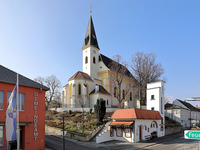
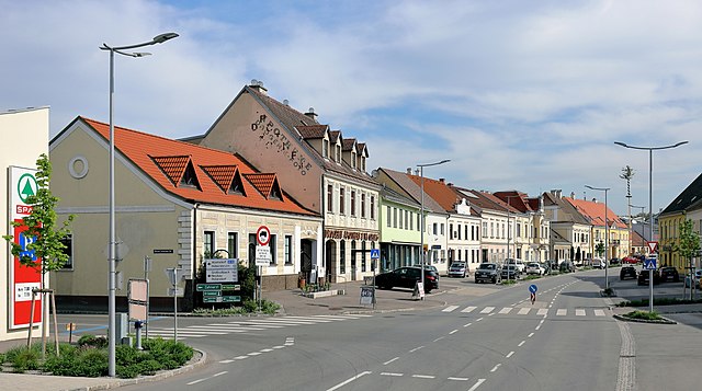
Матцен-Раггендорф (Matzen-Raggendorf, Matzen-Raggendorf)
 Hiking in Матцен-Раггендорф
Matzen-Raggendorf, located in Lower Austria, is a beautiful area for hiking, surrounded by picturesque landscapes, rolling hills, and lush forests. Here’s what you need to know about hiking in this region:
Hiking Trails
-
Scenic Routes: The area offers a variety of trails ranging from easy walks to more challenging hikes. The routes often pass through vineyards, meadows, and wooded areas, providing a diverse hiking experience.
-
Marked Trails: Many trails are well-marked, making navigation straightforward. Look for local signage that indicates the routes and their difficulty levels.
-
Nature Experiences: Along the trails, you can expect to see local fauna and flora, great for those interested in nature photography or birdwatching.
-
Panoramic Views: Some trails lead to elevated points, where you can enjoy panoramic views of the surrounding countryside.
Hiking Seasons
- Spring and Fall: These seasons are particularly lovely for hiking, with moderate temperatures and blooming or changing colors in the foliage.
- Summer: Be prepared for warmer weather; early morning hikes can be refreshing.
- Winter: If you’re an experienced hiker, winter hiking can also be enjoyable, but ensure you have appropriate gear and check trail conditions.
Preparation Tips
- Footwear: Wear comfortable, sturdy hiking boots. The terrain can vary, so good support and grip are essential.
- Hydration and Snacks: Always carry enough water and energy-boosting snacks, especially on longer hikes.
- Weather Check: Before heading out, check the weather forecast and be prepared for sudden changes, as conditions can shift rapidly.
Local Amenities
- Information Centers: Check for local tourist information centers, where you can find maps and additional information about trails and local sights.
- Public Transport: Some areas may be accessible by public transport, making it easier to reach different trailheads.
Safety Considerations
- Always hike with a buddy if possible and let someone know your plans.
- Be aware of your limits regarding distance and elevation gain.
Hiking in Matzen-Raggendorf can be a wonderfully refreshing experience, combining exercise with the beauty of nature. Enjoy your time exploring the trails!
- Страна:

- Почтовый код: 2243
- Телефонный код: 02289
- Код автомобильного номера: GF
- Координаты: 48° 24' 0" N, 16° 42' 0" E


- GPS треки (wikiloc): [Ссылка]
- Высота над уровнем моря: 189 м m
- Площадь: 35.59 кв.км
- Население: 2794
- Веб сайт: http://www.matzen-raggendorf.gv.at
- Википедия русская: wiki(ru)
- Википедия английская: wiki(en)
- Википедия национальная: wiki(de)
- Хранилище Wikidata: Wikidata: Q686420
- Катеория в википедии: [Ссылка]
- код Freebase: [/m/02qttbl]
- код GeoNames: Альт: [7871740]
- код VIAF: Альт: [233903619]
- код австрийского муниципалитета: [30838]
Граничит с регионами:

Хоэнрупперсдорф
Hiking in Хоэнрупперсдорф
Hohenruppersdorf is a charming village located in Austria, specifically in the state of Lower Austria. While it may not be a globally recognized hiking destination, it offers a peaceful natural environment that is great for outdoor enthusiasts who enjoy exploring rural landscapes....
- Страна:
- Почтовый код: 2223
- Телефонный код: 02574
- Код автомобильного номера: GF
- Координаты: 48° 27' 0" N, 16° 39' 0" E
- GPS треки (wikiloc): [Ссылка]
- Высота над уровнем моря: 244 м m
- Площадь: 21.37 кв.км
- Население: 910
- Веб сайт: [Ссылка]

Эбенталь
Hiking in Эбенталь
Ebenthal, located in Lower Austria, offers a variety of hiking opportunities that showcase the region's natural beauty. The landscape features rolling hills, vineyards, and some forested areas, making it an excellent destination for both casual walkers and more experienced hikers....
- Страна:
- Почтовый код: 2251
- Телефонный код: 02538
- Код автомобильного номера: GF
- Координаты: 48° 26' 0" N, 16° 47' 0" E
- GPS треки (wikiloc): [Ссылка]
- Высота над уровнем моря: 176 м m
- Площадь: 18.14 кв.км
- Население: 923
- Веб сайт: [Ссылка]
Ауэрсталь
Hiking in Ауэрсталь
Auersthal, located in Lower Austria, offers a quaint setting for outdoor enthusiasts who enjoy hiking. The region is nestled amidst beautiful landscapes, featuring rolling hills, vineyards, and picturesque views that are characteristic of the broader area....
- Страна:
- Почтовый код: 2214
- Телефонный код: 02288
- Код автомобильного номера: GF
- Координаты: 48° 22' 27" N, 16° 38' 10" E
- GPS треки (wikiloc): [Ссылка]
- Высота над уровнем моря: 178 м m
- Площадь: 15.18 кв.км
- Население: 1932
- Веб сайт: [Ссылка]
Гавайнсталь
Hiking in Гавайнсталь
Gaweinstal is a small village located in the Lower Austria region of Austria, known for its beautiful landscapes and proximity to the natural beauty of the country. While not a major hiking destination like some larger national parks or mountainous areas, Gaweinstal offers several opportunities for outdoor enthusiasts to explore the surrounding countryside. Here’s what you can expect when hiking in this area:...
- Страна:
- Почтовый код: 2191
- Телефонный код: 02574
- Код автомобильного номера: MI
- Координаты: 48° 28' 41" N, 16° 35' 21" E
- GPS треки (wikiloc): [Ссылка]
- Высота над уровнем моря: 199 м m
- Площадь: 51.71 кв.км
- Население: 3947
- Веб сайт: [Ссылка]

Грос-Швайнбарт
Hiking in Грос-Швайнбарт
Groß-Schweinbarth, located in Lower Austria, offers a charming landscape for hiking enthusiasts. The area is characterized by its gentle hills, scenic vineyards, and picturesque countryside, making it a delightful destination for both casual walks and more challenging hikes....
- Страна:
- Почтовый код: 2221
- Телефонный код: 02289
- Код автомобильного номера: GF
- Координаты: 48° 25' 0" N, 16° 38' 0" E
- GPS треки (wikiloc): [Ссылка]
- Высота над уровнем моря: 182 м m
- Площадь: 24.92 кв.км
- Население: 1245
- Веб сайт: [Ссылка]

Шёнкирхен-Райерсдорф
Hiking in Шёнкирхен-Райерсдорф
Schönkirchen-Reyersdorf, located near Vienna, Austria, offers various opportunities for outdoor enthusiasts, including hiking. While it's a small district, its proximity to the scenic landscapes of the region provides hikers with beautiful trails and natural scenery....
- Страна:
- Почтовый код: 2241
- Телефонный код: 02282
- Код автомобильного номера: GF
- Координаты: 48° 21' 0" N, 16° 42' 0" E
- GPS треки (wikiloc): [Ссылка]
- Высота над уровнем моря: 161 м m
- Площадь: 17.88 кв.км
- Население: 1963
- Веб сайт: [Ссылка]

Бад-Пираварт
Hiking in Бад-Пираварт
Bad Pirawarth, located in the northeastern part of Austria, is a quaint village known for its scenic landscapes and outdoor activities, including hiking. The region offers a mix of extensive trails that cater to various skill levels, making it a great destination for both novice and experienced hikers....
- Страна:
- Почтовый код: 2222
- Телефонный код: 02574
- Код автомобильного номера: GF
- Координаты: 48° 27' 7" N, 16° 35' 57" E
- GPS треки (wikiloc): [Ссылка]
- Высота над уровнем моря: 177 м m
- Площадь: 25.42 кв.км
- Население: 1671
- Веб сайт: [Ссылка]

Проттес
Hiking in Проттес
Prottes, a quaint village located in the northeastern part of Austria, offers a range of charming hiking opportunities amidst picturesque landscapes. While not as widely known as other hiking destinations, it provides a unique experience for those looking to explore the natural beauty of the region....
- Страна:
- Почтовый код: 2242
- Телефонный код: 02282
- Код автомобильного номера: GF
- Координаты: 48° 23' 0" N, 16° 44' 0" E
- GPS треки (wikiloc): [Ссылка]
- Высота над уровнем моря: 162 м m
- Площадь: 13.7 кв.км
- Население: 1436
- Веб сайт: [Ссылка]