Гавайнсталь (Gaweinstal, Gaweinstal)
 Hiking in Гавайнсталь
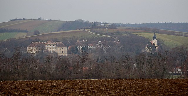
Gaweinstal is a small village located in the Lower Austria region of Austria, known for its beautiful landscapes and proximity to the natural beauty of the country. While not a major hiking destination like some larger national parks or mountainous areas, Gaweinstal offers several opportunities for outdoor enthusiasts to explore the surrounding countryside. Here’s what you can expect when hiking in this area:
Hiking Trails
-
Local Trails: There may be several local paths and trails designated for hiking that meander through the fields and forests surrounding Gaweinstal. These trails can vary in difficulty, from easy walks suitable for families to more challenging hikes for seasoned adventurers.
-
Scenic Views: Hiking in and around Gaweinstal usually provides stunning views of the Austrian countryside, including vineyards, rolling hills, and perhaps some cultural landmarks.
-
Accessibility: The hiking trails are often accessible from the village, and some hikes might lead you to nearby towns or features of interest in the region.
Tips for Hiking in Gaweinstal
- Preparation: Always check the weather before setting out, as it can change quickly in this region. Dress in layers and bring waterproof gear if needed.
- Safety: Make sure to carry enough water and snacks, and let someone know your hiking plans if you're heading out alone or into less populated areas.
- Wildlife and Nature: Be respectful of the natural environment. Keep an eye out for local wildlife, and remember to follow Leave No Trace principles to preserve the area for future hikers.
Nearby Attractions
If you're willing to venture a bit further from Gaweinstal, you can explore the Vienna Woods, the Danube River paths, and other picturesque areas of Lower Austria that offer well-marked trails and additional amenities for hikers.
Conclusion
While Gaweinstal may not have the extensive hiking opportunities found in larger national parks, it provides a charming and serene environment for outdoor activities. Whether you're looking for a peaceful day hike or a leisurely stroll, the rural beauty of Gaweinstal and its surroundings is sure to enhance your hiking experience.
- Страна:

- Почтовый код: 2191
- Телефонный код: 02574
- Код автомобильного номера: MI
- Координаты: 48° 28' 41" N, 16° 35' 21" E


- GPS треки (wikiloc): [Ссылка]
- Высота над уровнем моря: 199 м m
- Площадь: 51.71 кв.км
- Население: 3947
- Веб сайт: http://www.gaweinstal.at/
- Википедия русская: wiki(ru)
- Википедия английская: wiki(en)
- Википедия национальная: wiki(de)
- Хранилище Wikidata: Wikidata: Q666556
- Катеория в википедии: [Ссылка]
- код Freebase: [/m/02qygmz]
- код GeoNames: Альт: [2778772]
- код VIAF: Альт: [248289465]
- код GND: Альт: [4683535-0]
- идентификатор местоположения ArchINFORM: [10091]
- код австрийского муниципалитета: [31612]
Граничит с регионами:

Хоэнрупперсдорф
Hiking in Хоэнрупперсдорф
Hohenruppersdorf is a charming village located in Austria, specifically in the state of Lower Austria. While it may not be a globally recognized hiking destination, it offers a peaceful natural environment that is great for outdoor enthusiasts who enjoy exploring rural landscapes....
- Страна:
- Почтовый код: 2223
- Телефонный код: 02574
- Код автомобильного номера: GF
- Координаты: 48° 27' 0" N, 16° 39' 0" E
- GPS треки (wikiloc): [Ссылка]
- Высота над уровнем моря: 244 м m
- Площадь: 21.37 кв.км
- Население: 910
- Веб сайт: [Ссылка]

Мистельбах-ан-дер-Цайя
Hiking in Мистельбах-ан-дер-Цайя
Mistelbach is a charming town located in the northeastern part of Austria, not far from the border with the Czech Republic. The surrounding area offers a variety of hiking opportunities that allow you to explore the picturesque landscapes of the region....
- Страна:
- Почтовый код: 2130
- Телефонный код: 02572
- Код автомобильного номера: MI
- Координаты: 48° 34' 0" N, 16° 34' 0" E
- GPS треки (wikiloc): [Ссылка]
- Высота над уровнем моря: 190 м m
- Площадь: 131.44 кв.км
- Население: 11559
- Веб сайт: [Ссылка]

Кройцштеттен
Hiking in Кройцштеттен
Kreuzstetten, located in Austria, offers a variety of scenic hiking opportunities for outdoor enthusiasts. While the area itself may not be as widely known as some of the alpine regions, it is surrounded by beautiful landscapes that provide a peaceful environment for hiking....
- Страна:
- Почтовый код: 2124
- Телефонный код: 02263
- Код автомобильного номера: MI
- Координаты: 48° 28' 0" N, 16° 28' 0" E
- GPS треки (wikiloc): [Ссылка]
- Высота над уровнем моря: 224 м m
- Площадь: 24.33 кв.км
- Население: 1541
- Веб сайт: [Ссылка]
Ладендорф
Hiking in Ладендорф
Ladendorf, a charming village in Austria, offers a picturesque setting for hiking enthusiasts. Its location in the Lower Austria region provides access to beautiful landscapes, including rolling hills, vineyards, and forested areas....
- Страна:
- Почтовый код: 2126
- Телефонный код: 02575
- Код автомобильного номера: MI
- Координаты: 48° 32' 0" N, 16° 29' 0" E
- GPS треки (wikiloc): [Ссылка]
- Высота над уровнем моря: 228 м m
- Площадь: 50.05 кв.км
- Население: 2298
- Веб сайт: [Ссылка]

Хохлайтен
Hiking in Хохлайтен
Hochleithen is a picturesque area that offers various hiking opportunities, nestled in the scenic landscapes of Austria. Here’s a brief overview for anyone considering a hiking trip in Hochleithen:...
- Страна:
- Почтовый код: 2123
- Телефонный код: 02245
- Код автомобильного номера: MI
- Координаты: 48° 27' 0" N, 16° 31' 0" E
- GPS треки (wikiloc): [Ссылка]
- Высота над уровнем моря: 226 м m
- Площадь: 19.91 кв.км
- Население: 1166
- Веб сайт: [Ссылка]

Бад-Пираварт
Hiking in Бад-Пираварт
Bad Pirawarth, located in the northeastern part of Austria, is a quaint village known for its scenic landscapes and outdoor activities, including hiking. The region offers a mix of extensive trails that cater to various skill levels, making it a great destination for both novice and experienced hikers....
- Страна:
- Почтовый код: 2222
- Телефонный код: 02574
- Код автомобильного номера: GF
- Координаты: 48° 27' 7" N, 16° 35' 57" E
- GPS треки (wikiloc): [Ссылка]
- Высота над уровнем моря: 177 м m
- Площадь: 25.42 кв.км
- Население: 1671
- Веб сайт: [Ссылка]

Зульц-им-Вайнфиртель
Hiking in Зульц-им-Вайнфиртель
Sulz im Weinviertel, located in the picturesque Weinviertel region of Austria, offers a variety of hiking opportunities that showcase the beauty of its rolling landscapes, vineyards, and charming villages. Here's what you can expect when hiking in this part of Austria:...
- Страна:
- Почтовый код: 2224
- Телефонный код: 02534
- Код автомобильного номера: GF
- Координаты: 48° 29' 0" N, 16° 40' 0" E
- GPS треки (wikiloc): [Ссылка]
- Высота над уровнем моря: 227 м m
- Площадь: 31.37 кв.км
- Население: 1189
- Веб сайт: [Ссылка]

Матцен-Раггендорф
Hiking in Матцен-Раггендорф
Matzen-Raggendorf, located in Lower Austria, is a beautiful area for hiking, surrounded by picturesque landscapes, rolling hills, and lush forests. Here’s what you need to know about hiking in this region:...
- Страна:
- Почтовый код: 2243
- Телефонный код: 02289
- Код автомобильного номера: GF
- Координаты: 48° 24' 0" N, 16° 42' 0" E
- GPS треки (wikiloc): [Ссылка]
- Высота над уровнем моря: 189 м m
- Площадь: 35.59 кв.км
- Население: 2794
- Веб сайт: [Ссылка]