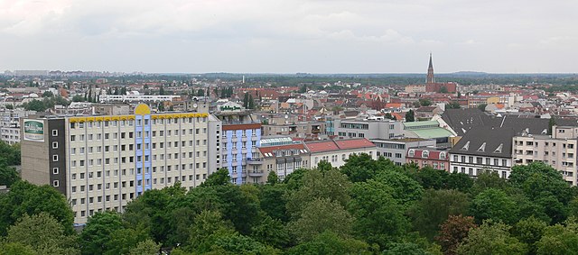
Митте (Mitte, Mitte)

- округ Берлина
 Hiking in Митте
Mitte is a central borough of Berlin, Germany, and while it's better known for its urban environment, historical landmarks, and museums, there are some nearby outdoor opportunities for hiking and nature exploration. Here are a few options for enjoying a hike around Mitte and the surrounding areas:
-
Tiergarten: One of the largest and most famous parks in Berlin, Tiergarten offers a variety of walking paths through wooded areas, gardens, and by the central lake. It’s a great place for a leisurely hike without leaving the city's limits.
-
Tempelhofer Feld: This former airport has been converted into a public park, providing vast open spaces for walking, cycling, and picnicking. While it may not have conventional hiking trails, the expansive area allows for a unique walking experience.
-
Grunewald Forest: Located a bit further from Mitte, this expansive forest offers various trails that can range from leisurely walks to more strenuous hikes. You can explore the nature trails, enjoy the peace of the woodlands, and take in views from the Teufelsberg, a former listening station with panoramic vistas of the city.
-
Müggelberge: A little further afield, the Müggelberge hills are located southeast of Mitte and provide several hiking options. The area is scenic, with lakes, forests, and great lookout points. It’s a wonderful place for a day hike or nature retreat.
-
Sachsenhausen Concentration Camp Memorial: For those looking to combine history with their hiking experience, the memorial site located just outside of Berlin offers walking paths around the grounds, allowing for reflection and contemplation.
-
Parks and Gardens: In and around Mitte, there are several small parks and community gardens where you can enjoy a short walk or a peaceful stroll, including the Volkspark am Friedrichshain and the historic Landschaftspark in the vicinity.
When hiking in urban or semi-urban areas like Mitte, it’s essential to have comfortable walking shoes, stay hydrated, and be mindful of your surroundings. Enjoy your urban hiking adventure in Berlin!
- Страна:

- Координаты: 52° 31' 0" N, 13° 22' 0" E


- GPS треки (wikiloc): [Ссылка]
- Площадь: 39.5 кв.км
- Население: 333905
- Веб сайт: http://www.berlin-mitte.de
- Википедия русская: wiki(ru)
- Википедия английская: wiki(en)
- Википедия национальная: wiki(de)
- Хранилище Wikidata: Wikidata: Q163966
- Галерея изображений в википедии: [Ссылка]
- Катеория в википедии: [Ссылка]
- код Freebase: [/m/022f79]
- код GeoNames: Альт: [2870912]
- код VIAF: Альт: [316878015]
- ID отношения в OpenStreetMap: [16347]
- код GND: Альт: [4248938-6]
- идентификатор местоположения ArchINFORM: [43214]
- код LCNAF: Альт: [n95052133]
- код темы Quora: [Mitte-Berlin]
- код TGN: [1005101]
- код в энциклопедии «Британника онлайн»: [place/Berlin-Mitte]
Включает регионы:


Митте
- район в Берлине в одноимённом округе
Hiking in Митте
Mitte is the central borough of Berlin, Germany, and while it is primarily an urban area known for its historical sites, museums, and vibrant culture, there are still opportunities for outdoor activities, including hiking, especially if you're willing to explore nearby green spaces and parks....
- Страна:
- Почтовый код: 10179; 10178; 10119; 10117; 10115
- Код автомобильного номера: B
- Координаты: 52° 31' 10" N, 13° 24' 24" E
- GPS треки (wikiloc): [Ссылка]
- Высота над уровнем моря: 48 м m
- Площадь: 10.69 кв.км
- Население: 89757


Тиргартен
- район Берлина
Hiking in Тиргартен
Tiergarten is one of the largest and most popular urban parks in Berlin, Germany, and it's a great spot for hiking and outdoor activities. While it's not a traditional hiking destination with rugged trails, it offers an extensive network of paths suitable for leisurely walks, jogging, cycling, and enjoying nature within the city....
- Страна:
- Почтовый код: 10787; 10785; 10557
- Координаты: 52° 31' 0" N, 13° 22' 0" E
- GPS треки (wikiloc): [Ссылка]
- Площадь: 5.17 кв.км
- Население: 13934


Ганзафиртель
- район в Берлине
Hiking in Ганзафиртель
Hansaviertel, located in Berlin, is primarily known for its residential architecture and urban park landscapes rather than traditional hiking trails. However, there are some excellent spots for walking and enjoying the outdoors. Here are some activities you can consider:...
- Страна:
- Почтовый код: 10557; 10555
- Координаты: 52° 31' 0" N, 13° 20' 20" E
- GPS треки (wikiloc): [Ссылка]
- Высота над уровнем моря: 38 м m
- Площадь: 0.53 кв.км
- Население: 5689

Гезундбруннен
- район в Берлине
Hiking in Гезундбруннен
Gesundbrunnen is a neighborhood in Berlin, known more for its urban environment than traditional hiking trails. However, there are options for those looking to enjoy the outdoors and some nature walks in and around the area. Here are a few recommendations:...
- Страна:
- Почтовый код: 13409; 13359; 13357; 13355; 13353; 13347
- Координаты: 52° 32' 55" N, 13° 23' 25" E
- GPS треки (wikiloc): [Ссылка]
- Высота над уровнем моря: 53 м m
- Площадь: 6.13 кв.км
- Население: 90748

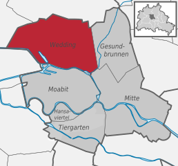
Веддинг
- район Берлина
Hiking in Веддинг
Hiking in Wedding, a district in the borough of Mitte, Berlin, might not be the first thing that comes to mind when you think of hiking, as it is primarily an urban area. However, there are several parks and green spaces within and around Wedding where you can enjoy short hikes or leisurely walks....
- Страна:
- Почтовый код: 13407; 13359; 13357; 13353; 13351; 13349; 13347
- Координаты: 52° 33' 0" N, 13° 22' 0" E
- GPS треки (wikiloc): [Ссылка]
- Высота над уровнем моря: 41 м m
- Площадь: 9.23 кв.км
- Население: 83612

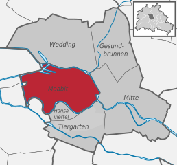
Моабит
- квартал Берлина
Hiking in Моабит
Moabit is a neighborhood in Berlin, Germany, that is known more for its urban landscape than for traditional hiking. However, there are plenty of opportunities for enjoyable walks and exploring green spaces in the area. Here are some suggestions for exploring the outdoors in and around Moabit:...
- Страна:
- Почтовый код: 13353; 10559; 10557; 10555; 10553; 10551
- Координаты: 52° 32' 0" N, 13° 20' 0" E
- GPS треки (wikiloc): [Ссылка]
- Высота над уровнем моря: 40 м m
- Площадь: 7.72 кв.км
- Население: 77344
Граничит с регионами:

Шарлоттенбург-Вильмерсдорф
- округ Берлина
Hiking in Шарлоттенбург-Вильмерсдорф
Charlottenburg-Wilmersdorf is a district in Berlin that, while primarily urban, offers some enjoyable opportunities for hiking and outdoor activities. Here are a few highlights and tips for hiking in and around the area:...
- Страна:
- Координаты: 52° 30' 0" N, 13° 17' 0" E
- GPS треки (wikiloc): [Ссылка]
- Площадь: 64.7 кв.км
- Население: 334351
- Веб сайт: [Ссылка]


Темпельхоф-Шёнеберг
- округ Берлина
Hiking in Темпельхоф-Шёнеберг
Tempelhof-Schöneberg is a unique district in Berlin, known more for its urban environment than traditional hiking trails. However, it does offer opportunities for outdoor activities and scenic walks. Here are some highlights for exploring the area on foot:...
- Страна:
- Координаты: 52° 28' 0" N, 13° 23' 0" E
- GPS треки (wikiloc): [Ссылка]
- Площадь: 531 кв.км
- Веб сайт: [Ссылка]


Райниккендорф
- округ Берлина
Hiking in Райниккендорф
Reinickendorf is a district located in the northern part of Berlin, Germany. While it is primarily an urban area, there are still opportunities for hiking and enjoying nature. Here are some highlights and tips for hiking in Reinickendorf:...
- Страна:
- Координаты: 52° 34' 0" N, 13° 20' 0" E
- GPS треки (wikiloc): [Ссылка]
- Площадь: 89.5 кв.км
- Население: 260253
- Веб сайт: [Ссылка]


Фридрихсхайн-Кройцберг
- округ Берлина
Hiking in Фридрихсхайн-Кройцберг
Friedrichshain-Kreuzberg is a vibrant district in Berlin, known for its rich culture, street art, and diverse communities rather than traditional hiking trails. However, it does offer some great opportunities for walking and exploring. Here are some options for those looking to enjoy urban hiking in this area:...
- Страна:
- Координаты: 52° 30' 0" N, 13° 27' 0" E
- GPS треки (wikiloc): [Ссылка]
- Площадь: 20.2 кв.км
- Население: 281076
- Веб сайт: [Ссылка]

Панков
Hiking in Панков
Pankow is a borough in Berlin, Germany, and while it's primarily known for its urban environment, there are some options for hiking and enjoying nature in the area or nearby. Here are a few suggestions for hiking and outdoor activities around Pankow:...
- Страна:
- Код автомобильного номера: B
- Координаты: 52° 34' 0" N, 13° 24' 0" E
- GPS треки (wikiloc): [Ссылка]
- Площадь: 103 кв.км
- Веб сайт: [Ссылка]