
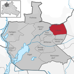
Райниккендорф (Reinickendorf, Reinickendorf)
.svg)
- округ Берлина
 Hiking in Райниккендорф
Reinickendorf is a district located in the northern part of Berlin, Germany. While it is primarily an urban area, there are still opportunities for hiking and enjoying nature. Here are some highlights and tips for hiking in Reinickendorf:
-
Green Spaces: Reinickendorf offers several parks and green spaces where you can explore and enjoy nature. Notable spots include Tegeler Fliess, a small river that offers lovely walking paths and wooded areas.
-
Tegel Forest (Tegeler Forst): Just outside Reinickendorf, this large forest area provides numerous trails for hiking, walking, and cycling. It's a great place to disconnect from urban life and immerse yourself in nature.
-
Lake Tegel: The areas around Lake Tegel offer scenic views and trails. You can hike along the lakeshores or take part in water-related activities in the summer. The area also has picnic spots, making it a nice spot for a day out.
-
Historical Routes: Some trails in and around Reinickendorf may offer insights into the area's history and culture. You might discover old buildings, historical sites, and learn about the local flora and fauna.
-
Accessibility: Given its location in Berlin, many hiking spots in and around Reinickendorf are easily accessible via public transport. This makes it convenient to plan day trips or short hikes.
-
Safety and Preparation: As with any hiking excursion, be sure to wear appropriate footwear, carry sufficient water, and let someone know your planned route. It's also advisable to check the weather beforehand.
-
Local Guides and Organizations: If you're interested in joining guided hikes or organized outdoor activities, consider checking local nature organizations or hiking clubs in Berlin, as they often have scheduled events.
While Reinickendorf may not have extensive wilderness trails like some remote areas, it does provide several opportunities for those looking to enjoy walking and hiking in a green environment within the city.
- Страна:

- Координаты: 52° 34' 0" N, 13° 20' 0" E


- GPS треки (wikiloc): [Ссылка]
- Площадь: 89.5 кв.км
- Население: 260253
- Веб сайт: http://www.berlin.de/ba-reinickendorf
- Википедия русская: wiki(ru)
- Википедия английская: wiki(en)
- Википедия национальная: wiki(de)
- Хранилище Wikidata: Wikidata: Q158876
- Галерея изображений в википедии: [Ссылка]
- Катеория в википедии: [Ссылка]
- код Freebase: [/m/022nhs]
- код GeoNames: Альт: [2848755]
- код VIAF: Альт: [148897149]
- ID отношения в OpenStreetMap: [16334]
- код GND: Альт: [4087337-7]
- идентификатор местоположения ArchINFORM: [43213]
- код LCNAF: Альт: [n50078161]
- код TGN: [1005422]
- код места в Facebook: [107645229258732]
Включает регионы:


Хайлигензе
- район в Берлине
Hiking in Хайлигензе
Heiligensee, located in the northeastern part of Berlin, Germany, is a peaceful and charming area that offers various outdoor activities, including hiking. Here are some key aspects to consider when hiking in Heiligensee:...
- Страна:
- Почтовый код: 13505; 13503
- Координаты: 52° 37' 0" N, 13° 14' 0" E
- GPS треки (wikiloc): [Ссылка]
- Высота над уровнем моря: 39 м m
- Площадь: 10.7 кв.км
- Население: 17834


Конрадсхёэ
- район в Берлине
Hiking in Конрадсхёэ
Konradshöhe is a neighborhood located in the northern part of Berlin, Germany. While it may not be primarily known as a hiking destination, there are some beautiful areas and green spaces nearby that offer opportunities for walking and enjoying nature....
- Страна:
- Почтовый код: 13505
- Координаты: 52° 35' 0" N, 13° 14' 0" E
- GPS треки (wikiloc): [Ссылка]
- Высота над уровнем моря: 39 м m
- Площадь: 2.2 кв.км
- Население: 6029
Любарс
- район в Берлине
Hiking in Любарс
Lübars, located in the northern part of Berlin, Germany, is a charming district that offers beautiful green spaces and opportunities for hiking and outdoor activities. While it may not be as well-known as other hiking destinations, it provides a delightful escape into nature within the city....
- Страна:
- Координаты: 52° 37' 0" N, 13° 22' 0" E
- GPS треки (wikiloc): [Ссылка]
- Высота над уровнем моря: 53 м m
- Площадь: 5 кв.км
- Население: 4969


Виттенау
- район в Берлине
Hiking in Виттенау
Wittenau is a district in the borough of Reinickendorf in Berlin, Germany. While Wittenau itself is primarily urban and residential, it offers some walking and hiking opportunities, especially in nearby parks and natural areas....
- Страна:
- Почтовый код: 13469; 13439; 13437; 13435
- Координаты: 52° 35' 31" N, 13° 19' 35" E
- GPS треки (wikiloc): [Ссылка]
- Высота над уровнем моря: 41 м m
- Площадь: 5.9 кв.км
- Население: 25118

Хермсдорф
- район в Берлине
Hiking in Хермсдорф
Hermsdorf is a charming district located in the northern part of Berlin, surrounded by lush green spaces and natural beauty, making it a great destination for hiking and outdoor activities. While it may not have extensive hiking trails like some larger nature reserves or national parks, there are still various routes and parks nearby that cater to hikers....
- Страна:
- Почтовый код: 13467
- Координаты: 52° 37' 0" N, 13° 19' 0" E
- GPS треки (wikiloc): [Ссылка]
- Высота над уровнем моря: 37 м m
- Площадь: 6.1 кв.км
- Население: 15440


Фронау
- район в Берлине
Hiking in Фронау
Frohnau is a district of the city of Annaberg-Buchholz in the Erzgebirge (Ore Mountains) region of Germany, known for its stunning natural landscapes and rich history. When hiking in Frohnau, you'll have the opportunity to explore beautiful trails, lush forests, and picturesque views....
- Страна:
- Почтовый код: 13465
- Координаты: 52° 38' 0" N, 13° 18' 0" E
- GPS треки (wikiloc): [Ссылка]
- Высота над уровнем моря: 55 м m
- Площадь: 7.8 кв.км
- Население: 16782


Вайдманслуст
- район в Берлине
Hiking in Вайдманслуст
Waidmannslust is a neighborhood located in the northeastern part of Berlin, Germany. While it is primarily a residential area and doesn’t have extensive hiking trails in the traditional sense, there are several nearby locations that offer green spaces and opportunities for walking and light hiking. Here are some options for exploring the area:...
- Страна:
- Координаты: 52° 36' 24" N, 13° 19' 15" E
- GPS треки (wikiloc): [Ссылка]
- Высота над уровнем моря: 47 м m
- Площадь: 2.3 кв.км


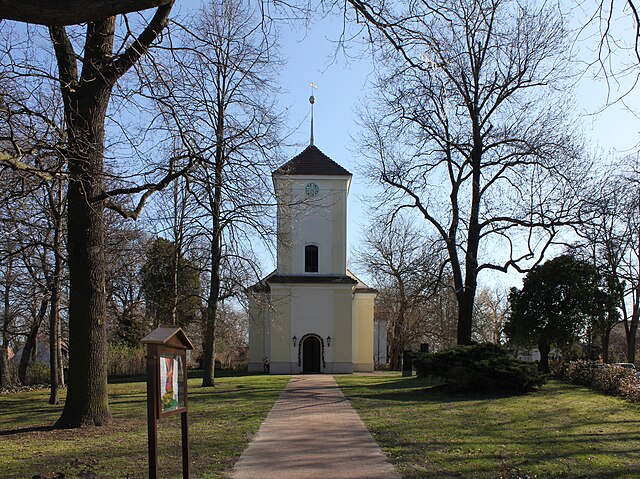
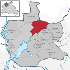
Райниккендорф
- район в одноимённом округе Берлина
Hiking in Райниккендорф
Reinickendorf is a district located in the northern part of Berlin, Germany. While it's primarily an urban area, it offers several opportunities for hiking and outdoor activities, particularly in its parks and natural reserves....
- Страна:
- Почтовый код: 13409; 13407; 13403
- Координаты: 52° 34' 0" N, 13° 20' 0" E
- GPS треки (wikiloc): [Ссылка]
- Высота над уровнем моря: 42 м m
- Площадь: 10.5 кв.км
- Население: 80687


Тегель
- район в Берлине
Hiking in Тегель
Tegel, located in the northern part of Berlin, Germany, is known for its beautiful natural surroundings, including lakes and forests, making it a great area for hiking and outdoor activities. Here are some highlights and tips for hiking in the Tegel area:...
- Страна:
- Почтовый код: 13509; 13507; 13505; 13503; 13405
- Координаты: 52° 35' 0" N, 13° 17' 0" E
- GPS треки (wikiloc): [Ссылка]
- Высота над уровнем моря: 36 м m
- Площадь: 33.7 кв.км
- Население: 35474
Граничит с регионами:


Шпандау
- округ в Берлине
Hiking in Шпандау
Spandau, located in the western part of Berlin, Germany, is an area rich in history and natural beauty, making it a great spot for hiking enthusiasts. While Spandau is more urbanized than many rural hiking areas, there are several parks and natural reserves that offer opportunities for hiking and enjoying the outdoors....
- Страна:
- Почтовый код: 14089; 14052; 13629; 13599; 13597; 13595; 13593; 13591; 13589; 13587; 13585; 13583; 13581
- Координаты: 52° 33' 0" N, 13° 12' 0" E
- GPS треки (wikiloc): [Ссылка]
- Площадь: 91.878 кв.км
- Население: 231120
- Веб сайт: [Ссылка]

Шарлоттенбург-Вильмерсдорф
- округ Берлина
Hiking in Шарлоттенбург-Вильмерсдорф
Charlottenburg-Wilmersdorf is a district in Berlin that, while primarily urban, offers some enjoyable opportunities for hiking and outdoor activities. Here are a few highlights and tips for hiking in and around the area:...
- Страна:
- Координаты: 52° 30' 0" N, 13° 17' 0" E
- GPS треки (wikiloc): [Ссылка]
- Площадь: 64.7 кв.км
- Население: 334351
- Веб сайт: [Ссылка]

Панков
Hiking in Панков
Pankow is a borough in Berlin, Germany, and while it's primarily known for its urban environment, there are some options for hiking and enjoying nature in the area or nearby. Here are a few suggestions for hiking and outdoor activities around Pankow:...
- Страна:
- Код автомобильного номера: B
- Координаты: 52° 34' 0" N, 13° 24' 0" E
- GPS треки (wikiloc): [Ссылка]
- Площадь: 103 кв.км
- Веб сайт: [Ссылка]


Митте
- округ Берлина
Hiking in Митте
Mitte is a central borough of Berlin, Germany, and while it's better known for its urban environment, historical landmarks, and museums, there are some nearby outdoor opportunities for hiking and nature exploration. Here are a few options for enjoying a hike around Mitte and the surrounding areas:...
- Страна:
- Координаты: 52° 31' 0" N, 13° 22' 0" E
- GPS треки (wikiloc): [Ссылка]
- Площадь: 39.5 кв.км
- Население: 333905
- Веб сайт: [Ссылка]