Монтё (Monteux, Monteux)

- коммуна во Франции
 Hiking in Монтё
Monteux, located in the Vaucluse department of the Provence-Alpes-Côte d'Azur region in southern France, is known for its picturesque landscapes and outdoor activities, including hiking. The area is characterized by its beautiful natural surroundings, including vineyards, olive groves, and nearby hills.
Hiking Opportunities in Monteux:
-
Local Trails: Monteux has a variety of local trails that cater to different skill levels. You can enjoy walking paths that meander through the countryside, offering stunning views of the surrounding landscapes and the iconic Mont Ventoux in the distance.
-
Mont Ventoux: While not directly in Monteux, the nearby Mont Ventoux is a popular hiking destination. Known as the "Giant of Provence," it provides a range of trails, from easier walks in the lower slopes to challenging hikes to the summit. The views from the top are breathtaking and well worth the effort.
-
Lac de Monteux: This artificial lake just outside the town offers a scenic spot for a leisurely hike along its shoreline. It’s a great place for families or a more casual hiking experience.
-
Provence Countryside: The surrounding countryside around Monteux is dotted with charming villages and historical sites, providing excellent opportunities for combined hikes that can explore both nature and culture.
Hiking Tips:
-
Trail Maps: Always carry a trail map or GPS device. Local tourist offices may provide maps of the best-known trails.
-
Weather: Check the weather conditions before heading out, particularly in the warmer months when temperatures can rise significantly. Early mornings are often the best time to hike in summer.
-
Footwear: Wear appropriate hiking boots or shoes with good grip, especially on rocky or uneven terrain.
-
Hydration: Bring plenty of water, especially during warmer months, as some trails may lack shade.
Conclusion:
Hiking in Monteux offers a delightful way to experience the natural beauty and cultural heritage of the Provence region. Whether you're a beginner or an experienced hiker, you’ll find trails suited to your level, as well as opportunities to explore the rich landscape and charming villages of this part of France. Enjoy your hike!
- Страна:

- Почтовый код: 84170
- Координаты: 44° 2' 8" N, 4° 59' 50" E


- GPS треки (wikiloc): [Ссылка]
- Площадь: 39.02 кв.км
- Население: 12671
- Веб сайт: http://www.monteux.fr
- Википедия русская: wiki(ru)
- Википедия английская: wiki(en)
- Википедия национальная: wiki(fr)
- Хранилище Wikidata: Wikidata: Q472331
- Катеория в википедии: [Ссылка]
- код Freebase: [/m/02vks0w]
- код GeoNames: Альт: [6451575]
- номер SIREN: [218400802]
- код BNF: [15278060f]
- код VIAF: Альт: [311189356]
- место в MusicBrainz: [045dcbf4-36d3-489e-803f-7e852ff66950]
- WOEID: [612577]
- код муниципалитета INSEE: 84080
Граничит с регионами:

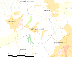
Лориоль-дю-Конта
- коммуна во Франции
Hiking in Лориоль-дю-Конта
Loriol-du-Comtat is a charming village in southeastern France, located in the Vaucluse department of the Provence-Alpes-Côte d'Azur region. This area is known for its beautiful landscapes, picturesque vineyards, and proximity to the southern Rhône Valley. Hiking in and around Loriol-du-Comtat offers a range of scenic trails that cater to different skill levels....
- Страна:
- Почтовый код: 84870
- Координаты: 44° 4' 35" N, 5° 0' 2" E
- GPS треки (wikiloc): [Ссылка]
- Площадь: 11.29 кв.км
- Население: 2570
- Веб сайт: [Ссылка]

Карпантра
- коммуна во Франции
Hiking in Карпантра
Carpentras, located in the Vaucluse department of the Provence-Alpes-Côte d'Azur region in southeastern France, offers a variety of hiking opportunities amidst stunning landscapes. Here are some highlights:...
- Страна:
- Почтовый код: 84200
- Координаты: 44° 3' 18" N, 5° 2' 53" E
- GPS треки (wikiloc): [Ссылка]
- Высота над уровнем моря: 95 м m
- Площадь: 37.92 кв.км
- Население: 28699
- Веб сайт: [Ссылка]


Альтан-де-Палю
- коммуна во Франции
- Страна:
- Почтовый код: 84210
- Код автомобильного номера: 84
- Координаты: 44° 0' 17" N, 4° 57' 30" E
- GPS треки (wikiloc): [Ссылка]
- Площадь: 6.4 кв.км
- Население: 2749
- Веб сайт: [Ссылка]


Бедаррид
- коммуна во Франции
- Страна:
- Почтовый код: 84370
- Координаты: 44° 2' 26" N, 4° 53' 53" E
- GPS треки (wikiloc): [Ссылка]
- Площадь: 24.79 кв.км
- Население: 5051
- Веб сайт: [Ссылка]

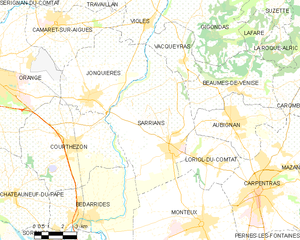
Саррьян
- коммуна во Франции
Hiking in Саррьян
Sarrians is a commune located in the Vaucluse department of the Provence-Alpes-Côte d'Azur region in southeastern France. Surrounded by the beauty of the Provençal countryside, Sarrians offers a variety of hiking opportunities that cater to different levels of experience and preferences....
- Страна:
- Почтовый код: 84260
- Координаты: 44° 5' 0" N, 4° 58' 16" E
- GPS треки (wikiloc): [Ссылка]
- Площадь: 37.49 кв.км
- Население: 5930
- Веб сайт: [Ссылка]


Перн-ле-Фонтен
- коммуна во Франции
Hiking in Перн-ле-Фонтен
Pernes-les-Fontaines, located in the Vaucluse department in the Provence region of France, offers a variety of hiking opportunities. The area is characterized by its stunning natural landscapes, picturesque scenery, and rich cultural heritage. Here are some highlights for hiking in and around Pernes-les-Fontaines:...
- Страна:
- Почтовый код: 84210
- Координаты: 43° 59' 52" N, 5° 3' 33" E
- GPS треки (wikiloc): [Ссылка]
- Площадь: 51.12 кв.км
- Население: 9556
- Веб сайт: [Ссылка]