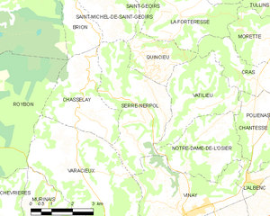
Нотр-Дам-де-л'Озье (Notre-Dame-de-l'Osier, Notre-Dame-de-l'Osier)

- коммуна во Франции
 Hiking in Нотр-Дам-де-л'Озье
Notre-Dame-de-l'Osier, located in the Isère department of France, is a charming village surrounded by stunning natural landscapes, making it an excellent destination for hiking enthusiasts. Here are some highlights:
Scenic Trails
-
Local Hiking Paths: There are several well-marked hiking trails that allow you to explore the captivating landscapes of the region, including vineyards, forests, and stunning views of the surrounding mountains.
-
Mountain Routes: The proximity to the foothills of the Alps offers various trails that range from moderate to challenging, suitable for different skill levels.
Natural Highlights
- Dauphiné Region: The area showcases the beautiful flora and fauna typical of the Dauphiné Alps, with opportunities to spot wildlife and enjoy diverse ecosystems.
- Views: Many trails provide breathtaking views of the Vercors mountain range and other surrounding peaks, making for fantastic photo opportunities.
Practical Considerations
- Weather: Check the weather conditions before heading out, as mountainous areas can have rapidly changing conditions.
- Safety: Always ensure you have the right gear, including sturdy footwear, plenty of water, and a map or GPS device.
Nearby Attractions
- Cultural Sites: After hiking, you might consider visiting the local churches or historical sites in Notre-Dame-de-l'Osier, enhancing your experience of the region’s rich culture.
Conclusion
Hiking in Notre-Dame-de-l'Osier promises a rewarding experience for those looking to immerse themselves in nature and enjoy outdoor activities. Whether you are a seasoned hiker or a beginner, there are options to suit everyone’s abilities. Don’t forget to take in the scenic views and appreciate the serenity of the surroundings.
- Страна:

- Почтовый код: 38470
- Координаты: 45° 14' 18" N, 5° 24' 19" E


- GPS треки (wikiloc): [Ссылка]
- Площадь: 8.38 кв.км
- Население: 478
- Веб сайт: http://notredamedelosier.sud-gresivaudan.org
- Википедия русская: wiki(ru)
- Википедия английская: wiki(en)
- Википедия национальная: wiki(fr)
- Хранилище Wikidata: Wikidata: Q1069006
- Катеория в википедии: [Ссылка]
- код Freebase: [/m/03nvgnp]
- код GeoNames: Альт: [6614876]
- номер SIREN: [213802788]
- код BNF: [15258090z]
- код муниципалитета INSEE: 38278
Граничит с регионами:


Л’Альбенк
- коммуна во Франции
Hiking in Л’Альбенк
L'Albenc is a charming village located in the Auvergne-Rhône-Alpes region of southeastern France. The area surrounding L'Albenc offers a range of hiking opportunities suited for various skill levels, with stunning views of the surrounding mountains and valleys....
- Страна:
- Почтовый код: 38470
- Координаты: 45° 13' 30" N, 5° 26' 26" E
- GPS треки (wikiloc): [Ссылка]
- Площадь: 9.86 кв.км
- Население: 1170
- Веб сайт: [Ссылка]


Ватильё
- коммуна во Франции
Hiking in Ватильё
Vatilieu is a charming commune located in the Isère department in the Auvergne-Rhône-Alpes region of southeastern France. Although it may not be as widely known as other hiking destinations, the surrounding area offers beautiful landscapes and opportunities for outdoor activities like hiking....
- Страна:
- Почтовый код: 38470
- Координаты: 45° 15' 22" N, 5° 24' 38" E
- GPS треки (wikiloc): [Ссылка]
- Площадь: 9.22 кв.км
- Население: 370
- Веб сайт: [Ссылка]


Вине
- коммуна во Франции
Hiking in Вине
Vinay, located in the Isère department of the Auvergne-Rhône-Alpes region in France, is a charming village surrounded by beautiful natural landscapes, making it a great spot for hiking enthusiasts. Here are a few key points to consider when hiking in and around Vinay:...
- Страна:
- Почтовый код: 38470
- Координаты: 45° 12' 36" N, 5° 24' 13" E
- GPS треки (wikiloc): [Ссылка]
- Площадь: 16.01 кв.км
- Население: 4200
- Веб сайт: [Ссылка]

Шантесс
- коммуна во Франции
Hiking in Шантесс
Chantesse, located in the picturesque region of France, offers a variety of hiking opportunities for both beginners and seasoned trekkers. It's nestled in the Vercors massif, which is known for its stunning landscapes, limestone cliffs, and diverse flora and fauna....
- Страна:
- Почтовый код: 38470
- Координаты: 45° 14' 34" N, 5° 26' 40" E
- GPS треки (wikiloc): [Ссылка]
- Площадь: 5.83 кв.км
- Население: 320
- Веб сайт: [Ссылка]

Серр-Нерполь
- коммуна во Франции
Hiking in Серр-Нерполь
Serre-Nerpol, located in the French Alps, offers a range of hiking opportunities for enthusiasts of all skill levels. Here are some key highlights and tips for hiking in this beautiful region:...
- Страна:
- Почтовый код: 38470
- Координаты: 45° 15' 29" N, 5° 22' 30" E
- GPS треки (wikiloc): [Ссылка]
- Высота над уровнем моря: 400 м m
- Площадь: 13.16 кв.км
- Население: 293
- Веб сайт: [Ссылка]