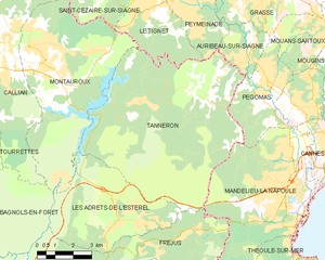
Пегома (Pégomas, Pégomas)
- коммуна в департаменте Приморские Альпы, регион Прованс — Альпы — Лазурный Берег, Франция
 Hiking in Пегома
Pégomas, a quaint commune located in the Alpes-Maritimes department in the French Riviera, offers a range of hiking opportunities that showcase its beautiful natural surroundings. Here are some key points to consider when hiking in the Pégomas area:
Trails and Routes:
-
Varied Terrain: The region features a mix of coastal paths, wooded trails, and mountainous routes. You can find hikes that cater to different skill levels, from easy strolls to more challenging ascents.
-
Nearby Mountains: The nearby Massif de l'Esterel and the foothills of the Alpes offer numerous well-marked trails with stunning views over the Mediterranean Sea, hills, and valleys.
-
Local Parks: Check out the Parc de l'Agay or other natural reserves in the vicinity for well-maintained paths and the chance to see local flora and fauna.
Tips for Hiking in Pégomas:
- Weather Conditions: The Mediterranean climate means mild winters and hot summers. Spring and early autumn can be ideal times for hiking, while summer hikes should start early to avoid the heat.
- Hydration and Supplies: Always carry plenty of water, snacks, and a map or GPS device. While many trails are marked, it’s always best to be prepared.
- Footwear: Sturdy hiking boots or shoes are important due to the rocky and uneven terrain you may encounter.
Points of Interest:
- Scenic Views: Look for viewpoints along the trails that offer panoramic vistas of the coast and surrounding landscapes.
- Wildlife: Keep an eye out for local wildlife, including various species of birds and small mammals.
Safety Considerations:
- Hiking Alone: If you’re new to the area, consider hiking with a partner or as part of a guided group, especially on less populated trails.
- Trail Conditions: Check local resources for current trail conditions, as weather can affect accessibility.
Local Amenities:
Pégomas has local shops and restaurants where you can stock up on supplies or enjoy a meal after your hike. Make sure to explore the charming town itself and experience its local culture.
Conclusion:
Hiking in Pégomas offers a wonderful way to explore the natural beauty of the French Riviera, providing trails suitable for all levels of experience. Always plan ahead and prioritize safety to make the most of your hiking adventures!
- Страна:

- Почтовый код: 06580
- Координаты: 43° 35' 48" N, 6° 56' 0" E


- GPS треки (wikiloc): [Ссылка]
- Площадь: 11.28 кв.км
- Население: 7845
- Веб сайт: http://www.villedepegomas.fr
- Википедия русская: wiki(ru)
- Википедия английская: wiki(en)
- Википедия национальная: wiki(fr)
- Хранилище Wikidata: Wikidata: Q287518
- Катеория в википедии: [Ссылка]
- код Freebase: [/m/03m4_bq]
- код Freebase: [/m/03m4_bq]
- код GeoNames: Альт: [2988220]
- код GeoNames: Альт: [2988220]
- номер SIREN: [210600904]
- номер SIREN: [210600904]
- код BNF: [137555890]
- код BNF: [137555890]
- код VIAF: Альт: [145393952]
- код VIAF: Альт: [145393952]
- код LCNAF: Альт: [no2004013149]
- код LCNAF: Альт: [no2004013149]
- место в MusicBrainz: [a33c950c-8bd4-45aa-a1f1-95da0e2aea82]
- место в MusicBrainz: [a33c950c-8bd4-45aa-a1f1-95da0e2aea82]
- код муниципалитета INSEE: 06090
- код муниципалитета INSEE: 06090
Граничит с регионами:


Грас
- коммуна в департаменте Приморские Альпы, регион Прованс — Альпы — Лазурный Берег, Франция
Hiking in Грас
Grasse, located in the Alpes-Maritimes department in the Provence-Alpes-Côte d'Azur region of France, is famous for its perfume industry and beautiful landscapes. Hiking in and around Grasse offers a range of trails, stunning views, and a chance to experience the rich natural and cultural heritage of the area....
- Страна:
- Почтовый код: 06520; 06130
- Координаты: 43° 39' 29" N, 6° 55' 31" E
- GPS треки (wikiloc): [Ссылка]
- Высота над уровнем моря: 333 м m
- Площадь: 44.44 кв.км
- Население: 50937
- Веб сайт: [Ссылка]


Мандельё-ла-Напуль
- коммуна в департаменте Приморские Альпы, регион Прованс — Альпы — Лазурный Берег, Франция
- Страна:
- Почтовый код: 06210
- Координаты: 43° 32' 44" N, 6° 56' 15" E
- GPS треки (wikiloc): [Ссылка]
- Высота над уровнем моря: 300 м m
- Площадь: 31.37 кв.км
- Население: 22360
- Веб сайт: [Ссылка]

Муан-Сарту
- коммуна в департаменте Приморские Альпы, регион Прованс — Альпы — Лазурный Берег, Франция
Hiking in Муан-Сарту
Mouans-Sartoux is a charming village located in the Alpes-Maritimes department in the Provence-Alpes-Côte d'Azur region of France. It offers attractive hiking opportunities, primarily through its beautiful surroundings and proximity to natural parks and the Mediterranean coastline....
- Страна:
- Почтовый код: 06370
- Координаты: 43° 37' 12" N, 6° 58' 19" E
- GPS треки (wikiloc): [Ссылка]
- Площадь: 13.52 кв.км
- Население: 9510
- Веб сайт: [Ссылка]


Орибо-сюр-Сьянь
- коммуна в департаменте Приморские Альпы, регион Прованс — Альпы — Лазурный Берег, Франция
Hiking in Орибо-сюр-Сьянь
Auribeau-sur-Siagne is a picturesque village located in the Alpes-Maritimes region of France, near the French Riviera. It's nestled in the hills and offers a variety of hiking opportunities that showcase its natural beauty and the surrounding landscape....
- Страна:
- Почтовый код: 06810
- Координаты: 43° 36' 3" N, 6° 54' 40" E
- GPS треки (wikiloc): [Ссылка]
- Площадь: 5.48 кв.км
- Население: 3219
- Веб сайт: [Ссылка]
Ла-Рокет-сюр-Сьянь
- коммуна в департаменте Приморские Альпы, регион Прованс — Альпы — Лазурный Берег, Франция
- Страна:
- Почтовый код: 06550
- Координаты: 43° 34' 48" N, 6° 57' 20" E
- GPS треки (wikiloc): [Ссылка]
- Площадь: 6.31 кв.км
- Население: 5435

Таннерон
- коммуна во Франции
Hiking in Таннерон
Tanneron is a picturesque village located in the Alpes-Maritimes department in the Provence-Alpes-Côte d'Azur region of southeastern France. Known for its stunning natural landscapes, the area offers a variety of hiking opportunities that cater to different experience levels....
- Страна:
- Почтовый код: 83440
- Координаты: 43° 35' 26" N, 6° 52' 32" E
- GPS треки (wikiloc): [Ссылка]
- Площадь: 52.78 кв.км
- Население: 1572