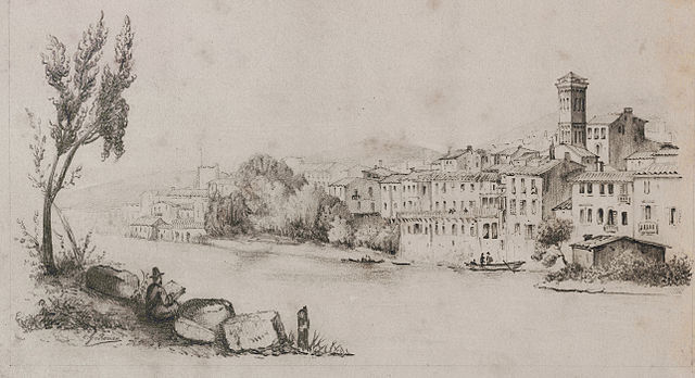
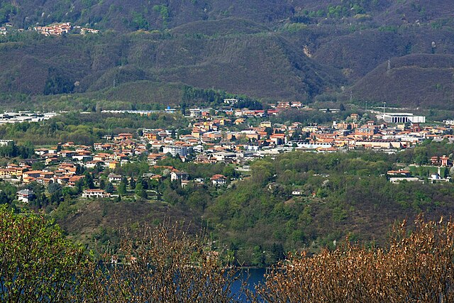
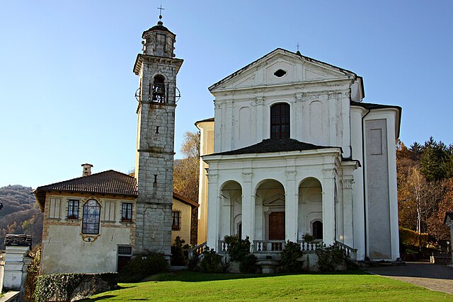
Пелла (Pella, Pella)
- коммуна Италии
 Hiking in Пелла
Pella, located in the Piedmont region of Italy, is surrounded by beautiful landscapes ideal for hiking enthusiasts. The area features rolling hills, scenic vineyards, and woodlands, offering a range of trails suitable for various skill levels. Here are some highlights and tips for hiking in the Pella area:
Hiking Trails
-
Monumento Naturale del Sass della Bionda: This natural monument features trails that wind through stunning rocky landscapes. The routes offer different levels of difficulty, with the opportunity to enjoy panoramic views of the surrounding hills and valleys.
-
Lago d'Orta Loop: Walking along the shores of Lake Orta provides a flat, picturesque route. You can enjoy the tranquility of the lake, and there are numerous spots to pause and take in the views of the islands and villages along the water.
-
Monte Mottarone: Just a short drive from Pella, Monte Mottarone offers a variety of hiking trails with breathtaking views. The trails vary in difficulty and include options for both leisurely walks and more challenging treks. In good weather, you can see both Lake Maggiore and Lake Orta from the summit.
Essential Tips
-
Best Time to Hike: The best months for hiking in the Piedmont region are typically from late spring to early autumn (May to October). The weather is generally pleasant, and the landscape is lush and vibrant.
-
Gear: Wear sturdy hiking shoes, and dress in layers, as temperatures can vary throughout the day. Bring plenty of water and snacks, and don't forget sun protection (hat, sunscreen).
-
Safety: Always inform someone about your hiking plans and expected return time, especially if you're hiking in more remote areas.
-
Local Resources: Check with local tourism offices for maps and specific trail information. They can provide valuable insights and may also offer guided tours.
-
Respect Nature: Stay on marked paths, take all your rubbish with you, and be mindful of local wildlife.
Hiking in Pella not only offers physical activity but also a chance to immerse yourself in the stunning natural beauty and culture of the Piedmont region. Enjoy your hikes!
- Страна:

- Почтовый код: 28010
- Телефонный код: 0322
- Код автомобильного номера: NO
- Координаты: 45° 48' 0" N, 8° 23' 0" E


- GPS треки (wikiloc): [Ссылка]
- Высота над уровнем моря: 305 м m
- Площадь: 8.13 кв.км
- Население: 985
- Веб сайт: http://www.comune.pella.no.it
- Википедия русская: wiki(ru)
- Википедия английская: wiki(en)
- Википедия национальная: wiki(it)
- Хранилище Wikidata: Wikidata: Q22549
- код Freebase: [/m/0g8ts1]
- код GeoNames: Альт: [6538133]
- ID отношения в OpenStreetMap: [46141]
- UN/LOCODE: [ITNVA]
- код ISTAT: 003115
- кадастровый код Италии: G421
Граничит с регионами:
Орта-Сан-Джулио
- коммуна Италии
Hiking in Орта-Сан-Джулио
Orta San Giulio is a picturesque village located on the western shore of Lake Orta in the Piedmont region of northern Italy. The area is renowned for its stunning natural landscapes, charming architecture, and serene atmosphere, making it a wonderful destination for hiking enthusiasts....
- Страна:
- Почтовый код: 28016
- Телефонный код: 0322
- Код автомобильного номера: NO
- Координаты: 45° 48' 0" N, 8° 24' 0" E
- GPS треки (wikiloc): [Ссылка]
- Высота над уровнем моря: 294 м m
- Площадь: 6.65 кв.км
- Население: 1280
- Веб сайт: [Ссылка]

Петтенаско
- коммуна Италии
Hiking in Петтенаско
Pettenasco is a picturesque village located on the shores of Lake Orta in the Piedmont region of northern Italy. The area is characterized by its stunning natural scenery, charming architecture, and a range of outdoor activities, making it an excellent destination for hiking enthusiasts....
- Страна:
- Почтовый код: 28028
- Телефонный код: 0323
- Код автомобильного номера: NO
- Координаты: 45° 48' 0" N, 8° 25' 0" E
- GPS треки (wikiloc): [Ссылка]
- Высота над уровнем моря: 331 м m
- Площадь: 7.07 кв.км
- Население: 1380
- Веб сайт: [Ссылка]
Сан-Маурицио-д'Опальо
- коммуна Италии
Hiking in Сан-Маурицио-д'Опальо
San Maurizio d'Opaglio is a picturesque village located in the Piedmont region of northern Italy, near the shores of Lake Orta. The area is known for its stunning natural beauty, which includes rolling hills, lush forests, and panoramic views of the lake and surrounding mountains. Here's what you can expect when hiking in and around San Maurizio d'Opaglio:...
- Страна:
- Почтовый код: 28017
- Телефонный код: 0322
- Код автомобильного номера: NO
- Координаты: 45° 46' 0" N, 8° 23' 0" E
- GPS треки (wikiloc): [Ссылка]
- Высота над уровнем моря: 373 м m
- Площадь: 8.51 кв.км
- Население: 3075
- Веб сайт: [Ссылка]
Чезара
- коммуна Италии
Hiking in Чезара
Cesara is a charming village located in the Piedmont region of Italy, nestled in the scenic valleys of the Verbano-Cusio-Ossola province. This area offers a wealth of hiking opportunities thanks to its stunning landscapes, lush forests, and panoramic views of the surrounding mountains....
- Страна:
- Почтовый код: 28010
- Телефонный код: 0323
- Код автомобильного номера: VB
- Координаты: 45° 50' 0" N, 8° 22' 0" E
- GPS треки (wikiloc): [Ссылка]
- Высота над уровнем моря: 499 м m
- Площадь: 11.65 кв.км
- Население: 599
- Веб сайт: [Ссылка]
Мадонна-дель-Сассо
- коммуна Италии
Hiking in Мадонна-дель-Сассо
Madonna del Sasso is a picturesque area located in the Piedmont region of northern Italy, near Lake Orta. Known for its stunning landscapes, charming villages, and religious significance, it offers a variety of hiking opportunities suitable for different skill levels. Here are some key aspects to consider when hiking in this area:...
- Страна:
- Почтовый код: 28010
- Телефонный код: 0163; 0322
- Код автомобильного номера: VB
- Координаты: 45° 48' 0" N, 8° 22' 0" E
- GPS треки (wikiloc): [Ссылка]
- Высота над уровнем моря: 696 м m
- Площадь: 15.41 кв.км
- Население: 393
- Веб сайт: [Ссылка]
Нонио
- коммуна Италии
Hiking in Нонио
Nonio is a small municipality located in the Piedmont region of Italy, near Lake Orta, which is known for its stunning natural scenery and outdoor recreational opportunities, including hiking. Here are some highlights if you're considering hiking in Nonio:...
- Страна:
- Почтовый код: 28891
- Телефонный код: 0323
- Код автомобильного номера: VB
- Координаты: 45° 50' 46" N, 8° 22' 39" E
- GPS треки (wikiloc): [Ссылка]
- Высота над уровнем моря: 476 м m
- Площадь: 9.8 кв.км
- Население: 850
- Веб сайт: [Ссылка]