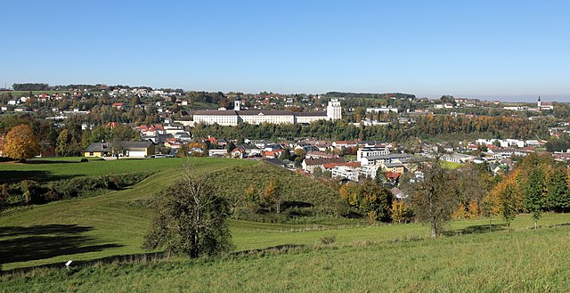
Пфарркирхен-Бад-Халль (Pfarrkirchen bei Bad Hall, Pfarrkirchen bei Bad Hall)
- коммуна в федеральной земле Верхняя Австрия, Австрия
 Hiking in Пфарркирхен-Бад-Халль
Pfarrkirchen bei Bad Hall, located in Austria's Upper Austria region, is a charming area that offers beautiful hiking opportunities. The picturesque landscape, characterized by rolling hills, lush forests, and stunning views of the surrounding mountains, makes it an attractive destination for hikers of all levels.
Hiking Trails
-
Local Trails: There are several marked hiking trails around Pfarrkirchen that vary in length and difficulty, suitable for both beginners and more experienced hikers. Always check the local maps for updated paths and conditions.
-
Bad Hall Region: The nearby Bad Hall also offers additional hiking routes that connect to Pfarrkirchen and can extend your hiking adventure. Trails often lead through vineyards, orchards, and scenic countryside.
-
Hiking Themes: The area may also feature themed hiking trails, such as nature trails, historical paths, or routes that highlight local flora and fauna.
Tips for Hiking in Pfarrkirchen bei Bad Hall
- Weather Considerations: Always check the weather before heading out, as conditions can change quickly in mountainous terrain.
- Proper Gear: Wear suitable hiking boots and pack essentials like water, snacks, a first-aid kit, and a map or GPS device.
- Stay on Marked Trails: To protect local wildlife and plants, stay on marked paths.
- Local Regulations: Familiarize yourself with any local regulations, especially regarding camping or fire use if you plan to extend your stay.
Nearby Attractions
After your hike, consider visiting some local attractions in Bad Hall, such as spas and wellness centers, to relax and unwind. The area is also rich in cultural heritage, with several historical sites to explore.
Conclusion
Pfarrkirchen bei Bad Hall offers an idyllic setting for hiking enthusiasts who enjoy nature, scenic landscapes, and a peaceful atmosphere. Enjoy your hiking adventure!
- Страна:

- Почтовый код: 4540
- Телефонный код: 07258
- Код автомобильного номера: SE
- Координаты: 48° 1' 49" N, 14° 11' 58" E


- GPS треки (wikiloc): [Ссылка]
- Высота над уровнем моря: 397 м m
- Площадь: 11 кв.км
- Население: 2244
- Веб сайт: http://www.pfarrkirchen-badhall.at
- Википедия русская: wiki(ru)
- Википедия английская: wiki(en)
- Википедия национальная: wiki(de)
- Хранилище Wikidata: Wikidata: Q286395
- Катеория в википедии: [Ссылка]
- код Freebase: [/m/03gvc82]
- код GeoNames: Альт: [7872144]
- код VIAF: Альт: [241193924]
- код австрийского муниципалитета: [41511]
Граничит с регионами:

Бад-Халль
- город в федеральной земле Верхняя Австрия, Австрия
Hiking in Бад-Халль
Bad Hall, located in the Upper Austria region, is a charming town known for its spa facilities and beautiful natural landscapes. The surrounding area offers various hiking opportunities that showcase the scenic beauty of the region, including rolling hills, forests, and views of the nearby mountains....
- Страна:
- Почтовый код: 4540
- Телефонный код: 07258
- Код автомобильного номера: SE
- Координаты: 48° 2' 4" N, 14° 12' 35" E
- GPS треки (wikiloc): [Ссылка]
- Высота над уровнем моря: 380 м m
- Площадь: 13.38 кв.км
- Население: 5043
- Веб сайт: [Ссылка]

Адльванг
- коммуна в федеральной земле Верхняя Австрия, Австрия
Hiking in Адльванг
Adlwang is a scenic area located in Austria, particularly known for its beautiful landscapes and outdoor activities, including hiking. The region offers a variety of trails suitable for different skill levels, making it a great destination for both beginners and experienced hikers....
- Страна:
- Почтовый код: 4541
- Телефонный код: 07258
- Код автомобильного номера: SE
- Координаты: 47° 59' 31" N, 14° 13' 4" E
- GPS треки (wikiloc): [Ссылка]
- Высота над уровнем моря: 422 м m
- Площадь: 17 кв.км
- Население: 1806
- Веб сайт: [Ссылка]

Кремсмюнстер
Hiking in Кремсмюнстер
Kremsmünster, located in the Upper Austria region, offers a variety of scenic hiking opportunities. Nestled at the foot of the Alps, this area boasts beautiful landscapes, rich history, and diverse trails suitable for different skill levels. Here’s an overview of what you might experience while hiking in and around Kremsmünster:...
- Страна:
- Почтовый код: 4550
- Телефонный код: 07583
- Код автомобильного номера: KI
- Координаты: 48° 3' 18" N, 14° 7' 51" E
- GPS треки (wikiloc): [Ссылка]
- Высота над уровнем моря: 384 м m
- Площадь: 42.1 кв.км
- Население: 6585
- Веб сайт: [Ссылка]

Вартберг-на-Кремсе
Hiking in Вартберг-на-Кремсе
Wartberg an der Krems is a beautiful village located in Upper Austria, surrounded by stunning landscapes that make it an excellent destination for hiking enthusiasts. The area is characterized by lush forests, rolling hills, and scenic views, making it perfect for various hiking trails suitable for different skill levels....
- Страна:
- Почтовый код: 4552
- Телефонный код: 07587
- Код автомобильного номера: KI
- Координаты: 47° 59' 24" N, 14° 7' 1" E
- GPS треки (wikiloc): [Ссылка]
- Высота над уровнем моря: 385 м m
- Площадь: 31.6 кв.км
- Население: 2993
- Веб сайт: [Ссылка]


Нусбах
Hiking in Нусбах
Nußbach, a small but scenic village in Austria, offers hiking opportunities that allow you to explore the beautiful landscapes of the region. Situated in Upper Austria, near the foothills of the Alps, the area is characterized by rolling hills, lush forests, and breathtaking mountain views....
- Страна:
- Почтовый код: 4542
- Телефонный код: 07587
- Код автомобильного номера: KI
- Координаты: 47° 58' 21" N, 14° 9' 53" E
- GPS треки (wikiloc): [Ссылка]
- Высота над уровнем моря: 464 м m
- Площадь: 30.4 кв.км
- Население: 2286
- Веб сайт: [Ссылка]