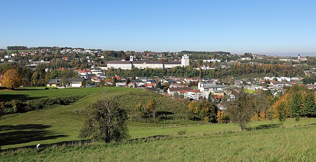
Бад-Халль (Bad Hall, Bad Hall)
- город в федеральной земле Верхняя Австрия, Австрия
 Hiking in Бад-Халль
Bad Hall, located in the Upper Austria region, is a charming town known for its spa facilities and beautiful natural landscapes. The surrounding area offers various hiking opportunities that showcase the scenic beauty of the region, including rolling hills, forests, and views of the nearby mountains.
Hiking Highlights in Bad Hall:
-
Trails and Routes:
- There are numerous well-marked hiking trails suitable for all skill levels. Popular routes often lead through lush woodlands, past picturesque meadows, and along the banks of rivers.
- Some trails may include circular routes, allowing hikers to explore the area without the need for backtracking.
-
Nature and Scenery:
- As you hike, you'll be treated to the beautiful landscapes characteristic of Upper Austria, including panoramic views, serene lakes, and rich biodiversity.
- The area is home to various wildlife, so keep an eye out for birds and other fauna.
-
Spa and Relaxation:
- After a day of hiking, you can take advantage of Bad Hall's famous thermal spas. This is a great way to relax your muscles and rejuvenate after a long hike.
-
Cultural Sites:
- Besides nature, the region also boasts historical landmarks and cultural points of interest, such as traditional farms, charming villages, and local eateries offering regional cuisine.
Tips for Hiking in Bad Hall:
- Preparation: Always check the weather and trail conditions before heading out. Dress in layers and wear sturdy footwear suitable for hiking.
- Stay Hydrated: Bring enough water, especially if you're planning a long hike, and consider packing snacks for energy.
- Map & Navigation: Familiarize yourself with maps of the area or download a hiking app. While trails are generally well-marked, it’s helpful to have a backup just in case.
- Respect Nature: Follow the Leave No Trace principles to keep the area pristine for future hikers.
Conclusion:
Hiking in Bad Hall can be a rewarding experience, combining physical activity with the opportunity to enjoy breathtaking natural scenery and relax in spa facilities. Whether you are a seasoned hiker or a beginner, there's something for everyone in this lovely region of Austria.
- Страна:

- Почтовый код: 4540
- Телефонный код: 07258
- Код автомобильного номера: SE
- Координаты: 48° 2' 4" N, 14° 12' 35" E


- GPS треки (wikiloc): [Ссылка]
- Высота над уровнем моря: 380 м m
- Площадь: 13.38 кв.км
- Население: 5043
- Веб сайт: http://www.bad-hall.ooe.gv.at/
- Википедия русская: wiki(ru)
- Википедия английская: wiki(en)
- Википедия национальная: wiki(de)
- Хранилище Wikidata: Wikidata: Q259086
- Катеория в википедии: [Ссылка]
- код Freebase: [/m/027h5xq]
- код GeoNames: Альт: [2782054]
- код VIAF: Альт: [247159959]
- код GND: Альт: [4023018-1]
- идентификатор местоположения ArchINFORM: [11556]
- место в MusicBrainz: [861df3bd-ad64-4d5b-899d-d800e5a0776b]
- WOEID: [544751]
- код места в Facebook: [108451495842304]
- код в Большой российской энциклопедии онлайн: [4728540]
- код австрийского муниципалитета: [41503]
Граничит с регионами:

Зирнинг
- ярмарочная коммуна в федеральной земле Верхняя Австрия, Австрия
Hiking in Зирнинг
Sierning, located in Austria, is not a well-known hiking destination, but it offers access to beautiful landscapes and trails suitable for outdoor enthusiasts. The surrounding areas, particularly in the Upper Austria region, provide a variety of hiking opportunities ranging from easy walks to more challenging routes....
- Страна:
- Телефонный код: 07259
- Код автомобильного номера: SE
- Координаты: 48° 2' 37" N, 14° 18' 30" E
- GPS треки (wikiloc): [Ссылка]
- Высота над уровнем моря: 367 м m
- Площадь: 38.2 кв.км
- Население: 9371
- Веб сайт: [Ссылка]

Пфарркирхен-Бад-Халль
- коммуна в федеральной земле Верхняя Австрия, Австрия
Hiking in Пфарркирхен-Бад-Халль
Pfarrkirchen bei Bad Hall, located in Austria's Upper Austria region, is a charming area that offers beautiful hiking opportunities. The picturesque landscape, characterized by rolling hills, lush forests, and stunning views of the surrounding mountains, makes it an attractive destination for hikers of all levels....
- Страна:
- Почтовый код: 4540
- Телефонный код: 07258
- Код автомобильного номера: SE
- Координаты: 48° 1' 49" N, 14° 11' 58" E
- GPS треки (wikiloc): [Ссылка]
- Высота над уровнем моря: 397 м m
- Площадь: 11 кв.км
- Население: 2244
- Веб сайт: [Ссылка]

Адльванг
- коммуна в федеральной земле Верхняя Австрия, Австрия
Hiking in Адльванг
Adlwang is a scenic area located in Austria, particularly known for its beautiful landscapes and outdoor activities, including hiking. The region offers a variety of trails suitable for different skill levels, making it a great destination for both beginners and experienced hikers....
- Страна:
- Почтовый код: 4541
- Телефонный код: 07258
- Код автомобильного номера: SE
- Координаты: 47° 59' 31" N, 14° 13' 4" E
- GPS треки (wikiloc): [Ссылка]
- Высота над уровнем моря: 422 м m
- Площадь: 17 кв.км
- Население: 1806
- Веб сайт: [Ссылка]

Кремсмюнстер
Hiking in Кремсмюнстер
Kremsmünster, located in the Upper Austria region, offers a variety of scenic hiking opportunities. Nestled at the foot of the Alps, this area boasts beautiful landscapes, rich history, and diverse trails suitable for different skill levels. Here’s an overview of what you might experience while hiking in and around Kremsmünster:...
- Страна:
- Почтовый код: 4550
- Телефонный код: 07583
- Код автомобильного номера: KI
- Координаты: 48° 3' 18" N, 14° 7' 51" E
- GPS треки (wikiloc): [Ссылка]
- Высота над уровнем моря: 384 м m
- Площадь: 42.1 кв.км
- Население: 6585
- Веб сайт: [Ссылка]

Вальднойкирхен
- коммуна в федеральной земле Верхняя Австрия, Австрия
Hiking in Вальднойкирхен
Waldneukirchen, a charming municipality in Austria, offers stunning landscapes that are ideal for hiking enthusiasts. Nestled in the hills and forests of Upper Austria, it features various trails that cater to different skill levels, making it a great destination for both beginners and experienced hikers....
- Страна:
- Почтовый код: 4595
- Телефонный код: 07258
- Код автомобильного номера: SE
- Координаты: 47° 59' 49" N, 14° 15' 41" E
- GPS треки (wikiloc): [Ссылка]
- Высота над уровнем моря: 446 м m
- Площадь: 26 кв.км
- Население: 2242
- Веб сайт: [Ссылка]

Рор
- коммуна в федеральной земле Верхняя Австрия, Австрия
Hiking in Рор
Rohr im Kremstal, located in Austria, is nestled in a picturesque valley surrounded by rolling hills and scenic landscapes, making it a great destination for hiking enthusiasts. Here are some aspects to consider when planning your hiking adventure in this area:...
- Страна:
- Почтовый код: 4532
- Телефонный код: 07258
- Код автомобильного номера: SE
- Координаты: 48° 4' 0" N, 14° 11' 24" E
- GPS треки (wikiloc): [Ссылка]
- Высота над уровнем моря: 346 м m
- Площадь: 13.6 кв.км
- Население: 1374
- Веб сайт: [Ссылка]