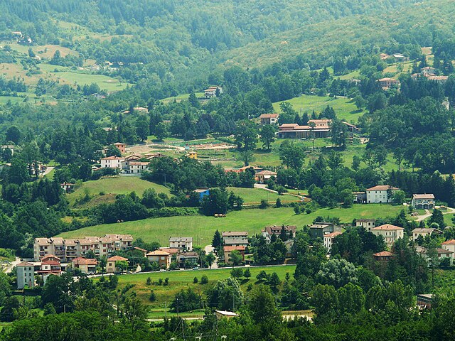
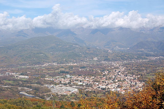
Понтремоли (Pontremoli, Pontremoli)
.svg)
- коммуна Италии
 Hiking in Понтремоли
Pontremoli, a charming town in the Lunigiana region of Tuscany, Italy, offers a variety of hiking opportunities for outdoor enthusiasts. Nestled in the Apennine Mountains, it is surrounded by stunning natural landscapes, rich history, and vibrant culture. Here are some key points to consider for hiking in and around Pontremoli:
Trails and Routes
-
Sentiero dei Fidanzati: This picturesque trail connects Pontremoli with the surrounding villages. It offers beautiful views of the Lunigiana valley, dense forests, and historical sites.
-
Montalto Peak: A more challenging hike leads you to Montalto, the highest peak in the area. The trail can be steep in parts, but the panoramic views from the top are worth the effort.
-
Montemarcello-Magra Regional Park: A short drive from Pontremoli, this park offers various trails that explore beautiful coastal areas and inland hills.
-
Lunigiana Trails: The region boasts a network of trails that connect old castles, medieval villages, and natural reserves. Many of these routes are well-marked and suitable for varying levels of experience.
Hiking Season
The best time for hiking in Pontremoli is typically from late spring (May) to early autumn (September), when the weather is mild and the trails are accessible. Summer can be hot, but mornings and evenings are usually pleasant for outdoor activities.
Preparation
- Footwear: Good hiking boots are essential due to the varied terrain.
- Navigation: A map or a hiking app can be helpful, although many trails are well-marked.
- Weather: Always check the weather forecast before heading out, as conditions can change quickly in the mountains.
Local Culture
While hiking, take the time to explore Pontremoli’s historical sites, such as the Romanesque churches and the ancient stone bridges. The town is known for its traditional cuisine, so be sure to try local dishes after a day on the trails!
Safety Tips
- Always inform someone of your hiking plans, especially if you're venturing into less populated areas.
- Carry enough water and snacks for your hike, and consider bringing a first aid kit.
- Wildlife is present, so be aware of your surroundings and follow local guidelines.
Hiking in Pontremoli can be a rewarding experience that combines physical activity with cultural exploration in a beautiful setting!
- Страна:

- Почтовый код: 54027
- Телефонный код: 0187
- Код автомобильного номера: MS
- Координаты: 44° 22' 34" N, 9° 52' 48" E


- GPS треки (wikiloc): [Ссылка]
- Высота над уровнем моря: 236 м m
- Площадь: 182.48 кв.км
- Население: 7193
- Веб сайт: http://www.comune.pontremoli.ms.it/
- Википедия русская: wiki(ru)
- Википедия английская: wiki(en)
- Википедия национальная: wiki(it)
- Хранилище Wikidata: Wikidata: Q52240
- Галерея изображений в википедии: [Ссылка]
- Катеория в википедии: [Ссылка]
- код Freebase: [/m/0bgdjf]
- код GeoNames: Альт: [6541078]
- код VIAF: Альт: [139614614]
- ID отношения в OpenStreetMap: [43060]
- UN/LOCODE: [ITPML]
- код ISTAT: 045014
- кадастровый код Италии: G870
Граничит с регионами:

Альбарето
- коммуна Италии
Hiking in Альбарето
Albareto is a charming village located in the province of Parma in the Emilia-Romagna region of northern Italy. It's surrounded by beautiful landscapes, making it a great destination for hiking enthusiasts. The area is characterized by rolling hills, dense forests, and panoramic views, offering various trails suitable for different skill levels....
- Страна:
- Почтовый код: 43051
- Телефонный код: 0525
- Код автомобильного номера: PR
- Координаты: 44° 26' 49" N, 9° 42' 8" E
- GPS треки (wikiloc): [Ссылка]
- Высота над уровнем моря: 512 м m
- Площадь: 104.11 кв.км
- Население: 2160
- Веб сайт: [Ссылка]


Берчето
- коммуна Италии
Hiking in Берчето
Berceto, a charming town located in the Emilia-Romagna region of northern Italy, is surrounded by beautiful landscapes and offers numerous hiking opportunities. Nestled in the Apennine Mountains, the area features lush forests, scenic views, and rich biodiversity, making it an excellent destination for outdoor enthusiasts....
- Страна:
- Почтовый код: 43042
- Телефонный код: 0525
- Код автомобильного номера: PR
- Координаты: 44° 30' 32" N, 9° 59' 28" E
- GPS треки (wikiloc): [Ссылка]
- Высота над уровнем моря: 852 м m
- Площадь: 131.71 кв.км
- Население: 2022
- Веб сайт: [Ссылка]


Борго-Валь-ди-Таро
- коммуна Италии
Hiking in Борго-Валь-ди-Таро
Borgo Val di Taro, located in the Emilia-Romagna region of Italy, is known for its stunning natural landscapes, rich historical heritage, and a variety of outdoor activities, including hiking. Here are some key points about hiking in this beautiful area:...
- Страна:
- Почтовый код: 43043
- Телефонный код: 0525
- Код автомобильного номера: PR
- Координаты: 44° 29' 0" N, 9° 46' 0" E
- GPS треки (wikiloc): [Ссылка]
- Высота над уровнем моря: 411 м m
- Площадь: 151.49 кв.км
- Население: 6907
- Веб сайт: [Ссылка]


Корнильо
- коммуна Италии
Hiking in Корнильо
Corniglio is a small town located in the Emilia-Romagna region of Italy, and it is surrounded by beautiful natural landscapes that make it a great destination for hiking enthusiasts. Here are some key points to consider when exploring hiking opportunities in and around Corniglio:...
- Страна:
- Почтовый код: 43021
- Телефонный код: 0521
- Код автомобильного номера: PR
- Координаты: 44° 29' 0" N, 10° 5' 0" E
- GPS треки (wikiloc): [Ссылка]
- Высота над уровнем моря: 690 м m
- Площадь: 165.7 кв.км
- Население: 1863
- Веб сайт: [Ссылка]

Филаттьера
- коммуна Италии
Hiking in Филаттьера
Filattiera is a charming village located in the province of Massa-Carrara, in the Tuscany region of Italy. Nestled in the Apuan Alps, it offers a variety of hiking opportunities that cater to different skill levels, along with stunning natural scenery and cultural sites....
- Страна:
- Почтовый код: 54023
- Телефонный код: 0187
- Код автомобильного номера: MS
- Координаты: 44° 20' 0" N, 9° 56' 0" E
- GPS треки (wikiloc): [Ссылка]
- Высота над уровнем моря: 213 м m
- Площадь: 48.78 кв.км
- Население: 2285
- Веб сайт: [Ссылка]


Мулаццо
- коммуна Италии
Hiking in Мулаццо
Mulazzo is a charming village located in the province of Massa-Carrara in Tuscany, Italy. It is situated in the Apuan Alps, which offers stunning landscapes and a variety of hiking opportunities. Here’s an overview of what you might expect when hiking in this beautiful area:...
- Страна:
- Почтовый код: 54026
- Телефонный код: 0187
- Код автомобильного номера: MS
- Координаты: 44° 19' 1" N, 9° 53' 26" E
- GPS треки (wikiloc): [Ссылка]
- Высота над уровнем моря: 351 м m
- Площадь: 62.51 кв.км
- Население: 2425
- Веб сайт: [Ссылка]

Виллафранка-ин-Луниджана
- коммуна Италии
Hiking in Виллафранка-ин-Луниджана
Villafranca in Lunigiana is a charming town located in the northern part of Tuscany, Italy, nestled in the beautiful Lunigiana region, which is characterized by its stunning natural landscapes, rich history, and medieval architecture. The area offers a variety of hiking opportunities for all levels of outdoor enthusiasts....
- Страна:
- Почтовый код: 54028
- Телефонный код: 0187
- Код автомобильного номера: MS
- Координаты: 44° 17' 44" N, 9° 57' 0" E
- GPS треки (wikiloc): [Ссылка]
- Высота над уровнем моря: 138 м m
- Площадь: 29.32 кв.км
- Население: 4727
- Веб сайт: [Ссылка]


Цери
- коммуна Италии
Hiking in Цери
Zeri is a beautiful area located in the Tuscany region of Italy, known for its stunning landscapes, rich biodiversity, and serene environment. It lies in the province of Massa-Carrara and is a great destination for hikers seeking both natural beauty and cultural experiences....
- Страна:
- Почтовый код: 54029
- Телефонный код: 0187
- Код автомобильного номера: MS
- Координаты: 44° 21' 0" N, 9° 46' 0" E
- GPS треки (wikiloc): [Ссылка]
- Высота над уровнем моря: 708 м m
- Площадь: 73.66 кв.км
- Население: 1057
- Веб сайт: [Ссылка]