
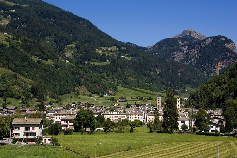
Понтрезина (Pontresina, Pontresina)

 Hiking in Понтрезина
Pontresina is a picturesque mountain village located in the Engadin valley of Switzerland, known for its stunning landscapes, diverse hiking trails, and proximity to the Bernina Range. Here are some key points about hiking in Pontresina:
Trails and Routes
-
Variety of Difficulty Levels: Pontresina offers hiking trails suitable for all skill levels, from easy walks to more challenging hikes. This makes it an ideal destination for families, casual hikers, and experienced trekkers alike.
-
Scenic Views: Many trails provide breathtaking views of the surrounding mountains, glaciers, and valleys. Popular routes include the paths around the Roseg Glacier and up to the Piz Bernina, the highest peak in the Bernina Range.
-
Silvretta Range: The region includes several marked trails leading to and from the nearby Silvretta Range, where you can experience a mix of alpine landscapes, lush meadows, and crystal-clear lakes.
-
Wildlife Observation: The area is rich in biodiversity, making it a prime spot for wildlife enthusiasts. Keep an eye out for ibex, marmots, and a variety of bird species.
Recommended Hikes
-
Roseg Glacier Trail: A moderate trail leading from Pontresina to the stunning Roseg Glacier, often taking around 2.5 to 3 hours one way. This hike features lush meadows and incredible glacier views.
-
Muottas Muragl: This mountain offers a range of hiking options. You can take a funicular from Pontresina to the top and choose various easy to moderate hiking paths with extraordinary views of the Engadin Lake District.
-
Lej da Staz: A beautiful circular trail around the pristine Lej da Staz lake, perfect for a leisurely hike. It's a relatively easy path with picnic spots along the way.
Practical Considerations
-
Weather: The weather in the Alps can change rapidly, so it’s essential to check the forecast and prepare for varying conditions. Layer your clothing and bring rain gear.
-
Safety: Familiarize yourself with the trail markings and obtain a map of the area if you plan to explore extensively. Consider hiking with a partner and inform someone of your planned route, especially for longer hikes.
-
Local Guides: If you're unfamiliar with the area or wish to enhance your experience, consider hiring a local hiking guide. They can provide invaluable knowledge about the region's flora, fauna, and history.
Accessibility
Pontresina is well-connected by public transport, making it easy to reach from neighboring towns and cities. The local tourist office can provide information on transportation and hiking opportunities.
Hiking in Pontresina offers a wonderful way to experience the natural beauty and tranquility of the Swiss Alps, making it a must-visit destination for outdoor enthusiasts. Enjoy your hike!
- Страна:

- Почтовый код: 7504
- Телефонный код: 081
- Код автомобильного номера: GR
- Координаты: 46° 26' 28" N, 9° 57' 27" E


- GPS треки (wikiloc): [Ссылка]
- Высота над уровнем моря: 2446 м m
- Площадь: 118.19 кв.км
- Население: 2195
- Веб сайт: http://www.gemeinde-pontresina.ch
- Википедия русская: wiki(ru)
- Википедия английская: wiki(en)
- Википедия национальная: wiki(de)
- Хранилище Wikidata: Wikidata: Q69259
- Катеория в википедии: [Ссылка]
- код Freebase: [/m/09_cg9]
- код GeoNames: Альт: [7286818]
- код VIAF: Альт: [168591287]
- ID отношения в OpenStreetMap: [1684131]
- код GND: Альт: [4046768-5]
- идентификатор местоположения ArchINFORM: [16581]
- код LCNAF: Альт: [n83052716]
- идентификатор HDS: [1540]
- код швейцарского муниципалитета: [3784]
Граничит с регионами:
Ланцада
- коммуна Италии
Hiking in Ланцада
Lanzada, located on the beautiful Galician coast in Spain, is known for its stunning beaches, picturesque landscapes, and vibrant natural surroundings, making it a great destination for hiking enthusiasts. Here’s an overview of what to expect when hiking in the Lanzada area:...
- Страна:

- Почтовый код: 23020
- Телефонный код: 0342
- Код автомобильного номера: SO
- Координаты: 46° 16' 0" N, 9° 52' 0" E
- GPS треки (wikiloc): [Ссылка]
- Высота над уровнем моря: 1000 м m
- Площадь: 117.17 кв.км
- Население: 1335
- Веб сайт: [Ссылка]


Ливиньо
- коммуна Италии
Hiking in Ливиньо
Livigno, located in the Italian Alps near the Swiss border, is a fantastic destination for hiking enthusiasts. This charming alpine resort is surrounded by stunning scenery, with lush valleys, high peaks, and pristine landscapes....
- Страна:
- Почтовый код: 23030
- Телефонный код: 0342
- Код автомобильного номера: SO
- Координаты: 46° 32' 0" N, 10° 8' 0" E
- GPS треки (wikiloc): [Ссылка]
- Высота над уровнем моря: 1816 м m
- Площадь: 227.3 кв.км
- Население: 6550
- Веб сайт: [Ссылка]


Челерина
Hiking in Челерина
Celerina-Schlarigna is a charming area located in the Engadin Valley in Switzerland, renowned for its breathtaking landscapes and outdoor recreational opportunities, particularly hiking. Here’s a comprehensive overview of hiking in this beautiful destination:...
- Страна:
- Почтовый код: 7505
- Телефонный код: 081
- Код автомобильного номера: GR
- Координаты: 46° 30' 34" N, 9° 50' 38" E
- GPS треки (wikiloc): [Ссылка]
- Высота над уровнем моря: 2007 м m
- Площадь: 24.02 кв.км
- Население: 1506
- Веб сайт: [Ссылка]


Ла-Пунт-Чамуэшч
Hiking in Ла-Пунт-Чамуэшч
La Punt-Chamues-ch is a picturesque village located in the Engadin valley of Switzerland, known for its stunning landscapes, traditional architecture, and excellent hiking opportunities. Here are some key aspects to consider when hiking in this beautiful region:...
- Страна:
- Почтовый код: 7522
- Телефонный код: 081
- Код автомобильного номера: GR
- Координаты: 46° 33' 59" N, 9° 54' 59" E
- GPS треки (wikiloc): [Ссылка]
- Высота над уровнем моря: 1687 м m
- Площадь: 63.27 кв.км
- Население: 712
- Веб сайт: [Ссылка]


Цуоц
Hiking in Цуоц
Zuoz, a charming village in the Engadin Valley of Switzerland, offers stunning landscapes and a variety of hiking options for all skill levels. The area is renowned for its natural beauty, with majestic mountains, lush forests, and scenic meadows....
- Страна:
- Почтовый код: 7524
- Телефонный код: 081
- Код автомобильного номера: GR
- Координаты: 46° 36' 7" N, 9° 57' 35" E
- GPS треки (wikiloc): [Ссылка]
- Высота над уровнем моря: 1718 м m
- Площадь: 65.79 кв.км
- Население: 1207
- Веб сайт: [Ссылка]


Мадулайн
Hiking in Мадулайн
Madulain is a picturesque village located in the Engadine Valley of Switzerland, known for its stunning landscapes and opportunities for hiking. Nestled at an altitude of about 1,400 meters (4,600 feet), it serves as an excellent base for exploring the surrounding natural beauty. Here are some highlights related to hiking in and around Madulain:...
- Страна:
- Почтовый код: 7523
- Телефонный код: 081
- Код автомобильного номера: GR
- Координаты: 46° 32' 46" N, 9° 57' 57" E
- GPS треки (wikiloc): [Ссылка]
- Высота над уровнем моря: 2270 м m
- Площадь: 16.28 кв.км
- Население: 209
- Веб сайт: [Ссылка]


Самедан
Hiking in Самедан
Samedan, located in the Engadin Valley of Switzerland, is a beautiful destination for hiking enthusiasts. The region offers a mix of stunning landscapes, picturesque villages, and a range of trails suited for different skill levels. Here are some highlights of hiking in Samedan:...
- Страна:
- Почтовый код: 7503
- Телефонный код: 081
- Код автомобильного номера: GR
- Координаты: 46° 32' 1" N, 9° 52' 19" E
- GPS треки (wikiloc): [Ссылка]
- Высота над уровнем моря: 2970 м m
- Площадь: 113.80 кв.км
- Население: 2956
- Веб сайт: [Ссылка]
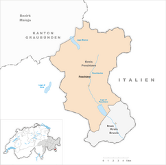
Поскьяво
Hiking in Поскьяво
Poschiavo is a picturesque valley located in the eastern part of Switzerland, with stunning landscapes that make it an excellent destination for hiking enthusiasts. The valley is part of the canton of Graubünden and is known for its blend of Swiss and Italian cultures, reflected in its charming villages and local cuisine....
- Страна:
- Почтовый код: 7742; 7746; 7741; 7710; 7745
- Телефонный код: 081
- Код автомобильного номера: GR
- Координаты: 46° 20' 0" N, 10° 2' 59" E
- GPS треки (wikiloc): [Ссылка]
- Высота над уровнем моря: 1014 м m
- Площадь: 191.01 кв.км
- Население: 3516
- Веб сайт: [Ссылка]