Ла-Пунт-Чамуэшч (La Punt-Chamues-ch, La Punt-Chamues-ch)

 Hiking in Ла-Пунт-Чамуэшч
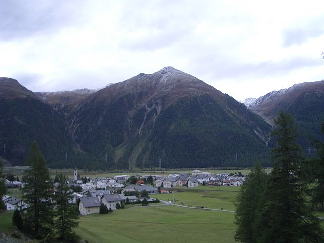
La Punt-Chamues-ch is a picturesque village located in the Engadin valley of Switzerland, known for its stunning landscapes, traditional architecture, and excellent hiking opportunities. Here are some key aspects to consider when hiking in this beautiful region:
1.
The area around La Punt-Chamues-ch offers a variety of hiking trails that cater to different skill levels, from easy walks suitable for families to challenging hikes for experienced trekkers. The trails often provide breathtaking views of the surrounding mountains, valleys, and the nearby lakes.
2.
- Trail to Lake Sils: This moderate hike offers stunning views of Lake Sils and the surrounding peaks. It's a great option for a day hike.
- Vicosoprano to La Punt: This enchanting trail follows the Via Engiadina, leading through picturesque villages and lush greenery.
- Piz Mezdi: For those looking for a challenge, this ascent rewards hikers with panoramic views of the entire Engadin region.
3.
- Spring/Summer: From late spring to early autumn, the trails are generally accessible, and wildflowers bloom, adding vibrant colors to the landscape.
- Autumn: This season provides a spectacular display of fall foliage, making hikes particularly scenic.
- Winter Sports: While traditional hiking may be limited in winter, the area is also popular for snowshoeing and winter hiking.
4.
La Punt-Chamues-ch has various amenities, including accommodation options, restaurants, and local shops. After a day of hiking, you can relax and enjoy traditional Swiss cuisine at one of the local restaurants.
5.
The Engadin region is rich in biodiversity. Keep an eye out for various flora and fauna, including ibex, marmots, and numerous bird species. The pristine environment makes it a paradise for nature lovers.
6.
La Punt-Chamues-ch is accessible via public transport, with regular train and bus services connecting it to other towns in the region, including St. Moritz and Zernez.
7.
Always check the weather forecast before heading out and ensure you have adequate gear, including sturdy hiking boots, weather-appropriate clothing, a map, and sufficient water and snacks. It's also advisable to inform someone of your hiking plans, especially if heading out on less-trafficked trails.
By planning accordingly and respecting the natural environment, you can enjoy an enriching hiking experience in La Punt-Chamues-ch!
- Страна:

- Почтовый код: 7522
- Телефонный код: 081
- Код автомобильного номера: GR
- Координаты: 46° 33' 59" N, 9° 54' 59" E


- GPS треки (wikiloc): [Ссылка]
- Высота над уровнем моря: 1687 м m
- Площадь: 63.27 кв.км
- Население: 712
- Веб сайт: http://www.lapunt.ch
- Википедия русская: wiki(ru)
- Википедия английская: wiki(en)
- Википедия национальная: wiki(de)
- Хранилище Wikidata: Wikidata: Q65637
- Катеория в википедии: [Ссылка]
- код Freebase: [/m/026dxzl]
- код GeoNames: Альт: [2659177]
- ID отношения в OpenStreetMap: [1684096]
- идентификатор HDS: [1541]
- код швейцарского муниципалитета: [3785]
Граничит с регионами:


Цуоц
Hiking in Цуоц
Zuoz, a charming village in the Engadin Valley of Switzerland, offers stunning landscapes and a variety of hiking options for all skill levels. The area is renowned for its natural beauty, with majestic mountains, lush forests, and scenic meadows....
- Страна:
- Почтовый код: 7524
- Телефонный код: 081
- Код автомобильного номера: GR
- Координаты: 46° 36' 7" N, 9° 57' 35" E
- GPS треки (wikiloc): [Ссылка]
- Высота над уровнем моря: 1718 м m
- Площадь: 65.79 кв.км
- Население: 1207
- Веб сайт: [Ссылка]


Мадулайн
Hiking in Мадулайн
Madulain is a picturesque village located in the Engadine Valley of Switzerland, known for its stunning landscapes and opportunities for hiking. Nestled at an altitude of about 1,400 meters (4,600 feet), it serves as an excellent base for exploring the surrounding natural beauty. Here are some highlights related to hiking in and around Madulain:...
- Страна:
- Почтовый код: 7523
- Телефонный код: 081
- Код автомобильного номера: GR
- Координаты: 46° 32' 46" N, 9° 57' 57" E
- GPS треки (wikiloc): [Ссылка]
- Высота над уровнем моря: 2270 м m
- Площадь: 16.28 кв.км
- Население: 209
- Веб сайт: [Ссылка]


Бергюн
Hiking in Бергюн
Bergün, located in the scenic Albula Valley in the Swiss canton of Graubünden, is a fantastic destination for hiking enthusiasts. The area offers a variety of trails that cater to different skill levels, making it suitable for families, casual hikers, and experienced trekkers alike. Here are some highlights of hiking in Bergün:...
- Страна:
- Почтовый код: 7482
- Телефонный код: 081
- Код автомобильного номера: GR
- Координаты: 46° 37' 26" N, 9° 47' 14" E
- GPS треки (wikiloc): [Ссылка]
- Высота над уровнем моря: 1367 м m
- Площадь: 145.65 кв.км
- Население: 480
- Веб сайт: [Ссылка]


Самедан
Hiking in Самедан
Samedan, located in the Engadin Valley of Switzerland, is a beautiful destination for hiking enthusiasts. The region offers a mix of stunning landscapes, picturesque villages, and a range of trails suited for different skill levels. Here are some highlights of hiking in Samedan:...
- Страна:
- Почтовый код: 7503
- Телефонный код: 081
- Код автомобильного номера: GR
- Координаты: 46° 32' 1" N, 9° 52' 19" E
- GPS треки (wikiloc): [Ссылка]
- Высота над уровнем моря: 2970 м m
- Площадь: 113.80 кв.км
- Население: 2956
- Веб сайт: [Ссылка]

Бевер
- коммуна
Hiking in Бевер
Bever, Switzerland, is a charming village located in the Engadin Valley and is part of the UNESCO Biosphere Reserve. It offers incredible hiking opportunities amidst stunning alpine scenery, making it an attractive destination for both novice and seasoned hikers. Here are some key details about hiking in Bever:...
- Страна:
- Почтовый код: 7502
- Телефонный код: 081
- Код автомобильного номера: GR
- Координаты: 46° 32' 59" N, 9° 52' 59" E
- GPS треки (wikiloc): [Ссылка]
- Высота над уровнем моря: 2653 м m
- Площадь: 47.75 кв.км
- Население: 598
- Веб сайт: [Ссылка]


Понтрезина
Hiking in Понтрезина
Pontresina is a picturesque mountain village located in the Engadin valley of Switzerland, known for its stunning landscapes, diverse hiking trails, and proximity to the Bernina Range. Here are some key points about hiking in Pontresina:...
- Страна:
- Почтовый код: 7504
- Телефонный код: 081
- Код автомобильного номера: GR
- Координаты: 46° 26' 28" N, 9° 57' 27" E
- GPS треки (wikiloc): [Ссылка]
- Высота над уровнем моря: 2446 м m
- Площадь: 118.19 кв.км
- Население: 2195
- Веб сайт: [Ссылка]