Оберенгадин (Oberengadin, Kreis Oberengadin)
- подокруг кантона Граубюнден
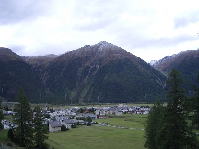
 Hiking in Оберенгадин
Kreis Oberengadin, located in the Swiss canton of Graubünden, is a stunning region known for its breathtaking landscapes, pristine nature, and extensive hiking trails. Here’s what you can expect when hiking in this beautiful area:
Scenic Trails
-
Variety of Trails: Oberengadin offers a wide range of hiking trails suitable for all levels, from easy walks to challenging mountain hikes. The paths often lead through picturesque valleys, along crystal-clear lakes, and up into the high peaks of the Swiss Alps.
-
Popular Hikes:
- Lake Sils to Lake Silvaplana: This relatively easy trail takes you through meadows and offers fantastic views of the lakes and surrounding mountains.
- Muottas Muragl: A hike that can be started from the mountain railway station, leading to viewpoints that offer panoramic vistas of the Engadin Valley and the Bernina range.
- Corvatsch: More challenging routes around the Corvatsch mountain provide the opportunity to explore higher altitudes and enjoy dramatic alpine scenery.
-
Alpine Flora and Fauna: The region is rich in biodiversity. Hikers can encounter various wildlife and protected plant species along the trails. Exploring these paths during different seasons reveals unique wildflowers in the summer and striking autumn colors.
Stunning Views
The Oberengadin region is characterized by its dramatic mountain scenery, including the Piz Bernina and the Engadin Valley. Scenic overlooks offer fantastic photographic opportunities, especially at sunrise and sunset.
Additional Tips
-
Weather Considerations: The weather can change rapidly in the mountains, so it's crucial to check conditions before setting out. Dress in layers and be prepared for sudden changes.
-
Trail Markings: Hiking paths are well-marked with the Swiss hiking symbol (white-red-white). It’s a good idea to have a local map or GPS device to help navigate less obvious paths.
-
Local Culture: Take the time to enjoy the traditional Engadin culture, including its architecture, cuisine, and hospitality. Stopping at mountain huts can provide a taste of local specialties.
-
Safety: Always inform someone about your hiking plans, especially if you're heading into remote areas. Ensure you have enough water, snacks, and a first-aid kit, and consider the altitude when planning your hikes.
Accessibility
Kreis Oberengadin is well-connected by public transport, and many hiking trailheads are reachable via train and bus. The region is also bike-friendly, allowing for an alternative way to explore the stunning landscape.
In summary, hiking in Kreis Oberengadin is an unforgettable experience that showcases the natural beauty of the Swiss Alps. Plan your route depending on your skill level, and take the time to immerse yourself in the serene environment and local culture.
- Страна:

- Хранилище Wikidata: Wikidata: Q688449
Включает регионы:


Зильс-им-Энгадин
Hiking in Зильс-им-Энгадин
Sils im Engadin-Segli is a picturesque village located in the Engadine Valley of Switzerland, renowned for its stunning landscapes and excellent hiking opportunities. This area is part of the larger UNESCO World Heritage site of the Swiss Alps and offers a range of trails suitable for different skill levels....
- Страна:
- Почтовый код: 7514
- Телефонный код: 081
- Код автомобильного номера: GR
- Координаты: 46° 25' 59" N, 9° 45' 59" E


- GPS треки (wikiloc): [Ссылка]
- Высота над уровнем моря: 1803 м m
- Площадь: 63.57 кв.км
- Население: 691
- Веб сайт: [Ссылка]


Челерина
Hiking in Челерина
Celerina-Schlarigna is a charming area located in the Engadin Valley in Switzerland, renowned for its breathtaking landscapes and outdoor recreational opportunities, particularly hiking. Here’s a comprehensive overview of hiking in this beautiful destination:...
- Страна:
- Почтовый код: 7505
- Телефонный код: 081
- Код автомобильного номера: GR
- Координаты: 46° 30' 34" N, 9° 50' 38" E
- GPS треки (wikiloc): [Ссылка]
- Высота над уровнем моря: 2007 м m
- Площадь: 24.02 кв.км
- Население: 1506
- Веб сайт: [Ссылка]


Сильваплана
Hiking in Сильваплана
Silvaplana, located in the Engadin valley in Switzerland, is a beautiful destination for hiking enthusiasts. Nestled between the stunning lakes of Silvaplana and Sils, and surrounded by imposing mountain scenery, it offers a variety of hiking trails for all levels of experience....
- Страна:
- Почтовый код: 7513
- Телефонный код: 081
- Код автомобильного номера: GR
- Координаты: 46° 27' 29" N, 9° 47' 43" E
- GPS треки (wikiloc): [Ссылка]
- Высота над уровнем моря: 1817 м m
- Площадь: 44.77 кв.км
- Население: 1117
- Веб сайт: [Ссылка]


Шчанф
Hiking in Шчанф
S-chanf, a picturesque village located in the Engadin Valley of Switzerland, offers a variety of hiking opportunities for outdoor enthusiasts of all skill levels. Here are some aspects to consider when hiking in this beautiful area:...
- Страна:
- Почтовый код: 7525
- Телефонный код: 081
- Код автомобильного номера: GR
- Координаты: 46° 36' 59" N, 9° 59' 0" E
- GPS треки (wikiloc): [Ссылка]
- Высота над уровнем моря: 1878 м m
- Площадь: 138.03 кв.км
- Население: 685
- Веб сайт: [Ссылка]


Ла-Пунт-Чамуэшч
Hiking in Ла-Пунт-Чамуэшч
La Punt-Chamues-ch is a picturesque village located in the Engadin valley of Switzerland, known for its stunning landscapes, traditional architecture, and excellent hiking opportunities. Here are some key aspects to consider when hiking in this beautiful region:...
- Страна:
- Почтовый код: 7522
- Телефонный код: 081
- Код автомобильного номера: GR
- Координаты: 46° 33' 59" N, 9° 54' 59" E
- GPS треки (wikiloc): [Ссылка]
- Высота над уровнем моря: 1687 м m
- Площадь: 63.27 кв.км
- Население: 712
- Веб сайт: [Ссылка]


Цуоц
Hiking in Цуоц
Zuoz, a charming village in the Engadin Valley of Switzerland, offers stunning landscapes and a variety of hiking options for all skill levels. The area is renowned for its natural beauty, with majestic mountains, lush forests, and scenic meadows....
- Страна:
- Почтовый код: 7524
- Телефонный код: 081
- Код автомобильного номера: GR
- Координаты: 46° 36' 7" N, 9° 57' 35" E
- GPS треки (wikiloc): [Ссылка]
- Высота над уровнем моря: 1718 м m
- Площадь: 65.79 кв.км
- Население: 1207
- Веб сайт: [Ссылка]


Мадулайн
Hiking in Мадулайн
Madulain is a picturesque village located in the Engadine Valley of Switzerland, known for its stunning landscapes and opportunities for hiking. Nestled at an altitude of about 1,400 meters (4,600 feet), it serves as an excellent base for exploring the surrounding natural beauty. Here are some highlights related to hiking in and around Madulain:...
- Страна:
- Почтовый код: 7523
- Телефонный код: 081
- Код автомобильного номера: GR
- Координаты: 46° 32' 46" N, 9° 57' 57" E
- GPS треки (wikiloc): [Ссылка]
- Высота над уровнем моря: 2270 м m
- Площадь: 16.28 кв.км
- Население: 209
- Веб сайт: [Ссылка]


Санкт-Мориц
Hiking in Санкт-Мориц
St. Moritz, located in the Swiss Alps, is renowned for its stunning landscapes and offers incredible hiking opportunities for both novice and experienced hikers. The region is characterized by its picturesque lakes, majestic mountains, and lush valleys, making it an ideal destination for outdoor enthusiasts. Here are some highlights and tips for hiking in St. Moritz:...
- Страна:
- Почтовый код: 7500
- Телефонный код: 081
- Код автомобильного номера: GR
- Координаты: 46° 29' 51" N, 9° 50' 17" E
- GPS треки (wikiloc): [Ссылка]
- Высота над уровнем моря: 1822 м m
- Площадь: 28.69 кв.км
- Население: 4994
- Веб сайт: [Ссылка]


Самедан
Hiking in Самедан
Samedan, located in the Engadin Valley of Switzerland, is a beautiful destination for hiking enthusiasts. The region offers a mix of stunning landscapes, picturesque villages, and a range of trails suited for different skill levels. Here are some highlights of hiking in Samedan:...
- Страна:
- Почтовый код: 7503
- Телефонный код: 081
- Код автомобильного номера: GR
- Координаты: 46° 32' 1" N, 9° 52' 19" E
- GPS треки (wikiloc): [Ссылка]
- Высота над уровнем моря: 2970 м m
- Площадь: 113.80 кв.км
- Население: 2956
- Веб сайт: [Ссылка]

Бевер
- коммуна
Hiking in Бевер
Bever, Switzerland, is a charming village located in the Engadin Valley and is part of the UNESCO Biosphere Reserve. It offers incredible hiking opportunities amidst stunning alpine scenery, making it an attractive destination for both novice and seasoned hikers. Here are some key details about hiking in Bever:...
- Страна:
- Почтовый код: 7502
- Телефонный код: 081
- Код автомобильного номера: GR
- Координаты: 46° 32' 59" N, 9° 52' 59" E
- GPS треки (wikiloc): [Ссылка]
- Высота над уровнем моря: 2653 м m
- Площадь: 47.75 кв.км
- Население: 598
- Веб сайт: [Ссылка]


Понтрезина
Hiking in Понтрезина
Pontresina is a picturesque mountain village located in the Engadin valley of Switzerland, known for its stunning landscapes, diverse hiking trails, and proximity to the Bernina Range. Here are some key points about hiking in Pontresina:...
- Страна:
- Почтовый код: 7504
- Телефонный код: 081
- Код автомобильного номера: GR
- Координаты: 46° 26' 28" N, 9° 57' 27" E
- GPS треки (wikiloc): [Ссылка]
- Высота над уровнем моря: 2446 м m
- Площадь: 118.19 кв.км
- Население: 2195
- Веб сайт: [Ссылка]