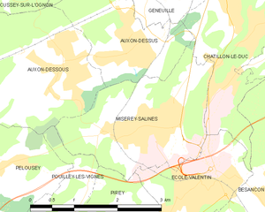
Pouilley-les-Vignes (Pouilley-les-Vignes)

- коммуна во Франции
 Hiking in Pouilley-les-Vignes
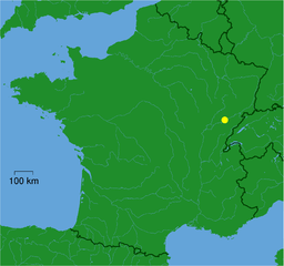
Pouilley-les-Vignes is a charming commune located in the Doubs department of France, nearby the city of Besançon. The area is known for its picturesque landscapes, which makes it a great spot for hiking enthusiasts.
Hiking Opportunities:
-
Scenic Trails: The region features several trails that wind through forests, fields, and vineyards. Depending on the season, you might encounter beautiful floral displays in spring or vibrant autumn colors.
-
Varied Terrain: The hiking trails in and around Pouilley-les-Vignes can vary in difficulty, catering to both beginners and experienced hikers. Whether you prefer gentle walks or more challenging hikes, there's likely a trail that fits your level.
-
Local Parks and Nature Reserves: Nearby nature parks or reserves may offer designated hiking paths, where hikers can enjoy the natural beauty and wildlife of the area.
-
Historical Sites: Some trails might lead you to historical landmarks or viewpoints where you can take in the surrounding countryside and learn about the local history.
Tips for Hiking in Pouilley-les-Vignes:
- Check Local Maps: Before heading out, make sure to check local hiking maps for trail conditions and difficulty levels.
- Dress Appropriately: Wear suitable hiking gear and footwear, as some trails can be uneven or muddy, and weather can change quickly.
- Stay Hydrated: Bring plenty of water, especially on warm days, and consider packing a small snack for energy.
- Respect Nature: Follow Leave No Trace principles to preserve the natural beauty of the area for future visitors.
Remember to check local regulations and trail status, especially if you're planning a hike during the shoulder seasons when conditions can be more variable. Enjoy your hiking adventure in Pouilley-les-Vignes!
- Страна:

- Почтовый код: 25115
- Координаты: 47° 15' 25" N, 5° 56' 9" E


- GPS треки (wikiloc): [Ссылка]
- Площадь: 9.34 кв.км
- Население: 1951
- Веб сайт: http://www.pouilleylesvignes.com
- Википедия английская: wiki(en)
- Википедия национальная: wiki(fr)
- Хранилище Wikidata: Wikidata: Q906642
- Катеория в википедии: [Ссылка]
- код Freebase: [/m/03mhc59]
- код Freebase: [/m/03mhc59]
- код GeoNames: Альт: [2985850]
- код GeoNames: Альт: [2985850]
- номер SIREN: [212504674]
- номер SIREN: [212504674]
- код BNF: [152526936]
- код BNF: [152526936]
- код муниципалитета INSEE: 25467
- код муниципалитета INSEE: 25467
Граничит с регионами:

Безансон
- коммуна во Франции
Hiking in Безансон
Besançon, located in the Franche-Comté region of eastern France, is an excellent destination for hiking enthusiasts. Surrounded by the picturesque Jura Mountains and the Doubs River, the area offers diverse landscapes, from rolling hills and dense forests to stunning viewpoints and historical sites....
- Страна:
- Почтовый код: 25000
- Координаты: 47° 14' 32" N, 6° 1' 17" E
- GPS треки (wikiloc): [Ссылка]
- Высота над уровнем моря: 281 м m
- Площадь: 65.05 кв.км
- Население: 116676
- Веб сайт: [Ссылка]

Miserey-Salines
- коммуна во Франции
Hiking in Miserey-Salines
Miserey-Salines is a quaint commune located in the Doubs department in the Bourgogne-Franche-Comté region of France. While it may not be one of the most frequently mentioned hiking destinations, it offers a serene and picturesque environment, ideal for those looking to escape the hustle and bustle of city life....
- Страна:
- Почтовый код: 25480
- Координаты: 47° 17' 11" N, 5° 58' 25" E
- GPS треки (wikiloc): [Ссылка]
- Площадь: 6.22 кв.км
- Население: 2383

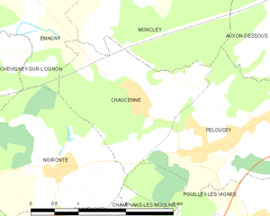
Chaucenne
- коммуна во Франции
Hiking in Chaucenne
Chaucenne is not widely recognized as a hiking destination, and there may be some confusion regarding its exact location or spelling. However, it’s possible that you meant a specific area or trail that has similar sounding names....
- Страна:
- Почтовый код: 25170
- Координаты: 47° 17' 5" N, 5° 53' 52" E
- GPS треки (wikiloc): [Ссылка]
- Площадь: 4.88 кв.км
- Население: 519
- Веб сайт: [Ссылка]


Champvans-les-Moulins
- коммуна во Франции
Hiking in Champvans-les-Moulins
Champvans-les-Moulins is a small village located in the Bourgogne-Franche-Comté region of France. While it's not widely known as a hiking destination, the surrounding area offers beautiful landscapes typical of the French countryside, with rolling hills, forests, and streams that can provide a tranquil setting for hiking enthusiasts....
- Страна:
- Почтовый код: 25170
- Координаты: 47° 15' 19" N, 5° 54' 56" E
- GPS треки (wikiloc): [Ссылка]
- Площадь: 2.52 кв.км
- Население: 352


Serre-les-Sapins
- коммуна во Франции
Hiking in Serre-les-Sapins
Serre-les-Sapins is located in the French Alps, known for its beautiful landscapes, diverse flora and fauna, and a range of hiking opportunities. Here are some aspects to consider when hiking in this area:...
- Страна:
- Почтовый код: 25770
- Координаты: 47° 14' 32" N, 5° 55' 45" E
- GPS треки (wikiloc): [Ссылка]
- Площадь: 5.24 кв.км
- Население: 1556


Pelousey
- коммуна во Франции
Hiking in Pelousey
It seems like there might be a typo or misunderstanding regarding "Pelousey." If you're referring to a location known for hiking, could you please specify the correct name? However, if you're interested in information about hiking in a general area or region, I can certainly help with that!...
- Страна:
- Почтовый код: 25170
- Координаты: 47° 16' 31" N, 5° 55' 18" E
- GPS треки (wikiloc): [Ссылка]
- Площадь: 6.18 кв.км
- Население: 1495
- Веб сайт: [Ссылка]

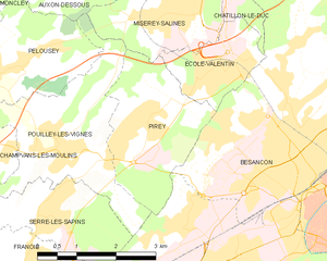
Pirey
- коммуна во Франции
Hiking in Pirey
Pirey, located near the city of Besançon in the Franche-Comté region of France, offers a variety of scenic hiking opportunities, especially for those interested in exploring the beautiful natural landscapes of the Jura Mountains....
- Страна:
- Почтовый код: 25480
- Координаты: 47° 15' 42" N, 5° 57' 47" E
- GPS треки (wikiloc): [Ссылка]
- Площадь: 6.67 кв.км
- Население: 2052
- Веб сайт: [Ссылка]


Noironte
- коммуна во Франции
Hiking in Noironte
Noironte is a lesser-known destination for hiking, and getting specific information might be challenging if you haven’t found particular trails or parks in mind. However, if it's located in a region known for outdoor activities, you can generally expect a few common features:...
- Страна:
- Почтовый код: 25170
- Координаты: 47° 16' 19" N, 5° 52' 28" E
- GPS треки (wikiloc): [Ссылка]
- Площадь: 6.73 кв.км
- Население: 380
- Веб сайт: [Ссылка]