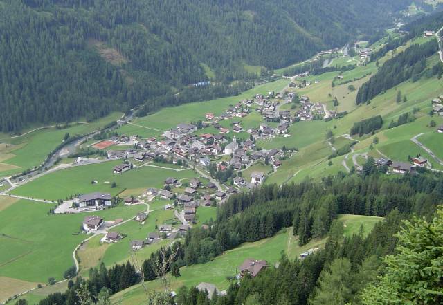
Предой (Prettau, Predoi)
.svg)
- коммуна в Италии
 Hiking in Предой
Prettau, located in the Ahrntal Valley of South Tyrol, Italy, is a fantastic destination for hiking enthusiasts. The area offers breathtaking landscapes, including majestic mountains, lush valleys, and crystal-clear streams. Here are some highlights for hiking in Prettau:
Scenic Trails
-
Runde Prettauer Höhenweg: This circular trail offers breathtaking panoramic views of the surrounding peaks and valleys. It’s suitable for hikers of varying skill levels and is particularly beautiful in the summer when wildflowers are in bloom.
-
Klausberg: The hiking trails around Klausberg are well-marked and provide options for both easy and challenging routes. You can enjoy the stunning scenery while taking in the fresh mountain air.
-
Zillertal Alps Nature Park: The nearby nature park features numerous trails, from gentle walks to more challenging ascents. The park is home to diverse flora and fauna, making it a perfect spot for nature lovers.
Family-Friendly Hikes
Prettau offers family-friendly trails that are suitable for children, such as the paths around the Klausberg area. Consider choosing shorter, easier routes that allow for plenty of breaks and exploration along the way.
Seasonal Considerations
- Summer: During the summer months, the trails are usually clear and accessible, with many huts open for refreshments. The weather can be warm, so it’s essential to stay hydrated and wear appropriate sun protection.
- Autumn: Fall brings stunning foliage and cooler temperatures, making for ideal hiking conditions.
Accessibility and Facilities
Prettau has good access to various trailheads, and local visitor centers can provide maps and information about trail conditions. There are also accommodation options ranging from hotels to guesthouses.
Tips for Hiking in Prettau
- Prepare Accordingly: The weather in the mountains can change quickly, so bring layers, a good hat, and waterproof gear.
- Stay Hydrated and Fueled: Always pack enough water and snacks, especially if you're planning longer hikes.
- Respect Nature: Follow the Leave No Trace principles to preserve the beauty of the environment.
Whether you're seeking challenging hikes or leisurely strolls, Prettau has something for everyone. Enjoy your time in this stunning region!
- Страна:

- Почтовый код: 39030
- Телефонный код: 0474
- Код автомобильного номера: BZ
- Координаты: 47° 2' 25" N, 12° 6' 24" E


- GPS треки (wikiloc): [Ссылка]
- Высота над уровнем моря: 1475 м m
- Площадь: 86.36 кв.км
- Население: 547
- Веб сайт: http://www.gemeinde.prettau.bz.it
- Википедия русская: wiki(ru)
- Википедия английская: wiki(en)
- Википедия национальная: wiki(it)
- Хранилище Wikidata: Wikidata: Q474195
- Галерея изображений в википедии: [Ссылка]
- Катеория в википедии: [Ссылка]
- код Freebase: [/m/0g9j1v]
- код GeoNames: Альт: [6535922]
- код VIAF: Альт: [235071090]
- ID отношения в OpenStreetMap: [47339]
- код GND: Альт: [4116100-2]
- код ISTAT: 021068
- кадастровый код Италии: H019
Граничит с регионами:


Кримль
Hiking in Кримль
Krimml, located in the Austrian state of Salzburg, is known for its stunning natural beauty, particularly the impressive Krimml Waterfalls, which are the highest waterfalls in Austria. Hiking in this area offers a variety of trails that cater to different skill levels, with opportunities to enjoy picturesque landscapes, alpine views, and the rich biodiversity of the Hohe Tauern National Park....
- Страна:

- Почтовый код: 5743
- Телефонный код: 06564
- Код автомобильного номера: ZE
- Координаты: 47° 13' 6" N, 12° 10' 24" E
- GPS треки (wikiloc): [Ссылка]
- Высота над уровнем моря: 1067 м m
- Площадь: 169.21 кв.км
- Население: 847
- Веб сайт: [Ссылка]
Санкт-Якоб-ин-Деферегген
Hiking in Санкт-Якоб-ин-Деферегген
St. Jakob in Defereggen, located in the Austrian Alps in the East Tyrol region, is a fantastic destination for hiking enthusiasts. The area is known for its stunning natural landscapes, diverse flora and fauna, and breathtaking mountain views. Here are some key highlights about hiking in this beautiful area:...
- Страна:
- Почтовый код: 9963
- Телефонный код: 04873
- Код автомобильного номера: LZ
- Координаты: 46° 56' 30" N, 12° 14' 48" E
- GPS треки (wikiloc): [Ссылка]
- Высота над уровнем моря: 2570 м m
- Площадь: 186 кв.км
- Население: 848
- Веб сайт: [Ссылка]
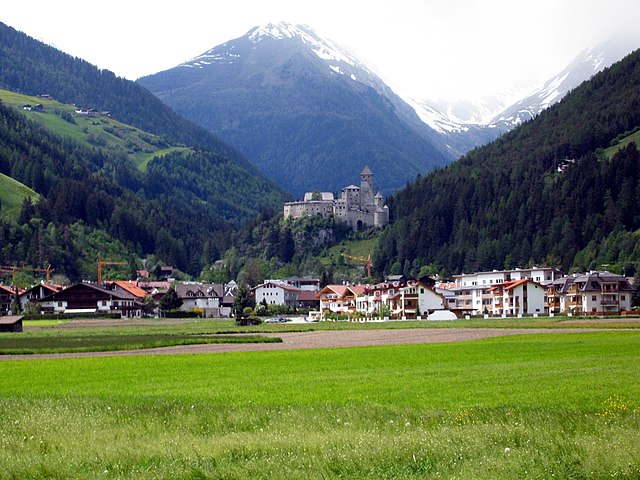

Кампо-Турес
- коммуна Италии
Hiking in Кампо-Турес
Sand in Taufers, or Campo Tures as it is known in Italian, is a picturesque village located in the Ahrntal Valley in South Tyrol, Italy. It's renowned for its stunning natural scenery, rich cultural heritage, and a variety of outdoor activities, particularly hiking. Here are some key points about hiking in this beautiful region:...
- Страна:
- Почтовый код: 39032
- Телефонный код: 0474
- Код автомобильного номера: BZ
- Координаты: 46° 54' 30" N, 11° 57' 37" E
- GPS треки (wikiloc): [Ссылка]
- Высота над уровнем моря: 864 м m
- Площадь: 163.98 кв.км
- Население: 5430
- Веб сайт: [Ссылка]
Валле-Аурина
- коммуна в Италии
Hiking in Валле-Аурина
Ahrntal, also known as the Aurina Valley, is a stunning destination for hiking enthusiasts located in the South Tyrol region of northern Italy. Nestled in the Zillertal Alps, this area is characterized by its breathtaking landscapes, towering peaks, lush meadows, and pristine valleys....
- Страна:
- Почтовый код: 39030
- Телефонный код: 0474
- Код автомобильного номера: BZ
- Координаты: 46° 59' 49" N, 11° 58' 49" E
- GPS треки (wikiloc): [Ссылка]
- Высота над уровнем моря: 1054 м m
- Площадь: 187.89 кв.км
- Население: 5991
- Веб сайт: [Ссылка]

Брандберг
Hiking in Брандберг
Brandberg, located in the Tyrolean region of Austria, is known for its stunning landscapes and diverse hiking opportunities. This area is nestled within the majestic Alps, offering hikers a mix of alpine meadows, rugged mountains, and picturesque valleys. Here's what you can expect when hiking in Brandberg:...
- Страна:
- Почтовый код: 6290
- Телефонный код: 05285
- Код автомобильного номера: SZ
- Координаты: 47° 10' 0" N, 11° 54' 0" E
- GPS треки (wikiloc): [Ссылка]
- Высота над уровнем моря: 1082 м m
- Площадь: 156.5 кв.км
- Население: 354
- Веб сайт: [Ссылка]


Прегратен-ам-Гросфенедигер
Hiking in Прегратен-ам-Гросфенедигер
Prägraten am Großvenediger is a beautiful village located in the Hohe Tauern National Park in Austria, renowned for its stunning alpine scenery and diverse hiking opportunities. Here's an overview of what you can expect when hiking in this area:...
- Страна:
- Почтовый код: 9974
- Телефонный код: 04877
- Код автомобильного номера: LZ
- Координаты: 47° 1' 0" N, 12° 22' 0" E
- GPS треки (wikiloc): [Ссылка]
- Высота над уровнем моря: 1312 м m
- Площадь: 180.36 кв.км
- Население: 1149
- Веб сайт: [Ссылка]