
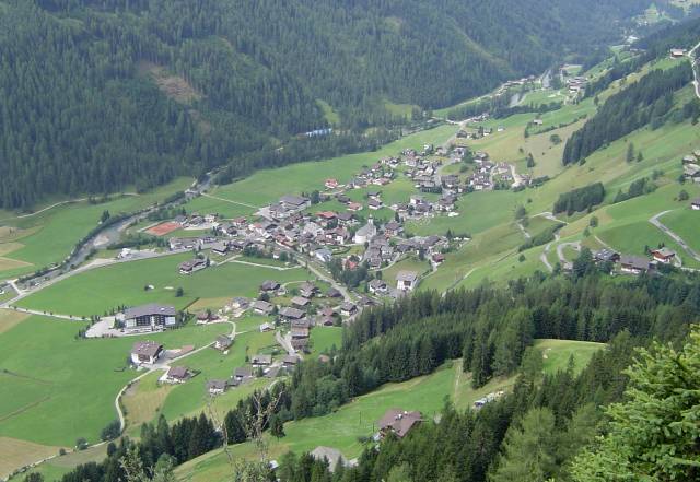
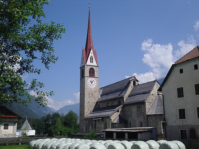
Кампо-Турес (Sand in Taufers, Campo Tures)
.svg)
- коммуна Италии
 Hiking in Кампо-Турес
Sand in Taufers, or Campo Tures as it is known in Italian, is a picturesque village located in the Ahrntal Valley in South Tyrol, Italy. It's renowned for its stunning natural scenery, rich cultural heritage, and a variety of outdoor activities, particularly hiking. Here are some key points about hiking in this beautiful region:
Hikes and Trails
-
Variety of Trails: Sand in Taufers offers a wide range of hiking trails suitable for all levels of experience, from leisurely walks to challenging mountain hikes. You can find well-marked paths that lead you through lush forests, along rivers, and up to scenic viewpoints.
-
The Ahrntal Valley: The surrounding Ahrntal Valley is home to numerous hiking routes. Popular trails include the paths leading to the Taurina Waterfall and the beautiful Lake Aurina, which are perfect for family hikes.
-
High-Altitude Treks: For experienced hikers, there are more demanding trails that take you into higher altitudes. The Ratschinger Höhenweg and trails in the nearby Zillertal Alps provide challenging routes with stunning panoramic views.
-
Cultural and Natural Highlights: Some hikes also allow you to explore cultural landmarks, such as the Taufers Castle, as well as various alpine flora and fauna.
Season and Conditions
-
Best Time to Hike: The hiking season typically runs from late spring to early autumn (May to October). During this time, the trails are usually clear of snow, and the weather is generally mild, though it’s wise to check local conditions before setting off, as weather can change rapidly in the mountains.
-
Preparation: Make sure to adhere to local weather advisories and be prepared for varying conditions. It's recommended to bring plenty of water, appropriate footwear, and sun protection.
Local Tips
-
Maps and Guides: Obtain updated hiking maps from local tourist information centers, as they can offer insights into trail conditions and points of interest.
-
Guided Tours: If you prefer a more structured experience, consider joining guided hiking tours, which can provide valuable knowledge about the local environment and culture.
-
Public Transport: The region is accessible by public transport, which can help you reach various trailheads without the need for a car.
Safety Considerations
-
Always inform someone of your hiking plans and expected return time, particularly if you are hiking in more remote areas.
-
Cell phone coverage may be limited in certain spots, so consider carrying a portable charger and a map.
Hiking in Sand in Taufers provides a wonderful way to engage with the stunning landscapes and rich culture of the South Tyrol region, making it a memorable experience for both beginners and seasoned hikers alike.
- Страна:

- Почтовый код: 39032
- Телефонный код: 0474
- Код автомобильного номера: BZ
- Координаты: 46° 54' 30" N, 11° 57' 37" E


- GPS треки (wikiloc): [Ссылка]
- Высота над уровнем моря: 864 м m
- Площадь: 163.98 кв.км
- Население: 5430
- Веб сайт: http://www.comune.campotures.bz.it
- Википедия русская: wiki(ru)
- Википедия английская: wiki(en)
- Википедия национальная: wiki(it)
- Хранилище Wikidata: Wikidata: Q376944
- Галерея изображений в википедии: [Ссылка]
- Катеория в википедии: [Ссылка]
- код Freebase: [/m/0g9g1p]
- код GeoNames: Альт: [6535889]
- код VIAF: Альт: [240087966]
- ID отношения в OpenStreetMap: [47335]
- код GND: Альт: [4562394-6]
- место в MusicBrainz: [274096d4-b66e-4206-b461-f65d8c1a843a]
- UN/LOCODE: [ITTUR]
- код в Итальянской энциклопедии онлайн: [campo-tures]
- код ISTAT: 021017
- кадастровый код Италии: B570
Граничит с регионами:


Разун-Антерсельва
- коммуна в Италии
Hiking in Разун-Антерсельва
Rasen-Antholz (Rasen-Antholz in German, or Rasun-Anterselva in Italian) is a picturesque valley located in the South Tyrol region of northern Italy, surrounded by the stunning Dolomites. This area is particularly popular for hiking due to its breathtaking landscapes, diverse trails, and natural beauty....
- Страна:
- Почтовый код: 39030
- Телефонный код: 0474
- Код автомобильного номера: BZ
- Координаты: 46° 51' 0" N, 12° 6' 0" E
- GPS треки (wikiloc): [Ссылка]
- Высота над уровнем моря: 1030 м m
- Площадь: 121.57 кв.км
- Население: 2907
- Веб сайт: [Ссылка]
Санкт-Якоб-ин-Деферегген
Hiking in Санкт-Якоб-ин-Деферегген
St. Jakob in Defereggen, located in the Austrian Alps in the East Tyrol region, is a fantastic destination for hiking enthusiasts. The area is known for its stunning natural landscapes, diverse flora and fauna, and breathtaking mountain views. Here are some key highlights about hiking in this beautiful area:...
- Страна:

- Почтовый код: 9963
- Телефонный код: 04873
- Код автомобильного номера: LZ
- Координаты: 46° 56' 30" N, 12° 14' 48" E
- GPS треки (wikiloc): [Ссылка]
- Высота над уровнем моря: 2570 м m
- Площадь: 186 кв.км
- Население: 848
- Веб сайт: [Ссылка]
Валле-Аурина
- коммуна в Италии
Hiking in Валле-Аурина
Ahrntal, also known as the Aurina Valley, is a stunning destination for hiking enthusiasts located in the South Tyrol region of northern Italy. Nestled in the Zillertal Alps, this area is characterized by its breathtaking landscapes, towering peaks, lush meadows, and pristine valleys....
- Страна:
- Почтовый код: 39030
- Телефонный код: 0474
- Код автомобильного номера: BZ
- Координаты: 46° 59' 49" N, 11° 58' 49" E
- GPS треки (wikiloc): [Ссылка]
- Высота над уровнем моря: 1054 м m
- Площадь: 187.89 кв.км
- Население: 5991
- Веб сайт: [Ссылка]

Гайс
- коммуна Италии
Hiking in Гайс
Gais, a picturesque village in South Tyrol, Italy, is an excellent destination for hiking enthusiasts. Nestled in the shadow of the stunning Dolomites, the area offers breathtaking landscapes, diverse trails, and a rich cultural heritage. Here’s an overview of what you can expect while hiking in and around Gais:...
- Страна:
- Почтовый код: 39030
- Телефонный код: 0474
- Код автомобильного номера: BZ
- Координаты: 46° 50' 0" N, 11° 57' 0" E
- GPS треки (wikiloc): [Ссылка]
- Высота над уровнем моря: 841 м m
- Площадь: 60.62 кв.км
- Население: 3279
- Веб сайт: [Ссылка]


Перка
- коммуна в Италии
Hiking in Перка
Percha, known for its beautiful landscapes and outdoor recreational opportunities, offers a variety of hiking experiences for outdoor enthusiasts. While specific trails and details may vary, here are some general points to consider if you're planning to hike in this area:...
- Страна:
- Почтовый код: 39030
- Телефонный код: 0474
- Код автомобильного номера: BZ
- Координаты: 46° 47' 36" N, 11° 59' 0" E
- GPS треки (wikiloc): [Ссылка]
- Высота над уровнем моря: 972 м m
- Площадь: 30.36 кв.км
- Население: 1550
- Веб сайт: [Ссылка]


Предой
- коммуна в Италии
Hiking in Предой
Prettau, located in the Ahrntal Valley of South Tyrol, Italy, is a fantastic destination for hiking enthusiasts. The area offers breathtaking landscapes, including majestic mountains, lush valleys, and crystal-clear streams. Here are some highlights for hiking in Prettau:...
- Страна:
- Почтовый код: 39030
- Телефонный код: 0474
- Код автомобильного номера: BZ
- Координаты: 47° 2' 25" N, 12° 6' 24" E
- GPS треки (wikiloc): [Ссылка]
- Высота над уровнем моря: 1475 м m
- Площадь: 86.36 кв.км
- Население: 547
- Веб сайт: [Ссылка]

Сельва-дей-Молини
- коммуна в Италии
Hiking in Сельва-дей-Молини
Mühlwald, located in South Tyrol, Italy, offers beautiful hiking opportunities set against a stunning backdrop of the Eastern Alps. The region is known for its lush landscapes, diverse flora and fauna, and well-marked trails that cater to various skill levels, from easy walks to challenging mountain hikes. Here are some highlights of hiking in Mühlwald:...
- Страна:
- Почтовый код: 39030
- Телефонный код: 0474
- Код автомобильного номера: BZ
- Координаты: 46° 53' 25" N, 11° 51' 30" E
- GPS треки (wikiloc): [Ссылка]
- Высота над уровнем моря: 1229 м m
- Площадь: 104.79 кв.км
- Население: 1437
- Веб сайт: [Ссылка]