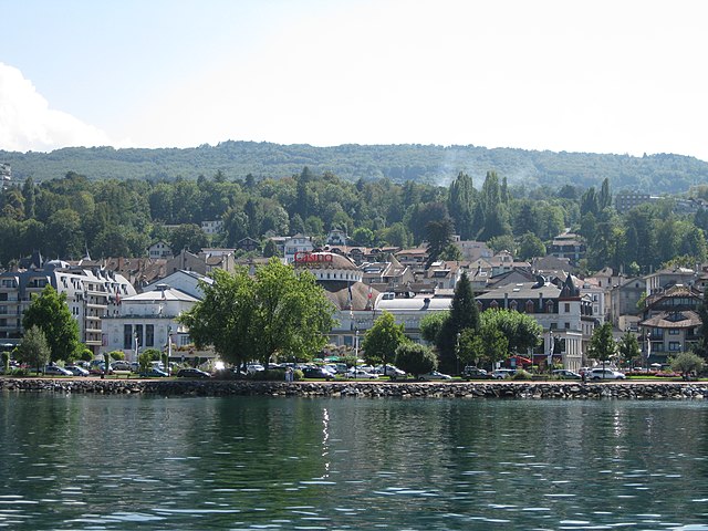
Пюблье (Publier, Publier)

- коммуна во Франции
 Hiking in Пюблье
Publier, located in the Haute-Savoie region of France, near the shores of Lake Geneva, offers a variety of hiking opportunities that cater to all levels of hikers. The area is characterized by stunning landscapes, including mountains, forests, and beautiful views of the lake.
Popular Hiking Trails:
-
Sentier des Fées: This scenic trail winds through the forest and is perfect for families. It includes educational signs about the local flora and fauna.
-
Lac de Montriond: A bit further from Publier, this hike leads to a picturesque lake surrounded by mountains. The route offers stunning views and is particularly beautiful in the summer.
-
Le Mont Billiat: For those looking for a challenge, this hike rewards climbers with panoramic views of Lake Geneva and the Alps. The trail is steep and requires a good level of fitness.
Best Time to Hike:
- Spring and Fall: These seasons offer mild temperatures and beautiful flora. Spring is particularly lovely with blooming wildflowers, while fall showcases vibrant autumn colors.
- Summer: Ideal for those who enjoy warm weather and longer days, but be prepared for more hikers on popular trails.
Tips for Hiking in Publier:
- Wear appropriate footwear: Hiking shoes or boots are essential for comfort and safety on varied terrain.
- Stay hydrated: Always carry enough water, especially on longer trails.
- Check the weather: Conditions can change quickly in the mountains, so be prepared with layers and waterproof gear if necessary.
- Respect local wildlife: Observe animals from a distance and stay on marked trails to minimize your impact on the environment.
Additional Activities:
In addition to hiking, the region offers activities such as kayaking on Lake Geneva, mountain biking, and winter sports in the nearby ski resorts during the colder months.
Whether you're seeking a leisurely hike or a challenging trek, Publier and its surroundings provide an excellent backdrop for outdoor enthusiasts. Always remember to plan ahead and enjoy the beauty of nature responsibly!
- Страна:

- Почтовый код: 74500
- Координаты: 46° 23' 16" N, 6° 32' 39" E


- GPS треки (wikiloc): [Ссылка]
- Площадь: 8.92 кв.км
- Население: 6912
- Веб сайт: http://www.ville-publier.fr/index.php?rubrique=1
- Википедия английская: wiki(en)
- Википедия национальная: wiki(fr)
- Хранилище Wikidata: Wikidata: Q680653
- Катеория в википедии: [Ссылка]
- код Freebase: [/m/03ntzrn]
- код GeoNames: Альт: [2985163]
- номер SIREN: [217402189]
- код BNF: [152744748]
- WOEID: [12668609]
- код муниципалитета INSEE: 74218
Граничит с регионами:


Тонон-ле-Бен
- коммуна во Франции
Hiking in Тонон-ле-Бен
Thonon-les-Bains, located on the shores of Lake Geneva in the Haute-Savoie region of France, offers a stunning backdrop for hiking enthusiasts. The area is characterized by its beautiful landscapes, which range from lakeside trails to the dramatic slopes of the nearby Alps. Here are some key highlights for hiking in and around Thonon-les-Bains:...
- Страна:
- Почтовый код: 74200
- Координаты: 46° 22' 14" N, 6° 28' 47" E
- GPS треки (wikiloc): [Ссылка]
- Высота над уровнем моря: 425 м m
- Площадь: 16.21 кв.км
- Население: 34895
- Веб сайт: [Ссылка]

Эвиан-ле-Бен
- коммуна во Франции
Hiking in Эвиан-ле-Бен
Évian-les-Bains, located on the shores of Lake Geneva in the Haute-Savoie region of France, is not only renowned for its healing thermal waters and stunning lakeside views but also offers a variety of hiking opportunities. Here are some highlights and tips for hiking in and around Évian-les-Bains:...
- Страна:
- Почтовый код: 74500
- Координаты: 46° 24' 2" N, 6° 35' 24" E
- GPS треки (wikiloc): [Ссылка]
- Площадь: 4.29 кв.км
- Население: 8968
- Веб сайт: [Ссылка]

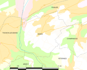
Марин
- коммуна и город во Франции, департамент Верхняя Савойя, регион Рона-Альпы
Hiking in Марин
Hiking in Marin, Haute-Savoie, France, offers breathtaking views and a variety of trails for outdoor enthusiasts. This region, nestled in the French Alps, is renowned for its stunning natural landscapes, including mountains, lakes, and valleys....
- Страна:
- Почтовый код: 74200
- Координаты: 46° 22' 35" N, 6° 31' 45" E
- GPS треки (wikiloc): [Ссылка]
- Площадь: 5.57 кв.км
- Население: 1727
- Веб сайт: [Ссылка]


Champanges
- коммуна во Франции
Hiking in Champanges
Hiking in Champanges, a charming municipality located in the Haute-Savoie region of the French Alps, offers an array of stunning landscapes, charming villages, and panoramic views of the surrounding mountains, including Mont Blanc. Here are some highlights and considerations for hiking in this area:...
- Страна:
- Почтовый код: 74500
- Координаты: 46° 22' 16" N, 6° 33' 11" E
- GPS треки (wikiloc): [Ссылка]
- Площадь: 3.71 кв.км
- Население: 942
- Веб сайт: [Ссылка]

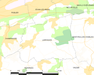
Larringes
- коммуна во Франции
Hiking in Larringes
Larringes is a charming village located in the Haute-Savoie region of France, near the shores of Lake Geneva. It offers several opportunities for hiking, with picturesque views of the surrounding mountains and the lake....
- Страна:
- Почтовый код: 74500
- Координаты: 46° 22' 7" N, 6° 34' 22" E
- GPS треки (wikiloc): [Ссылка]
- Площадь: 8.07 кв.км
- Население: 1351
- Веб сайт: [Ссылка]