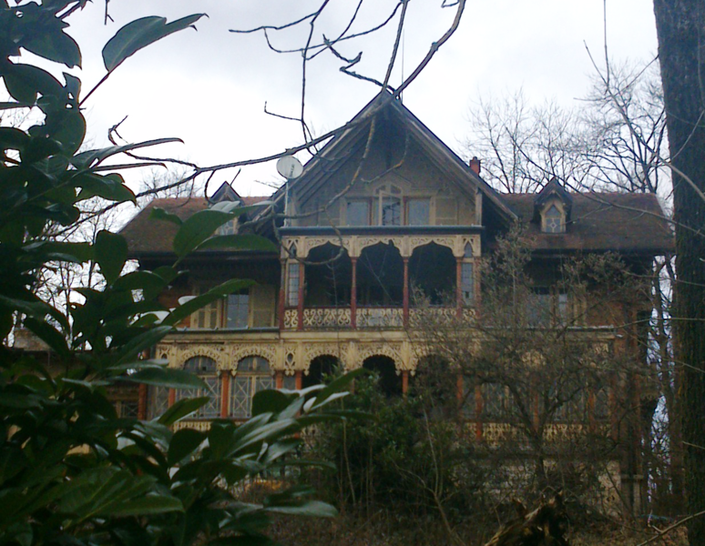
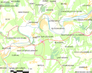
Rang (Rang)

- коммуна во Франции
 Hiking in Rang
Hiking in Rang, located in the Doubs department of France, offers a fantastic opportunity to explore the natural beauty of the Jura Mountains and the surrounding landscapes. The area is known for its stunning scenery, diverse wildlife, and numerous trails that cater to all levels of hikers.
Key Highlights:
-
Scenic Trails: Rang has a variety of hiking trails that take you through lush forests, past breathtaking viewpoints, and alongside rivers and streams. Some popular trails may lead to high ridges with stunning panoramas of the surrounding valleys and mountains.
-
Wildlife and Flora: The Doubs region is rich in biodiversity. While hiking, you may encounter diverse plant species, as well as wildlife such as deer, foxes, and a variety of bird species. Be sure to take your camera for the stunning natural scenes!
-
Lac de Saint-Point: Close to Rang, you can explore the beautiful Lac de Saint-Point, which is great for hiking as well as enjoying a range of outdoor activities, including picnicking and swimming.
-
Historical Sites: The region has historical charm with small villages and local architecture. You can incorporate visits to small towns and cafés along your hike, allowing for breaks and cultural enrichment.
-
Local Recommendations: Engage with local hiking groups or guides for the best trails and tips on conditions, as they may have insights on lesser-known paths that showcase the area's hidden gems.
Preparation Tips:
- Maps and Guides: Consider bringing a topographical map or a hiking app to help navigate the trails, as well as to check for trail conditions.
- Gear: Dress in layers and wear sturdy hiking boots. The weather can change quickly in the mountains, so being prepared is essential.
- Hydration and Snacks: Always carry enough water and snacks to keep your energy levels up while hiking.
- Respect Nature: Follow Leave No Trace principles by staying on designated paths and not disturbing wildlife.
Hiking in Rang, Doubs, can be an enriching experience, combining physical activity with the chance to connect with nature and explore the cultural aspects of the region. Enjoy your adventures!
- Страна:

- Почтовый код: 25250
- Координаты: 47° 25' 35" N, 6° 33' 46" E


- GPS треки (wikiloc): [Ссылка]
- Площадь: 10.32 кв.км
- Население: 420
- Википедия английская: wiki(en)
- Википедия национальная: wiki(fr)
- Хранилище Wikidata: Wikidata: Q923322
- Катеория в википедии: [Ссылка]
- код Freebase: [/m/03nnk5y]
- код Freebase: [/m/03nnk5y]
- код GeoNames: Альт: [6429953]
- код GeoNames: Альт: [6429953]
- номер SIREN: [212504799]
- номер SIREN: [212504799]
- код BNF: [15252705c]
- код BNF: [15252705c]
- код муниципалитета INSEE: 25479
- код муниципалитета INSEE: 25479
Граничит с регионами:


Anteuil
- коммуна во Франции
Hiking in Anteuil
Anteuil is a small commune in the Doubs department in eastern France. While it might not be as widely recognized for hiking as some larger national parks or regions, it offers beautiful landscapes typical of the Jura foothills. Here are some things to consider when hiking in and around Anteuil:...
- Страна:
- Почтовый код: 25340
- Координаты: 47° 23' 15" N, 6° 33' 39" E
- GPS треки (wikiloc): [Ссылка]
- Площадь: 24.29 кв.км
- Население: 661

Appenans
- коммуна во Франции
Hiking in Appenans
Hiking in the Apennines can be a wonderful experience, offering a range of landscapes, from lush green valleys to rugged peaks. The Apennine Mountain range stretches down the spine of Italy, running approximately 1,200 kilometers (750 miles) from the northern regions to the southern tip of the peninsula. Here’s what you should know about hiking in this beautiful area:...
- Страна:
- Почтовый код: 25250
- Координаты: 47° 26' 34" N, 6° 33' 54" E
- GPS треки (wikiloc): [Ссылка]
- Высота над уровнем моря: 290 м m
- Площадь: 4.07 кв.км
- Население: 384


Mancenans
- коммуна во Франции
Hiking in Mancenans
Mancenans is a small commune located in the Doubs department in the Bourgogne-Franche-Comté region of eastern France. While it may not be as widely known as some larger hiking destinations, Mancenans and its surrounding areas offer beautiful landscapes and opportunities for outdoor activities, including hiking....
- Страна:
- Почтовый код: 25250
- Координаты: 47° 27' 15" N, 6° 32' 34" E
- GPS треки (wikiloc): [Ссылка]
- Высота над уровнем моря: 756 м m
- Площадь: 11.94 кв.км
- Население: 317


Pompierre-sur-Doubs
- коммуна во Франции
Hiking in Pompierre-sur-Doubs
Pompierre-sur-Doubs is a picturesque village located in the Doubs department in the Bourgogne-Franche-Comté region of France. The area offers beautiful natural scenery, making it a suitable destination for hiking enthusiasts. Here are some highlights and tips for hiking in and around Pompierre-sur-Doubs:...
- Страна:
- Почтовый код: 25340
- Координаты: 47° 25' 7" N, 6° 31' 27" E
- GPS треки (wikiloc): [Ссылка]
- Площадь: 8.16 кв.км
- Население: 304

л'Иль-сюр-ле-Ду
- коммуна во Франции
Hiking in л'Иль-сюр-ле-Ду
L'Isle-sur-le-Doubs, located in the Doubs department of France, offers a delightful hiking experience amidst beautiful natural scenery. Sitting along the Doubs River, this area features diverse landscapes, including forests, hills, and riversides, making it perfect for outdoor enthusiasts....
- Страна:
- Почтовый код: 25250
- Координаты: 47° 26' 52" N, 6° 35' 10" E
- GPS треки (wikiloc): [Ссылка]
- Площадь: 10.67 кв.км
- Население: 3078
- Веб сайт: [Ссылка]

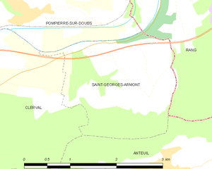
Saint-Georges-Armont
- коммуна во Франции
Hiking in Saint-Georges-Armont
Saint-Georges-Armont, located in the picturesque Vosges region of France, offers a unique hiking experience amidst beautiful landscapes. The area is characterized by rolling hills, dense forests, and panoramic views of the surrounding countryside. Here are some highlights and tips for hiking in this region:...
- Страна:
- Почтовый код: 25340
- Координаты: 47° 23' 56" N, 6° 33' 25" E
- GPS треки (wikiloc): [Ссылка]
- Площадь: 4.74 кв.км
- Население: 118