Anteuil (Anteuil)

- коммуна во Франции
 Hiking in Anteuil
Anteuil is a small commune in the Doubs department in eastern France. While it might not be as widely recognized for hiking as some larger national parks or regions, it offers beautiful landscapes typical of the Jura foothills. Here are some things to consider when hiking in and around Anteuil:
Trails and Nature
- Scenic Landscape: The region around Anteuil features diverse terrain, including rolling hills, lush forests, and scenic vistas, making it ideal for nature lovers.
- Local Trails: There are probably numerous local walking and hiking trails. It's worth checking regional maps or local tourism information for information on marked paths.
Flora and Fauna
- Biodiversity: The Jura region is known for its rich biodiversity. While hiking, you may encounter various animal species and plants native to the area, especially in the protected areas.
Safety and Preparation
- Weather Conditions: The weather can change quickly in the mountains, so it's important to check forecasts and be prepared for varying conditions.
- Gear: Good hiking boots, weather-appropriate clothing, and a plan for hydration and nutrition are essential.
Local Attractions
- Cultural Sites: In addition to the natural beauty, look out for historical sites and local culture, including charming villages and traditional architecture.
- Accessibility: Depending on your starting point, ensure you have a means of transportation to popular trailheads or points of interest.
Tips
- Maps: Keep a regional hiking map on hand to navigate the trails easily.
- Guided Tours: If unsure about exploring alone, consider joining a guided hiking tour to learn more about the area.
Whether you're looking for a casual walk or a more strenuous hike, Anteuil and its surroundings can provide a lovely outdoor experience.
- Страна:

- Почтовый код: 25340
- Координаты: 47° 23' 15" N, 6° 33' 39" E


- GPS треки (wikiloc): [Ссылка]
- Площадь: 24.29 кв.км
- Население: 661
- Википедия английская: wiki(en)
- Википедия национальная: wiki(fr)
- Хранилище Wikidata: Wikidata: Q572187
- Катеория в википедии: [Ссылка]
- код Freebase: [/m/03mgbkw]
- код Freebase: [/m/03mgbkw]
- код GeoNames: Альт: [3037470]
- код GeoNames: Альт: [3037470]
- номер SIREN: [212500185]
- номер SIREN: [212500185]
- код BNF: [15252244w]
- код BNF: [15252244w]
- код муниципалитета INSEE: 25018
- код муниципалитета INSEE: 25018
Граничит с регионами:


Chaux-lès-Clerval
- коммуна во Франции
Hiking in Chaux-lès-Clerval
Chaux-lès-Clerval is a small commune located in the Doubs department in the Bourgogne-Franche-Comté region of eastern France. The surrounding landscape offers beautiful natural scenery that can be quite enjoyable for hikers....
- Страна:
- Почтовый код: 25340
- Координаты: 47° 22' 58" N, 6° 30' 28" E
- GPS треки (wikiloc): [Ссылка]
- Площадь: 8.57 кв.км
- Население: 156

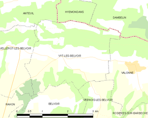
Vyt-lès-Belvoir
- коммуна во Франции
Hiking in Vyt-lès-Belvoir
Vyt-lès-Belvoir is a small commune located in the Doubs department in the Bourgogne-Franche-Comté region of eastern France. The area is known for its picturesque landscapes, dense forests, and charming countryside, making it a great place for hiking enthusiasts....
- Страна:
- Почтовый код: 25430
- Координаты: 47° 20' 54" N, 6° 37' 18" E
- GPS треки (wikiloc): [Ссылка]
- Площадь: 7.54 кв.км
- Население: 187


Clerval
- коммуна во Франции
Hiking in Clerval
Clerval, located in the Doubs department of the Bourgogne-Franche-Comté region in eastern France, offers a charming backdrop for hiking enthusiasts. The area is rich in natural beauty, with rolling hills, forests, and the scenic Doubs River winding through the landscape....
- Страна:
- Почтовый код: 25340
- Координаты: 47° 23' 32" N, 6° 29' 51" E
- GPS треки (wikiloc): [Ссылка]
- Площадь: 11.83 кв.км
- Население: 1035


Hyémondans
- коммуна во Франции
Hiking in Hyémondans
Hyémondans is a charming location for hiking enthusiasts, offering both beautiful scenery and a variety of trails suited for different skill levels. Nestled in the region of Doubs in France, it's characterized by rolling hills, dense forests, and breathtaking views of the surrounding landscape....
- Страна:
- Почтовый код: 25250
- Координаты: 47° 23' 15" N, 6° 38' 58" E
- GPS треки (wikiloc): [Ссылка]
- Площадь: 6.87 кв.км
- Население: 194


Blussans
- коммуна во Франции
Hiking in Blussans
Blussans is a picturesque village located in the Jura region of France, known for its beautiful landscapes and outdoor activities, including hiking. Here are some key aspects of hiking in Blussans:...
- Страна:
- Почтовый код: 25250
- Координаты: 47° 25' 39" N, 6° 36' 26" E
- GPS треки (wikiloc): [Ссылка]
- Площадь: 8.04 кв.км
- Население: 196


Crosey-le-Grand
- коммуна во Франции
Hiking in Crosey-le-Grand
Crosey-le-Grand is a charming village located in the Doubs department in the Bourgogne-Franche-Comté region of eastern France. The area surrounding Crosey-le-Grand is known for its beautiful natural landscapes, making it a great destination for hiking enthusiasts....
- Страна:
- Почтовый код: 25340
- Координаты: 47° 21' 20" N, 6° 31' 30" E
- GPS треки (wikiloc): [Ссылка]
- Площадь: 10.28 кв.км
- Население: 156


Lanthenans
- коммуна во Франции
Hiking in Lanthenans
Lantheans, located in the picturesque region of France, offers exceptional hiking opportunities for outdoor enthusiasts of all skill levels. The landscape features a blend of dense forests, rolling hills, and stunning vistas. Here are some highlights and tips for hiking in the area:...
- Страна:
- Почтовый код: 25250
- Координаты: 47° 23' 41" N, 6° 37' 38" E
- GPS треки (wikiloc): [Ссылка]
- Площадь: 3.36 кв.км
- Население: 68


Vellerot-lès-Belvoir
- коммуна во Франции
Hiking in Vellerot-lès-Belvoir
Vellerot-lès-Belvoir is a picturesque village located in the Doubs department of the Bourgogne-Franche-Comté region in eastern France. While it may not be as widely known as some other hiking destinations, it offers a charming landscape and opportunities for outdoor activities, particularly for those who enjoy hiking in more tranquil settings....
- Страна:
- Почтовый код: 25430
- Координаты: 47° 21' 1" N, 6° 36' 5" E
- GPS треки (wikiloc): [Ссылка]
- Площадь: 6.04 кв.км
- Население: 102


Orve
- коммуна во Франции
Hiking in Orve
Hiking in Orve, a scenic region in Switzerland, is a delightful experience for outdoor enthusiasts. The picturesque landscapes, characterized by rolling hills, lush forests, and stunning views of the Alps, provide a variety of trails suitable for all skill levels....
- Страна:
- Почтовый код: 25430
- Координаты: 47° 19' 33" N, 6° 33' 14" E
- GPS треки (wikiloc): [Ссылка]
- Площадь: 5.51 кв.км
- Население: 67

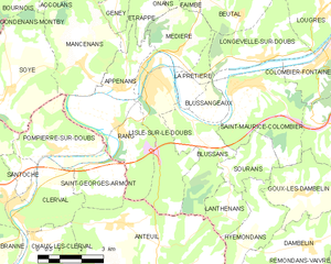
л'Иль-сюр-ле-Ду
- коммуна во Франции
Hiking in л'Иль-сюр-ле-Ду
L'Isle-sur-le-Doubs, located in the Doubs department of France, offers a delightful hiking experience amidst beautiful natural scenery. Sitting along the Doubs River, this area features diverse landscapes, including forests, hills, and riversides, making it perfect for outdoor enthusiasts....
- Страна:
- Почтовый код: 25250
- Координаты: 47° 26' 52" N, 6° 35' 10" E
- GPS треки (wikiloc): [Ссылка]
- Площадь: 10.67 кв.км
- Население: 3078
- Веб сайт: [Ссылка]


Rang
- коммуна во Франции
Hiking in Rang
Hiking in Rang, located in the Doubs department of France, offers a fantastic opportunity to explore the natural beauty of the Jura Mountains and the surrounding landscapes. The area is known for its stunning scenery, diverse wildlife, and numerous trails that cater to all levels of hikers....
- Страна:
- Почтовый код: 25250
- Координаты: 47° 25' 35" N, 6° 33' 46" E
- GPS треки (wikiloc): [Ссылка]
- Площадь: 10.32 кв.км
- Население: 420

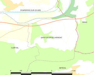
Saint-Georges-Armont
- коммуна во Франции
Hiking in Saint-Georges-Armont
Saint-Georges-Armont, located in the picturesque Vosges region of France, offers a unique hiking experience amidst beautiful landscapes. The area is characterized by rolling hills, dense forests, and panoramic views of the surrounding countryside. Here are some highlights and tips for hiking in this region:...
- Страна:
- Почтовый код: 25340
- Координаты: 47° 23' 56" N, 6° 33' 25" E
- GPS треки (wikiloc): [Ссылка]
- Площадь: 4.74 кв.км
- Население: 118