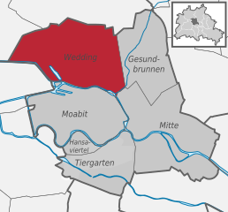
Райниккендорф (Reinickendorf, Reinickendorf)

- район в одноимённом округе Берлина
 Hiking in Райниккендорф
Reinickendorf is a district located in the northern part of Berlin, Germany. While it's primarily an urban area, it offers several opportunities for hiking and outdoor activities, particularly in its parks and natural reserves.
Key Hiking Areas in Reinickendorf:
-
Tegeler Forest (Tegelort):
- This large forest area offers numerous walking and hiking trails. You can enjoy a mix of forested paths and lakeside views, particularly around the Tegeler See. Trails vary in difficulty, making it suitable for both casual walkers and more experienced hikers.
-
Tegeler See:
- The lakeside path around Tegeler See provides beautiful views and a chance to enjoy nature. It's perfect for a more leisurely hike, and there are spots to rest or picnic along the way.
-
Plötzensee:
- This is a smaller lake surrounded by a park. The area offers well-maintained paths that are ideal for a short hike or a stroll. It's a peaceful location, perfect for families.
-
Schumacher Park:
- This park features walking paths, playgrounds, and green spaces for a quick hike or a relaxed outdoor experience. It's a good place for families or those looking for a shorter trail.
-
Local Trails:
- Several residential areas have interconnected walking paths that lead through gardens, parks, and small forested areas, allowing for urban hiking experiences.
Hiking Tips:
- Map it Out: Familiarize yourself with the local trail maps, which are often available online or at local tourist offices.
- Check the Weather: Berlin's weather can be variable; dress appropriately for changing conditions.
- Stay Hydrated: Always carry water, especially during warmer months.
- Footwear: Wear comfortable hiking shoes to ensure good support and grip on the various surfaces.
- Wildlife: Keep an eye out for local wildlife, particularly in wooded and lakeside areas.
While Reinickendorf may not offer the extensive hiking opportunities of larger natural reserves, it provides a convenient escape into nature within the urban setting of Berlin. Whether you're looking for a quick walk or a longer hike, you can find enjoyable routes in and around this district.
- Страна:

- Почтовый код: 13409; 13407; 13403
- Координаты: 52° 34' 0" N, 13° 20' 0" E


- GPS треки (wikiloc): [Ссылка]
- Высота над уровнем моря: 42 м m
- Площадь: 10.5 кв.км
- Население: 80687
- Википедия русская: wiki(ru)
- Википедия английская: wiki(en)
- Википедия национальная: wiki(de)
- Хранилище Wikidata: Wikidata: Q694034
- Галерея изображений в википедии: [Ссылка]
- Катеория в википедии: [Ссылка]
- Карты в википедии: [Ссылка]
- код Freebase: [/m/05zngx8]
- код GeoNames: Альт: [2848756]
- ID отношения в OpenStreetMap: [16328]
- идентификатор местоположения ArchINFORM: [3596]
Граничит с регионами:


Панков
- район в одноимённом округе в Берлине
Hiking in Панков
Pankow is a district in northeastern Berlin, Germany, known for its charming neighborhoods, parks, and green areas. While it is more urban compared to rural hiking destinations, there are still opportunities for enjoyable walks and hikes within and around the area....
- Страна:
- Координаты: 52° 34' 0" N, 13° 24' 0" E
- GPS треки (wikiloc): [Ссылка]
- Высота над уровнем моря: 47 м m
- Площадь: 5.66 кв.км
- Население: 57113


Нидершёнхаузен
- район в Берлине
Hiking in Нидершёнхаузен
Niederschönhausen is a district located in the Pankow borough of Berlin, Germany. While it may not be as widely known for hiking as some of the more rural areas surrounding Berlin, there are still opportunities for walks and nature exploration in and around the area....
- Страна:
- Координаты: 52° 35' 0" N, 13° 24' 0" E
- GPS треки (wikiloc): [Ссылка]
- Высота над уровнем моря: 48 м m
- Площадь: 6.49 кв.км
- Население: 28313


Виттенау
- район в Берлине
Hiking in Виттенау
Wittenau is a district in the borough of Reinickendorf in Berlin, Germany. While Wittenau itself is primarily urban and residential, it offers some walking and hiking opportunities, especially in nearby parks and natural areas....
- Страна:
- Почтовый код: 13469; 13439; 13437; 13435
- Координаты: 52° 35' 31" N, 13° 19' 35" E
- GPS треки (wikiloc): [Ссылка]
- Высота над уровнем моря: 41 м m
- Площадь: 5.9 кв.км
- Население: 25118

Гезундбруннен
- район в Берлине
Hiking in Гезундбруннен
Gesundbrunnen is a neighborhood in Berlin, known more for its urban environment than traditional hiking trails. However, there are options for those looking to enjoy the outdoors and some nature walks in and around the area. Here are a few recommendations:...
- Страна:
- Почтовый код: 13409; 13359; 13357; 13355; 13353; 13347
- Координаты: 52° 32' 55" N, 13° 23' 25" E
- GPS треки (wikiloc): [Ссылка]
- Высота над уровнем моря: 53 м m
- Площадь: 6.13 кв.км
- Население: 90748


Вильгельмсру
- район в Берлине
Hiking in Вильгельмсру
Wilhelmsruh is a charming area located in Berlin, Germany, known for its natural beauty and peaceful surroundings. Though it may not be as prominent as some of the larger hiking destinations, it offers a unique blend of urban and natural landscapes, making it a fantastic spot for walking and light hiking....
- Страна:
- Координаты: 52° 35' 14" N, 13° 22' 5" E
- GPS треки (wikiloc): [Ссылка]
- Высота над уровнем моря: 44 м m
- Площадь: 1.37 кв.км

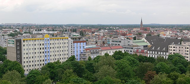
Веддинг
- район Берлина
Hiking in Веддинг
Hiking in Wedding, a district in the borough of Mitte, Berlin, might not be the first thing that comes to mind when you think of hiking, as it is primarily an urban area. However, there are several parks and green spaces within and around Wedding where you can enjoy short hikes or leisurely walks....
- Страна:
- Почтовый код: 13407; 13359; 13357; 13353; 13351; 13349; 13347
- Координаты: 52° 33' 0" N, 13° 22' 0" E
- GPS треки (wikiloc): [Ссылка]
- Высота над уровнем моря: 41 м m
- Площадь: 9.23 кв.км
- Население: 83612


Тегель
- район в Берлине
Hiking in Тегель
Tegel, located in the northern part of Berlin, Germany, is known for its beautiful natural surroundings, including lakes and forests, making it a great area for hiking and outdoor activities. Here are some highlights and tips for hiking in the Tegel area:...
- Страна:
- Почтовый код: 13509; 13507; 13505; 13503; 13405
- Координаты: 52° 35' 0" N, 13° 17' 0" E
- GPS треки (wikiloc): [Ссылка]
- Высота над уровнем моря: 36 м m
- Площадь: 33.7 кв.км
- Население: 35474