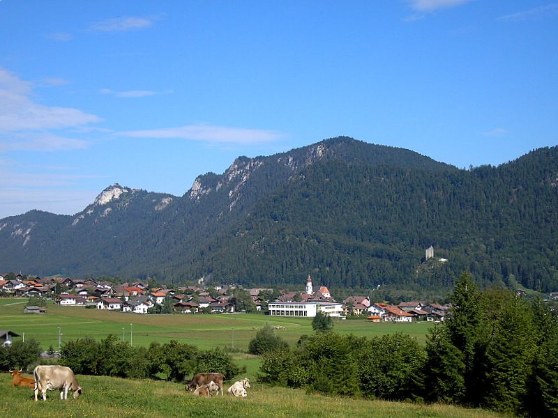
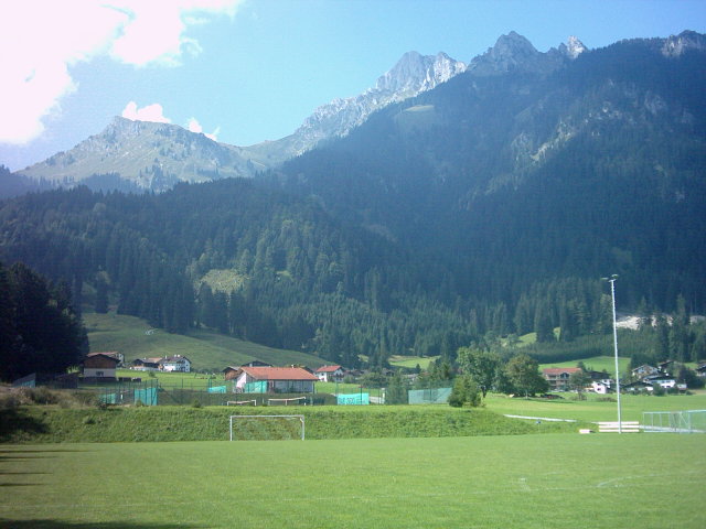
Ройтте (округ) (Reutte District, Bezirk Reutte)
 Hiking in Ройтте (округ)
The Reutte District, located in the Tyrol region of Austria, is known for its stunning natural landscapes, charming villages, and a variety of hiking trails suitable for all levels of hikers. Here are some key aspects of hiking in this area:
Trails and Routes
-
Hiking Difficulty: The area offers a range of trails from easy walks suitable for families to more challenging mountain hikes. You can find marked trails that cater to both beginners and experienced hikers.
-
Popular Trails:
- Lechtal Valley: A picturesque area with numerous trails that offer breathtaking views of the Lechtal Alps. The trails here can vary in difficulty.
- Highline165: Near the area, this suspension bridge offers stunning views and access to hiking paths that allow you to explore the surroundings.
- Hiking to the Zugspitze: This well-known peak near the Reutte District offers numerous trails leading to its summit; it's one of the most popular hiking destinations.
-
The Plansee: This beautiful lake is surrounded by hiking trails that provide scenic views and opportunities for swimming or picnicking.
Natural Highlights
- Austrian Alps: Hiking in Reutte gives you the opportunity to experience the diverse flora and fauna of the Austrian Alps.
- Waterfalls and Lakes: The region is dotted with beautiful lakes and waterfalls, such as the famous Wasserfall in the nearby village of Elmen.
Seasonal Considerations
- Summer Hiking: The best time for hiking is typically from late spring to early autumn (May to September) when the weather is pleasant, and the trails are fully accessible.
- Winter Hiking: Some trails remain open for winter hiking, and the area also offers snowshoeing and cross-country skiing opportunities.
Tips for Hikers
- Gear: Ensure you're equipped with suitable hiking gear including sturdy footwear, layered clothing, and plenty of water.
- Maps and Signage: Trails are generally well-marked, but carrying a detailed map or a GPS device is advisable.
- Local Guides: Consider hiring a local guide for more challenging hikes or to get insight into the region’s history and ecology.
Local Attractions
- Beyond hiking, the Reutte District features attractions like the Ehrenberg Castle, which is rich in history, and the charming village atmosphere typical of Tyrol.
Overall, hiking in the Reutte District is a fantastic way to enjoy the natural beauty of Austria while getting some exercise and experiencing the culture of the region. Always check local resources for trail status and weather conditions before heading out.
- Страна:

- Столица: Ройтте
- Код автомобильного номера: RE
- Координаты: 47° 24' 0" N, 10° 30' 0" E


- GPS треки (wikiloc): [Ссылка]
- Высота над уровнем моря: 1222 м m
- Площадь: 1236.82 кв.км
- Население: 32023
- Веб сайт: http://www.tirol.gv.at/bh-reutte
- Википедия русская: wiki(ru)
- Википедия английская: wiki(en)
- Википедия национальная: wiki(de)
- Хранилище Wikidata: Wikidata: Q854005
- Катеория в википедии: [Ссылка]
- Карты в википедии: [Ссылка]
- код Freebase: [/m/06sk08]
- код GeoNames: Альт: [2767510]
- код VIAF: Альт: [242083941]
- код GND: Альт: [4049663-6]
- идентификатор местоположения ArchINFORM: [14621]
Включает регионы:

Цёблен
Hiking in Цёблен
Zöblen is a charming village located in the Tyrolean region of Austria, nestled in the beautiful Tannheimer Valley. This area is renowned for its stunning alpine scenery, making it an excellent destination for hiking enthusiasts. Here’s what you can expect when hiking in and around Zöblen:...
- Страна:
- Почтовый код: 6677
- Телефонный код: 05675
- Код автомобильного номера: RE
- Координаты: 47° 30' 27" N, 10° 28' 42" E
- GPS треки (wikiloc): [Ссылка]
- Высота над уровнем моря: 1087 м m
- Площадь: 8.8 кв.км
- Население: 231
- Веб сайт: [Ссылка]
Фильс
- муниципалитет в Австрии, Тироль, Ройтте
Hiking in Фильс
Vils, located in Tyrol, Austria, is a charming village that serves as a great starting point for various hiking adventures in the surrounding region. It is set against a stunning mountain backdrop and surrounded by beautiful landscapes, making it an excellent destination for hikers of all skill levels....
- Страна:
- Почтовый код: 6682
- Телефонный код: 05677
- Код автомобильного номера: RE
- Координаты: 47° 32' 58" N, 10° 37' 48" E
- GPS треки (wikiloc): [Ссылка]
- Высота над уровнем моря: 826 м m
- Площадь: 30.77 кв.км
- Население: 1535
- Веб сайт: [Ссылка]


Форхах
Hiking in Форхах
Forchach is a beautiful area located in the Tyrol region of Austria, known for its stunning natural landscapes, which include alpine meadows, forests, and panoramic mountain views. Here are some highlights and tips for hiking in and around Forchach:...
- Страна:
- Почтовый код: 6670
- Телефонный код: 05632
- Код автомобильного номера: RE
- Координаты: 47° 25' 21" N, 10° 35' 32" E
- GPS треки (wikiloc): [Ссылка]
- Высота над уровнем моря: 910 м m
- Площадь: 14.4 кв.км
- Население: 259
- Веб сайт: [Ссылка]
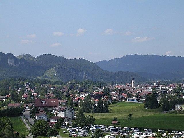

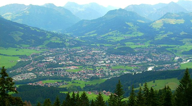
Ройтте
Hiking in Ройтте
Reutte, located in the Tyrolean region of Austria, is a fantastic destination for hiking enthusiasts. Nestled in the foothills of the Alps, Reutte offers a stunning landscape characterized by mountains, valleys, and picturesque villages. Here are some highlights about hiking in the area:...
- Страна:
- Почтовый код: 6600
- Телефонный код: 05672
- Код автомобильного номера: RE
- Координаты: 47° 29' 0" N, 10° 43' 0" E
- GPS треки (wikiloc): [Ссылка]
- Высота над уровнем моря: 853 м m
- Площадь: 100.9 кв.км
- Население: 6704
- Веб сайт: [Ссылка]

Брайтенванг
Hiking in Брайтенванг
Breitenwang, located in the Tyrol region of Austria, is a charming village that offers a variety of hiking opportunities, especially given its proximity to the stunning Lechtal Alps and the scenic landscape of the area. Here's what you need to know about hiking in Breitenwang:...
- Страна:
- Почтовый код: 6600
- Телефонный код: 05672
- Код автомобильного номера: RE
- Координаты: 47° 29' 20" N, 10° 43' 40" E
- GPS треки (wikiloc): [Ссылка]
- Высота над уровнем моря: 850 м m
- Площадь: 18.9 кв.км
- Население: 1423
- Веб сайт: [Ссылка]

Эрвальд
Hiking in Эрвальд
Ehrwald is a picturesque village located in the Tyrolean Alps of Austria, near the border with Germany. It's a fantastic destination for hiking enthusiasts, offering a range of trails suitable for all skill levels, from leisurely walks to challenging mountain hikes. Here are some highlights of hiking in Ehrwald:...
- Страна:
- Почтовый код: 6632
- Телефонный код: 05673
- Код автомобильного номера: RE
- Координаты: 47° 23' 59" N, 10° 55' 0" E
- GPS треки (wikiloc): [Ссылка]
- Высота над уровнем моря: 994 м m
- Площадь: 49.4 кв.км
- Население: 2593
- Веб сайт: [Ссылка]

Эльбигенальп
Hiking in Эльбигенальп
Elbigenalp is a charming village situated in the beautiful Lechtal Valley of Tyrol, Austria. It's surrounded by stunning alpine scenery, making it an excellent destination for hiking enthusiasts. Here are some key features and highlights of hiking in Elbigenalp:...
- Страна:
- Почтовый код: 6652
- Телефонный код: 05634
- Код автомобильного номера: RE
- Координаты: 47° 17' 28" N, 10° 26' 21" E
- GPS треки (wikiloc): [Ссылка]
- Высота над уровнем моря: 1039 м m
- Площадь: 33.09 кв.км
- Население: 889
- Веб сайт: [Ссылка]
Ээнбихль
- коммуна в земле Тироль (Австрия)
Hiking in Ээнбихль
Ehenbichl is a small village located near the beautiful Austrian town of Reutte in the Tyrol region. It is an excellent starting point for hiking enthusiasts due to its proximity to the majestic peaks of the Alps and a variety of well-marked trails that cater to different skill levels....
- Страна:
- Почтовый код: 6600
- Телефонный код: 05672
- Код автомобильного номера: RE
- Координаты: 47° 28' 21" N, 10° 42' 16" E
- GPS треки (wikiloc): [Ссылка]
- Высота над уровнем моря: 862 м m
- Площадь: 7.3 кв.км
- Население: 824
- Веб сайт: [Ссылка]


Бах
- коммуна в Австрии, в федеральной земле Тироль
Hiking in Бах
Bach, Austria, is a picturesque village located in the Tyrol region, nestled within the beautiful mountain landscapes of the Austrian Alps. It serves as a great base for hiking enthusiasts looking to explore stunning natural scenery, alpine meadows, and serene lakes....
- Страна:
- Почтовый код: 6653
- Телефонный код: 05634
- Код автомобильного номера: RE
- Координаты: 47° 16' 0" N, 10° 24' 0" E
- GPS треки (wikiloc): [Ссылка]
- Высота над уровнем моря: 1070 м m
- Площадь: 56.9 кв.км
- Население: 614
- Веб сайт: [Ссылка]
Пинсванг
Hiking in Пинсванг
Pinswang, a picturesque village in the Tyrol region of Austria, offers a variety of hiking opportunities that cater to different skill levels. Nestled near the German border and surrounded by the breathtaking landscapes of the Alps, it's an excellent destination for outdoor enthusiasts....
- Страна:
- Почтовый код: 6600
- Телефонный код: 05677
- Код автомобильного номера: RE
- Координаты: 47° 32' 39" N, 10° 40' 23" E
- GPS треки (wikiloc): [Ссылка]
- Высота над уровнем моря: 824 м m
- Площадь: 9.47 кв.км
- Население: 412
- Веб сайт: [Ссылка]

Хезельгер
Hiking in Хезельгер
Häselgehr is a charming village in the region of Tyrol, Austria, surrounded by stunning alpine landscapes. Hiking in this area offers a variety of trails suitable for different skill levels, making it an attractive destination for outdoor enthusiasts....
- Страна:
- Почтовый код: 6651
- Телефонный код: 05634
- Код автомобильного номера: RE
- Координаты: 47° 18' 30" N, 10° 29' 30" E
- GPS треки (wikiloc): [Ссылка]
- Высота над уровнем моря: 1006 м m
- Площадь: 50.6 кв.км
- Население: 690
- Веб сайт: [Ссылка]
Штег
Hiking in Штег
Steeg, located in the Tyrol region of Austria, is a fantastic destination for hiking enthusiasts. Nestled within the beautiful Lechtal Alps, it offers a variety of trails suitable for hikers of all levels. Here are some highlights and considerations for hiking in Steeg:...
- Страна:
- Почтовый код: 6655
- Телефонный код: 05633
- Код автомобильного номера: RE
- Координаты: 47° 14' 33" N, 10° 17' 40" E
- GPS треки (wikiloc): [Ссылка]
- Высота над уровнем моря: 1122 м m
- Площадь: 68 кв.км
- Население: 671
- Веб сайт: [Ссылка]


Лермос
Hiking in Лермос
Lermoos is a picturesque village located in the Tyrol region of Austria, nestled at the foot of the Zugspitze, which is the highest peak in Germany. It offers a stunning backdrop for hiking enthusiasts, with a wide variety of trails that cater to different skill levels. Here’s what you need to know about hiking in Lermoos:...
- Страна:
- Почтовый код: 6631
- Телефонный код: 05673
- Код автомобильного номера: RE
- Координаты: 47° 24' 0" N, 10° 53' 0" E
- GPS треки (wikiloc): [Ссылка]
- Высота над уровнем моря: 1004 м m
- Площадь: 56.4 кв.км
- Население: 1156
- Веб сайт: [Ссылка]

Бибервир
Hiking in Бибервир
Biberwier, located in the Tyrolean region of Austria, is a stunning destination for hiking enthusiasts. Situated at the foot of the majestic Zugspitze mountain, the area offers a variety of trails that cater to different skill levels, making it suitable for families, beginners, and experienced hikers alike....
- Страна:
- Почтовый код: 6633
- Телефонный код: 05673
- Код автомобильного номера: RE
- Координаты: 47° 23' 0" N, 10° 53' 34" E
- GPS треки (wikiloc): [Ссылка]
- Высота над уровнем моря: 989 м m
- Площадь: 29.4 кв.км
- Население: 628
- Веб сайт: [Ссылка]

Берванг
Hiking in Берванг
Berwang is a charming village located in the Tyrol region of Austria, nestled within the Zugspitz Arena. It’s a fantastic destination for hiking enthusiasts, offering numerous trails that cater to various skill levels, from leisurely walks to more challenging hikes. Here are some key highlights about hiking in Berwang:...
- Страна:
- Почтовый код: 6622
- Телефонный код: 05674
- Код автомобильного номера: RE
- Координаты: 47° 24' 28" N, 10° 44' 51" E
- GPS треки (wikiloc): [Ссылка]
- Высота над уровнем моря: 1342 м m
- Площадь: 42.7 кв.км
- Население: 565
- Веб сайт: [Ссылка]

Бихльбах
Hiking in Бихльбах
Bichlbach is a charming village located in the Tyrolean region of Austria, surrounded by the beautiful Ammergebirge and the Zugspitz Arena, making it a fantastic destination for hiking enthusiasts. Here are some key points about hiking in Bichlbach:...
- Страна:
- Почтовый код: 6621
- Телефонный код: 05674
- Код автомобильного номера: RE
- Координаты: 47° 25' 15" N, 10° 47' 29" E
- GPS треки (wikiloc): [Ссылка]
- Высота над уровнем моря: 1079 м m
- Площадь: 30.6 кв.км
- Население: 788
- Веб сайт: [Ссылка]

Пфаффлар
Hiking in Пфаффлар
Pfafflar is a picturesque village located in the Tyrol region of Austria, nestled in the beautiful Austrian Alps. This area offers a variety of hiking opportunities that cater to various skill levels, from gentle walks to more challenging trails. Here are some highlights of hiking in and around Pfafflar:...
- Страна:
- Почтовый код: 6647
- Телефонный код: 05635
- Код автомобильного номера: RE
- Координаты: 47° 17' 0" N, 10° 37' 0" E
- GPS треки (wikiloc): [Ссылка]
- Высота над уровнем моря: 1314 м m
- Площадь: 33.63 кв.км
- Население: 112
- Веб сайт: [Ссылка]

Хёфен
Hiking in Хёфен
Höfen is a charming village located in the Tyrol region of Austria, known for its breathtaking alpine scenery and a variety of hiking trails suitable for different skill levels. Here are some highlights and tips for hiking in Höfen:...
- Страна:
- Почтовый код: 6604
- Телефонный код: 05672
- Код автомобильного номера: RE
- Координаты: 47° 28' 16" N, 10° 41' 14" E
- GPS треки (wikiloc): [Ссылка]
- Высота над уровнем моря: 868 м m
- Площадь: 8.3 кв.км
- Население: 1200
- Веб сайт: [Ссылка]

Лехашау
Hiking in Лехашау
Lechaschau, located in Austria near the picturesque town of Reutte in Tyrol, offers a splendid backdrop for hiking enthusiasts. The area is characterized by its breathtaking alpine scenery, dense forests, and scenic mountain views, making it an attractive destination for outdoor activities throughout the year....
- Страна:
- Почтовый код: 6600
- Телефонный код: 05672
- Код автомобильного номера: RE
- Координаты: 47° 29' 23" N, 10° 42' 22" E
- GPS треки (wikiloc): [Ссылка]
- Высота над уровнем моря: 846 м m
- Площадь: 6.1 кв.км
- Население: 2108
- Веб сайт: [Ссылка]

Хинтерхорнбах
Hiking in Хинтерхорнбах
Hinterhornbach is a beautiful village located in the Tyrol region of Austria, near the border with Germany, and is known for its stunning natural scenery and excellent hiking opportunities. Here are some key points about hiking in Hinterhornbach:...
- Страна:
- Почтовый код: 6646
- Телефонный код: 05632
- Код автомобильного номера: RE
- Координаты: 47° 21' 28" N, 10° 27' 3" E
- GPS треки (wikiloc): [Ссылка]
- Высота над уровнем моря: 1101 м m
- Площадь: 50.56 кв.км
- Население: 92


Фордерхорнбах
Hiking in Фордерхорнбах
Vorderhornbach is a picturesque village located in the Tirol region of Austria, known for its stunning mountain scenery and a variety of hiking trails suitable for all skill levels. Here are some key highlights about hiking in Vorderhornbach:...
- Страна:
- Почтовый код: 6645
- Телефонный код: 05632
- Код автомобильного номера: RE
- Координаты: 47° 22' 17" N, 10° 32' 21" E
- GPS треки (wikiloc): [Ссылка]
- Высота над уровнем моря: 974 м m
- Площадь: 17.28 кв.км
- Население: 245
- Веб сайт: [Ссылка]

Хольцгау
Hiking in Хольцгау
Holzgau is a picturesque village located in the Austrian Tyrol region, known for its stunning alpine scenery and excellent hiking opportunities. Nestled in the Lechtal Valley, Holzgau is surrounded by the majestic peaks of the Lechtal Alps, making it a fantastic destination for both casual walkers and more experienced hikers....
- Страна:
- Почтовый код: 6654
- Телефонный код: 05633
- Код автомобильного номера: RE
- Координаты: 47° 15' 50" N, 10° 20' 50" E
- GPS треки (wikiloc): [Ссылка]
- Высота над уровнем моря: 1114 м m
- Площадь: 36.1 кв.км
- Население: 412
- Веб сайт: [Ссылка]


Кайзерс
Hiking in Кайзерс
Kaiser Mountains, located in Bavaria, Germany, offer a stunning backdrop for hiking enthusiasts. The area is characterized by its dramatic limestone peaks, deep valleys, and beautiful alpine meadows. Here’s what you need to know about hiking in the Kaiser Mountains:...
- Страна:
- Почтовый код: 6655
- Телефонный код: 05633
- Код автомобильного номера: RE
- Координаты: 47° 12' 55" N, 10° 18' 1" E
- GPS треки (wikiloc): [Ссылка]
- Высота над уровнем моря: 1518 м m
- Площадь: 74.5 кв.км
- Население: 76
Венгле
Hiking in Венгле
Wängle is a picturesque village located in the Tyrol region of Austria, known for its stunning alpine landscape and outdoor recreational opportunities. Hiking in Wängle offers a variety of trails suitable for different skill levels, from easy walks to more challenging hikes....
- Страна:
- Почтовый код: 6610
- Телефонный код: 05672
- Код автомобильного номера: RE
- Координаты: 47° 29' 13" N, 10° 41' 20" E
- GPS треки (wikiloc): [Ссылка]
- Высота над уровнем моря: 882 м m
- Площадь: 9.34 кв.км
- Население: 931
- Веб сайт: [Ссылка]
Музау
Hiking in Музау
Musau is a picturesque area that offers a variety of hiking opportunities, characterized by its stunning landscapes, diverse ecosystems, and rich wildlife. Whether you're an experienced hiker or a beginner, Musau has trails that can suit your skill level....
- Страна:
- Почтовый код: 6600
- Телефонный код: 05677
- Код автомобильного номера: RE
- Координаты: 47° 31' 56" N, 10° 40' 20" E
- GPS треки (wikiloc): [Ссылка]
- Высота над уровнем моря: 821 м m
- Площадь: 20.7 кв.км
- Население: 391

Грамайс
Hiking in Грамайс
Gramais is a small, picturesque village located in the Tyrol region of Austria, nestled in the Zillertal Alps. It offers a variety of hiking opportunities suitable for different skill levels, making it an excellent destination for nature enthusiasts and outdoor lovers....
- Страна:
- Почтовый код: 6650
- Телефонный код: 05634
- Код автомобильного номера: RE
- Координаты: 47° 16' 6" N, 10° 32' 12" E
- GPS треки (wikiloc): [Ссылка]
- Высота над уровнем моря: 1321 м m
- Площадь: 32.4 кв.км
- Население: 45
- Веб сайт: [Ссылка]

Шаттвальд
Hiking in Шаттвальд
Schattwald is a picturesque village located in the Tannheim Valley of Austria, nestled between the Tannheim mountain range and the Allgäu Alps. It's known for its stunning natural scenery, which makes it a fantastic destination for hiking enthusiasts....
- Страна:
- Почтовый код: 6677
- Телефонный код: 05675
- Код автомобильного номера: RE
- Координаты: 47° 30' 48" N, 10° 27' 39" E
- GPS треки (wikiloc): [Ссылка]
- Высота над уровнем моря: 1072 м m
- Площадь: 16.1 кв.км
- Население: 437
- Веб сайт: [Ссылка]


Нессельвенгле
Hiking in Нессельвенгле
Nesselwängle is a charming village located in the Tannheim Valley of Austria, nestled in the Austrian Alps. It is a fantastic destination for hiking enthusiasts, offering a variety of trails that cater to different skill levels. Here are some highlights of hiking in Nesselwängle:...
- Страна:
- Почтовый код: 6672
- Телефонный код: 05675
- Код автомобильного номера: RE
- Координаты: 47° 29' 0" N, 10° 37' 0" E
- GPS треки (wikiloc): [Ссылка]
- Высота над уровнем моря: 1136 м m
- Площадь: 23.02 кв.км
- Население: 455
- Веб сайт: [Ссылка]

Хайтерванг
Hiking in Хайтерванг
Heiterwang, located in the Tyrol region of Austria, is a beautiful destination for hiking enthusiasts. Nestled amidst the scenic Alps, this area boasts stunning landscapes, crystal-clear lakes, and a variety of hiking trails suitable for different skill levels. Here are some highlights about hiking in Heiterwang:...
- Страна:
- Почтовый код: 6611
- Телефонный код: 05674
- Код автомобильного номера: RE
- Координаты: 47° 26' 40" N, 10° 44' 58" E
- GPS треки (wikiloc): [Ссылка]
- Высота над уровнем моря: 994 м m
- Площадь: 35.73 кв.км
- Население: 532
- Веб сайт: [Ссылка]

Намлос
Hiking in Намлос
Namlos is a picturesque village located in the Tyrol region of Austria, nestled in the Zillertal Alps. It offers a serene environment for hiking enthusiasts, with breathtaking views, diverse trails, and a tranquil atmosphere away from the more crowded tourist spots....
- Страна:
- Почтовый код: 6623
- Телефонный код: 05674
- Код автомобильного номера: RE
- Координаты: 47° 21' 23" N, 10° 39' 28" E
- GPS треки (wikiloc): [Ссылка]
- Высота над уровнем моря: 1225 м m
- Площадь: 28.76 кв.км
- Население: 72


Штанцах
Hiking in Штанцах
Stanzach is a picturesque village located in the Tyrol region of Austria, nestled in the Lechtal Alps. It's an excellent place for hiking enthusiasts, offering stunning landscapes, a variety of trails, and a chance to experience the natural beauty of the area....
- Страна:
- Почтовый код: 6642
- Телефонный код: 05632
- Код автомобильного номера: RE
- Координаты: 47° 23' 0" N, 10° 33' 40" E
- GPS треки (wikiloc): [Ссылка]
- Высота над уровнем моря: 939 м m
- Площадь: 31.85 кв.км
- Население: 455
- Веб сайт: [Ссылка]

Пфлах
Hiking in Пфлах
Pflach, a picturesque village located in the Tyrol region of Austria, offers a variety of hiking opportunities that cater to different skill levels. Nestled in the foothills of the Alps, the area is known for its stunning landscapes, lush meadows, and panoramic mountain views....
- Страна:
- Почтовый код: 6600
- Телефонный код: 05672
- Код автомобильного номера: RE
- Координаты: 47° 30' 50" N, 10° 42' 59" E
- GPS треки (wikiloc): [Ссылка]
- Высота над уровнем моря: 840 м m
- Площадь: 13.84 кв.км
- Население: 1397
- Веб сайт: [Ссылка]


Юнгхольц
Hiking in Юнгхольц
Jungholz is a picturesque village located in the Tyrol region of Austria, but interestingly, it is an exclave surrounded by Germany. It's an excellent destination for hiking enthusiasts, offering a variety of trails across stunning landscapes characterized by lush meadows, scenic hills, and panoramic mountain views....
- Страна:
- Телефонный код: 05676
- Код автомобильного номера: RE
- Координаты: 47° 34' 25" N, 10° 26' 50" E
- GPS треки (wikiloc): [Ссылка]
- Высота над уровнем моря: 1054 м m
- Площадь: 7 кв.км
- Население: 301
- Веб сайт: [Ссылка]

Грен
Hiking in Грен
Grän, located in the Tannheim Valley of Tyrol, Austria, is a fantastic destination for hiking enthusiasts. Nestled among the stunning Austrian Alps, Grän offers a variety of trails that cater to hikers of all skill levels, from easy walks suitable for families to challenging alpine routes....
- Страна:
- Почтовый код: 6673
- Телефонный код: 05675
- Код автомобильного номера: RE
- Координаты: 47° 30' 10" N, 10° 33' 10" E
- GPS треки (wikiloc): [Ссылка]
- Высота над уровнем моря: 1138 м m
- Площадь: 20.9 кв.км
- Население: 599
- Веб сайт: [Ссылка]

Таннхайм
Hiking in Таннхайм
Tannheim, located in the Tyrolean region of Austria, is a beautiful area known for its picturesque landscapes and a multitude of hiking opportunities. Here are some highlights for hiking in Tannheim:...
- Страна:
- Почтовый код: 6675
- Телефонный код: 05675
- Координаты: 47° 29' 0" N, 10° 31' 0" E
- GPS треки (wikiloc): [Ссылка]
- Высота над уровнем моря: 1097 м m
- Площадь: 51.3 кв.км
- Население: 1067
- Веб сайт: [Ссылка]

Вайссенбах-на-Лехе
Hiking in Вайссенбах-на-Лехе
Weißenbach am Lech is a picturesque village located in the Tyrolean region of Austria, known for its stunning natural beauty and outdoor activities, particularly hiking. The area offers a range of trails suitable for various skill levels, from easy walks to challenging hikes, making it a great destination for both novice and experienced hikers....
- Страна:
- Почтовый код: 6671
- Телефонный код: 05678
- Код автомобильного номера: RE
- Координаты: 47° 26' 31" N, 10° 38' 32" E
- GPS треки (wikiloc): [Ссылка]
- Высота над уровнем моря: 885 м m
- Площадь: 81.8 кв.км
- Население: 1250
- Веб сайт: [Ссылка]

Эльмен
Hiking in Эльмен
Elmen, located in Austria's Tyrol region, offers breathtaking landscapes and a charming setting for hikers. The region is known for its stunning mountain scenery, with a mix of rolling hills, lush valleys, and rugged peaks in the backdrop. Here are some highlights and tips for hiking in and around Elmen:...
- Страна:
- Почтовый код: 6644
- Телефонный код: 05635
- Код автомобильного номера: RE
- Координаты: 47° 20' 19" N, 10° 32' 31" E
- GPS треки (wikiloc): [Ссылка]
- Высота над уровнем моря: 976 м m
- Площадь: 29.6 кв.км
- Население: 373
- Веб сайт: [Ссылка]
Граничит с регионами:
Верхний Альгой
- район в земле Бавария, Германия
Hiking in Верхний Альгой
Oberallgäu, located in Bavaria, Germany, is a stunning region known for its breathtaking landscapes, rolling hills, and majestic Alps. It offers a wide range of hiking opportunities suitable for all levels of experience, from leisurely walks to challenging mountain ascents. Here are some highlights and tips for hiking in Oberallgäu:...
- Страна:

- Столица: Зонтхофен
- Код автомобильного номера: OA
- Координаты: 47° 34' 48" N, 10° 15' 0" E
- GPS треки (wikiloc): [Ссылка]
- Высота над уровнем моря: 711 м m
- Площадь: 1528.00 кв.км
- Население: 128665
- Веб сайт: [Ссылка]

Восточный Альгой
- Район в Германии. Центр района — город Марктобердорф.
Hiking in Восточный Альгой
Ostallgäu is a picturesque region in Bavaria, Germany, known for its stunning landscapes dominated by the Alps, rolling hills, and charming villages. It's an excellent destination for hiking, offering a variety of trails suitable for different skill levels, from beginner to advanced. Here are some key highlights of hiking in Ostallgäu:...
- Страна:
- Столица: Марктобердорф
- Код автомобильного номера: OAL; MOD; FÜS
- Координаты: 47° 45' 0" N, 10° 34' 48" E
- GPS треки (wikiloc): [Ссылка]
- Высота над уровнем моря: 724 м m
- Площадь: 1395.00 кв.км
- Население: 114547
- Веб сайт: [Ссылка]


Гармиш-Партенкирхен
- район Баварии
Hiking in Гармиш-Партенкирхен
Garmisch-Partenkirchen is a beautiful district located in Bavaria, Germany, and is renowned for its stunning alpine scenery and outdoor recreational activities, making it a popular destination for hikers. Here are some key points about hiking in this picturesque area:...
- Страна:
- Столица: Гармиш-Партенкирхен
- Код автомобильного номера: GAP
- Координаты: 47° 34' 48" N, 11° 10' 12" E
- GPS треки (wikiloc): [Ссылка]
- Высота над уровнем моря: 1296 м m
- Площадь: 1012.00 кв.км
- Население: 78782
- Веб сайт: [Ссылка]