Гармиш-Партенкирхен (Garmisch-Partenkirchen, Landkreis Garmisch-Partenkirchen)

- район Баварии
 Hiking in Гармиш-Партенкирхен
Garmisch-Partenkirchen is a beautiful district located in Bavaria, Germany, and is renowned for its stunning alpine scenery and outdoor recreational activities, making it a popular destination for hikers. Here are some key points about hiking in this picturesque area:
Scenic Trails
-
Zugspitze: The highest mountain in Germany, Zugspitze offers several trails leading to its summit. The ascent can be challenging, but the views from the top are breathtaking. There are both strenuous and moderate trails available, catering to different skill levels.
-
Partnach Gorge (Partnachklamm): This is a stunning natural feature with a well-maintained trail that runs alongside the gorge. The combination of waterfalls and rugged rock formations makes it a popular spot for both hikers and photographers.
-
Kreuzeck: The trail to Kreuzeck offers beautiful views of the surrounding mountains and valleys. It’s a more accessible hike, suitable for families.
-
Alpenveilchenweg: A scenic path that provides views of the Alps, perfect for those looking for a leisurely hike.
Difficulty Levels
Garmisch-Partenkirchen offers hikes suitable for all experience levels. From easy, family-friendly trails to challenging mountain routes, hikers can choose according to their physical fitness and experience.
Best Seasons
- Summer (June to September): This is the prime hiking season when trails are accessible, and the weather is generally pleasant.
- Fall (October): Early October can be beautiful with autumn colors, but be mindful of changing weather conditions.
- Winter: While hiking is less common in winter, snowshoeing and winter hiking on designated trails are popular.
Tips for Hiking in Garmisch-Partenkirchen
- Check Weather Conditions: The weather can change rapidly in the mountains, so always check the forecast before starting your hike.
- Proper Gear: Wear sturdy hiking boots and carry necessary gear, like trekking poles, water, snacks, and a first aid kit.
- Stay on Marked Trails: To protect the environment and ensure your safety, always stick to marked hiking paths.
Accessibility
Garmisch-Partenkirchen is well-connected by public transport. You can easily reach trailheads by local buses or even by walking from the town center.
By exploring the trails in Garmisch-Partenkirchen, hikers can immerse themselves in stunning landscapes, diverse flora and fauna, and enjoy numerous breathtaking viewpoints throughout their journey. Always remember to respect the natural environment and leave no trace of your visit. Happy hiking!
- Страна:

- Столица: Гармиш-Партенкирхен
- Код автомобильного номера: GAP
- Координаты: 47° 34' 48" N, 11° 10' 12" E


- GPS треки (wikiloc): [Ссылка]
- Высота над уровнем моря: 1296 м m
- Площадь: 1012.00 кв.км
- Население: 78782
- Веб сайт: http://www.landkreis-garmisch-partenkirchen.de/
- Википедия русская: wiki(ru)
- Википедия английская: wiki(en)
- Википедия национальная: wiki(de)
- Хранилище Wikidata: Wikidata: Q10518
- Катеория в википедии: [Ссылка]
- Карты в википедии: [Ссылка]
- код Freebase: [/m/01qddb]
- код GeoNames: Альт: [2922531]
- код VIAF: Альт: [134848652]
- ID отношения в OpenStreetMap: [62726]
- код GND: Альт: [4019276-3]
- идентификатор местоположения ArchINFORM: [6070]
- код LCNAF: Альт: [n78070533]
- код темы Quora: [Garmisch-Partenkirchen]
- код TGN: [7181442]
- код Historical Gazetteer: [adm_139180]
- Bavarikon ID: [ODB_A00002350]
- код NUTS: [DE21D]
- код BabelNet: [02260776n]
- код района Германии: 09180
Включает регионы:


Ettaler Forst
Hiking in Ettaler Forst
Ettaler Forst, located in Bavaria, Germany, is a beautiful hiking destination known for its lush forests, scenic views, and tranquil atmosphere. It is situated near the town of Ettal, which is famous for its picturesque surroundings and the Ettal Abbey....
- Страна:
- Координаты: 47° 31' 20" N, 10° 57' 33" E
- GPS треки (wikiloc): [Ссылка]


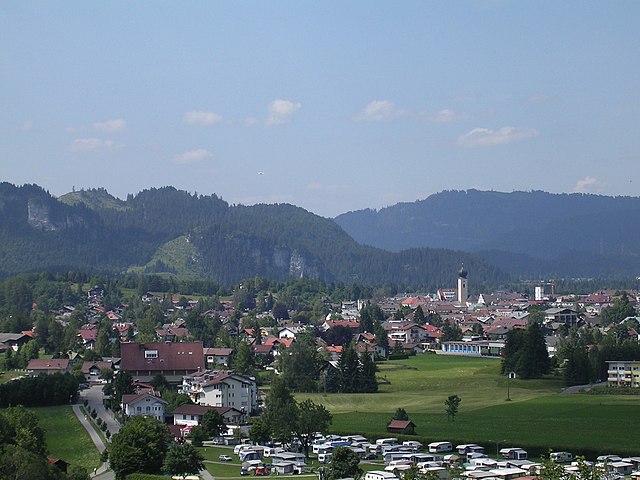
Гармиш-Партенкирхен
- город в Баварии
Hiking in Гармиш-Партенкирхен
Garmisch-Partenkirchen, located in the Bavarian Alps of Germany, is a fantastic destination for hiking enthusiasts. Renowned for its stunning alpine scenery, the area offers a variety of trails suitable for all skill levels, ranging from easy walks to challenging mountain hikes. Here are some highlights and tips for hiking in Garmisch-Partenkirchen:...
- Страна:
- Почтовый код: 82467
- Телефонный код: 08821
- Код автомобильного номера: GAP
- Координаты: 47° 30' 0" N, 11° 5' 0" E
- GPS треки (wikiloc): [Ссылка]
- Высота над уровнем моря: 708 м m
- Площадь: 205.66 кв.км
- Население: 26821
- Веб сайт: [Ссылка]


Миттенвальд
Hiking in Миттенвальд
Mittenwald, located in Bavaria, Germany, is a beautiful destination for hiking enthusiasts. Nestled in the Karwendel Mountain range, it offers a variety of trails that cater to all levels of hikers, from beginners to seasoned adventurers. Here are some highlights about hiking in the area:...
- Страна:
- Почтовый код: 82481
- Телефонный код: 08823
- Код автомобильного номера: GAP
- Координаты: 47° 25' 0" N, 11° 15' 0" E
- GPS треки (wikiloc): [Ссылка]
- Высота над уровнем моря: 923 м m
- Площадь: 132.85 кв.км
- Население: 7387
- Веб сайт: [Ссылка]


Эшенлоэ
Hiking in Эшенлоэ
Eschenlohe is a picturesque village in Bavaria, Germany, located near the Bavarian Alps. It's an excellent base for hiking enthusiasts looking to explore the beautiful landscapes that this region has to offer....
- Страна:
- Почтовый код: 82438
- Телефонный код: 08824
- Код автомобильного номера: GAP
- Координаты: 47° 36' 0" N, 11° 11' 0" E
- GPS треки (wikiloc): [Ссылка]
- Высота над уровнем моря: 640 м m
- Площадь: 55.05 кв.км
- Население: 1391
- Веб сайт: [Ссылка]


Грайнау
Hiking in Грайнау
Grainau is a picturesque village located at the foot of the Zugspitze, Germany's highest mountain. It offers a variety of hiking opportunities that cater to different skill levels, making it an excellent destination for both beginners and experienced hikers....
- Страна:
- Почтовый код: 82491
- Телефонный код: 08821
- Код автомобильного номера: GAP
- Координаты: 47° 28' 34" N, 11° 1' 29" E
- GPS треки (wikiloc): [Ссылка]
- Высота над уровнем моря: 758 м m
- Площадь: 49.38 кв.км
- Население: 3383
- Веб сайт: [Ссылка]


Мурнау-ам-Штаффельзее
Hiking in Мурнау-ам-Штаффельзее
Murnau am Staffelsee, located in Bavaria, Germany, is a beautiful area known for its picturesque landscapes, charming villages, and stunning lakes, making it a fantastic destination for hiking enthusiasts....
- Страна:
- Почтовый код: 82418
- Телефонный код: 08841
- Код автомобильного номера: GAP
- Координаты: 47° 41' 0" N, 11° 12' 0" E
- GPS треки (wikiloc): [Ссылка]
- Высота над уровнем моря: 688 м m
- Площадь: 38.05 кв.км
- Население: 12184
- Веб сайт: [Ссылка]

Уффинг-ам-Штаффельзее
Hiking in Уффинг-ам-Штаффельзее
Uffing is a charming village located in Bavaria, Germany, near the beautiful Ammersee Lake. The region is known for its stunning natural landscapes, making it a great destination for hiking enthusiasts. Here are some details about hiking in and around Uffing:...
- Страна:
- Почтовый код: 82449
- Телефонный код: 08846
- Код автомобильного номера: GAP
- Координаты: 47° 42' 50" N, 11° 9' 1" E
- GPS треки (wikiloc): [Ссылка]
- Высота над уровнем моря: 664 м m
- Площадь: 43.00 кв.км
- Население: 2194
- Веб сайт: [Ссылка]

Зеехаузен-ам-Штаффельзее
Hiking in Зеехаузен-ам-Штаффельзее
Seehausen am Staffelsee is a picturesque village located in Bavaria, Germany, near the stunning Staffelsee lake. The area is known for its beautiful landscapes, gentle hills, and rich natural beauty, making it an excellent destination for hiking enthusiasts. Here are some highlights and tips for hiking in and around Seehausen am Staffelsee:...
- Страна:
- Почтовый код: 82418
- Телефонный код: 08841
- Код автомобильного номера: GAP
- Координаты: 47° 41' 21" N, 11° 11' 6" E
- GPS треки (wikiloc): [Ссылка]
- Высота над уровнем моря: 658 м m
- Площадь: 15.71 кв.км
- Население: 2408
- Веб сайт: [Ссылка]


Бад-Кольгруб
Hiking in Бад-Кольгруб
Bad Kohlgrub, located in Bavaria, Germany, is a charming spa town nestled in the foothills of the Alps. It's a great destination for hiking enthusiasts seeking beautiful scenery, diverse trails, and a peaceful environment. Here are some key highlights and tips for hiking in Bad Kohlgrub:...
- Страна:
- Почтовый код: 82433
- Телефонный код: 08845
- Код автомобильного номера: GAP
- Координаты: 47° 40' 0" N, 11° 3' 0" E
- GPS треки (wikiloc): [Ссылка]
- Высота над уровнем моря: 828 м m
- Площадь: 32.66 кв.км
- Население: 2689
- Веб сайт: [Ссылка]


Ольштадт
Hiking in Ольштадт
Ohlstadt is a charming village located in Bavaria, Germany, surrounded by stunning natural landscapes that make it a great destination for hiking enthusiasts. Nestled at the foot of the Alps, Ohlstadt offers access to a variety of hiking trails suitable for all skill levels, from beginner walkers to experienced hikers....
- Страна:
- Почтовый код: 82441
- Телефонный код: 08841
- Код автомобильного номера: GAP
- Координаты: 47° 38' 0" N, 11° 14' 0" E
- GPS треки (wikiloc): [Ссылка]
- Высота над уровнем моря: 665 м m
- Площадь: 41.17 кв.км
- Население: 2609
- Веб сайт: [Ссылка]


Фархант
Hiking in Фархант
Farchant is a picturesque village located in Bavaria, Germany, near the edge of the Alps, making it an excellent starting point for hiking enthusiasts. The region is characterized by stunning landscapes, lush forests, and beautiful mountain scenery. Here are some highlights and tips for hiking in and around Farchant:...
- Страна:
- Почтовый код: 82490
- Телефонный код: 08821
- Код автомобильного номера: GAP
- Координаты: 47° 32' 0" N, 11° 7' 0" E
- GPS треки (wikiloc): [Ссылка]
- Высота над уровнем моря: 672 м m
- Площадь: 25.76 кв.км
- Население: 3220
- Веб сайт: [Ссылка]


Обераммергау
Hiking in Обераммергау
Oberammergau is a picturesque village located in Bavaria, Germany, nestled in the foothills of the Alps. Known for its stunning landscapes, rich culture, and the famous Passion Play, it also offers a plethora of hiking opportunities for enthusiasts of all levels. Here are some key points to consider when hiking in Oberammergau:...
- Страна:
- Почтовый код: 82487
- Телефонный код: 08822
- Код автомобильного номера: GAP
- Координаты: 47° 35' 48" N, 11° 3' 52" E
- GPS треки (wikiloc): [Ссылка]
- Высота над уровнем моря: 837 м m
- Площадь: 30.06 кв.км
- Население: 5458
- Веб сайт: [Ссылка]


Шпатценхаузен
Hiking in Шпатценхаузен
Spatzenhausen is a charming village located in Bavaria, Germany, and serves as a beautiful starting point for various hiking adventures in the surrounding area. Here are some key highlights of hiking in Spatzenhausen and its vicinity:...
- Страна:
- Почтовый код: 82447
- Телефонный код: 08847
- Код автомобильного номера: GAP
- Координаты: 47° 43' 0" N, 11° 12' 0" E
- GPS треки (wikiloc): [Ссылка]
- Высота над уровнем моря: 667 м m
- Площадь: 7.74 кв.км
- Население: 670
- Веб сайт: [Ссылка]


Унтераммергау
Hiking in Унтераммергау
Unterammergau is a charming village located in the Bavarian Alps of Germany, known for its picturesque landscapes and rich cultural heritage. It offers a wide range of hiking opportunities for all levels, from gentle strolls to more challenging trails. Below are some highlights of hiking in this beautiful region:...
- Страна:
- Почтовый код: 82497
- Телефонный код: 08822
- Код автомобильного номера: GAP
- Координаты: 47° 36' 0" N, 11° 2' 0" E
- GPS треки (wikiloc): [Ссылка]
- Высота над уровнем моря: 836 м m
- Площадь: 29.90 кв.км
- Население: 1217
- Веб сайт: [Ссылка]


Швайген
Hiking in Швайген
Hiking in Schwaigen, a picturesque region with a wealth of natural beauty, offers various trails catering to all levels of hikers. Though specific local details may vary, here's a general overview that can guide you:...
- Страна:
- Почтовый код: 82445
- Телефонный код: 08841
- Код автомобильного номера: GAP
- Координаты: 47° 37' 0" N, 11° 9' 0" E
- GPS треки (wikiloc): [Ссылка]
- Высота над уровнем моря: 656 м m
- Площадь: 23.58 кв.км
- Население: 556
- Веб сайт: [Ссылка]


Гросвайль
Hiking in Гросвайль
Großweil is a charming village located in Bavaria, Germany, surrounded by stunning landscapes and offering an array of hiking opportunities. Here are some key aspects to consider when hiking in this area:...
- Страна:
- Почтовый код: 82439
- Телефонный код: 08851
- Код автомобильного номера: GAP
- Координаты: 47° 41' 0" N, 11° 18' 0" E
- GPS треки (wikiloc): [Ссылка]
- Высота над уровнем моря: 621 м m
- Площадь: 22.04 кв.км
- Население: 1133
- Веб сайт: [Ссылка]


Бад-Байерзойен
Hiking in Бад-Байерзойен
Bad Bayersoien is a charming village located in the Bavarian Alps of Germany, known for its beautiful landscapes, refreshing lakes, and a range of hiking opportunities. The area offers a wonderful mix of scenic trails, from easy walks around the tranquil Soier See (Soier Lake) to more challenging hikes in the surrounding mountain ranges....
- Страна:
- Почтовый код: 82435
- Телефонный код: 08845
- Код автомобильного номера: GAP
- Координаты: 47° 41' 0" N, 11° 0' 0" E
- GPS треки (wikiloc): [Ссылка]
- Высота над уровнем моря: 812 м m
- Площадь: 17.65 кв.км
- Население: 1186
- Веб сайт: [Ссылка]


Заульгруб
Hiking in Заульгруб
Saulgrub, located in Bavaria, Germany, is a picturesque village situated in the beautiful Ammer Valley, surrounded by stunning natural landscapes, including the majestic Bavarian Alps. It's a great destination for hiking enthusiasts due to its varied terrain and numerous trails that cater to all skill levels. Here are some details about hiking in Saulgrub:...
- Страна:
- Почтовый код: 82442
- Телефонный код: 08845
- Код автомобильного номера: GAP
- Координаты: 47° 40' 0" N, 11° 2' 0" E
- GPS треки (wikiloc): [Ссылка]
- Высота над уровнем моря: 859 м m
- Площадь: 35.49 кв.км
- Население: 1469
- Веб сайт: [Ссылка]
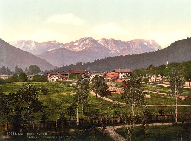

Оберау
Hiking in Оберау
Oberau, located in the picturesque Bavaria region of Germany, is an excellent destination for hiking enthusiasts. Nestled in the foothills of the Alps, it offers breathtaking landscapes, diverse trails, and a variety of outdoor activities. Here are some highlights and tips for hiking in Oberau:...
- Страна:
- Почтовый код: 82496
- Телефонный код: 08824
- Код автомобильного номера: GAP
- Координаты: 47° 33' 0" N, 11° 8' 0" E
- GPS треки (wikiloc): [Ссылка]
- Высота над уровнем моря: 659 м m
- Площадь: 17.86 кв.км
- Население: 2599
- Веб сайт: [Ссылка]


Этталь
Hiking in Этталь
Ettal, located in Bavaria, Germany, is a picturesque village nestled in the foothills of the Alps and is renowned for its stunning scenery, rich history, and proximity to various trails suitable for hiking enthusiasts of all levels. Here are some aspects to consider when hiking in the Ettal area:...
- Страна:
- Почтовый код: 82488
- Телефонный код: 08822
- Код автомобильного номера: GAP
- Координаты: 47° 34' 0" N, 11° 6' 0" E
- GPS треки (wikiloc): [Ссылка]
- Высота над уровнем моря: 897 м m
- Площадь: 140.75 кв.км
- Население: 911
- Веб сайт: [Ссылка]

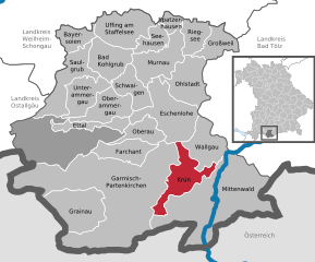
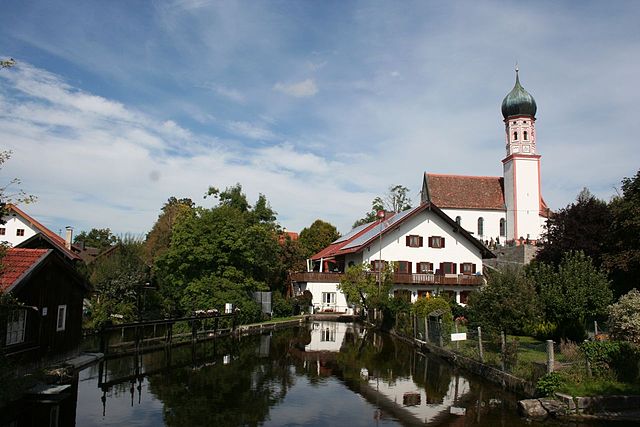
Крюн
Hiking in Крюн
Krün is a charming village located in Bavaria, Germany, surrounded by the stunning landscapes of the Alps. It serves as a fantastic base for hiking enthusiasts, offering a variety of trails that cater to different skill levels and preferences....
- Страна:
- Почтовый код: 82493; 82467; 82494
- Телефонный код: 08825
- Код автомобильного номера: GAP
- Координаты: 47° 30' 0" N, 11° 17' 0" E
- GPS треки (wikiloc): [Ссылка]
- Высота над уровнем моря: 875 м m
- Площадь: 36.31 кв.км
- Население: 1745
- Веб сайт: [Ссылка]


Ригзее
Hiking in Ригзее
Riegsee, located in Bavaria, Germany, is a picturesque area known for its natural beauty, making it a great destination for hiking enthusiasts. The lake itself offers stunning views and a tranquil setting, while the surrounding landscapes feature rolling hills and dense forests. Here are some aspects to consider when hiking in the Riegsee area:...
- Страна:
- Почтовый код: 82418
- Телефонный код: 08841
- Код автомобильного номера: GAP
- Координаты: 47° 42' 0" N, 11° 14' 0" E
- GPS треки (wikiloc): [Ссылка]
- Высота над уровнем моря: 668 м m
- Площадь: 20.44 кв.км
- Население: 1000
- Веб сайт: [Ссылка]


Вальгау
Hiking in Вальгау
Wallgau is a charming village located in the Bavarian Alps of Germany, nestled at the edge of the Karwendel mountain range and close to the pristine shores of the Walchensee lake. It’s an excellent spot for hiking enthusiasts, offering a variety of trails that cater to different skill levels. Here’s an overview of what to expect when hiking in and around Wallgau:...
- Страна:
- Почтовый код: 82499
- Телефонный код: 08825
- Код автомобильного номера: GAP
- Координаты: 47° 31' 0" N, 11° 17' 0" E
- GPS треки (wikiloc): [Ссылка]
- Высота над уровнем моря: 866 м m
- Площадь: 33.96 кв.км
- Население: 1170
- Веб сайт: [Ссылка]
Граничит с регионами:

Восточный Альгой
- Район в Германии. Центр района — город Марктобердорф.
Hiking in Восточный Альгой
Ostallgäu is a picturesque region in Bavaria, Germany, known for its stunning landscapes dominated by the Alps, rolling hills, and charming villages. It's an excellent destination for hiking, offering a variety of trails suitable for different skill levels, from beginner to advanced. Here are some key highlights of hiking in Ostallgäu:...
- Страна:
- Столица: Марктобердорф
- Код автомобильного номера: OAL; MOD; FÜS
- Координаты: 47° 45' 0" N, 10° 34' 48" E
- GPS треки (wikiloc): [Ссылка]
- Высота над уровнем моря: 724 м m
- Площадь: 1395.00 кв.км
- Население: 114547
- Веб сайт: [Ссылка]

Вайльхайм-Шонгау
- район Баварии
Hiking in Вайльхайм-Шонгау
Weilheim-Schongau, located in Bavaria, Germany, is a fantastic area for hiking enthusiasts. The region is characterized by its stunning landscapes, which include rolling hills, lush forests, and the picturesque foothills of the Alps. Here are some highlights and recommendations for hiking in this beautiful region:...
- Страна:
- Столица: Вайльхайм
- Код автомобильного номера: SOG; WM
- Координаты: 47° 49' 48" N, 11° 0' 0" E
- GPS треки (wikiloc): [Ссылка]
- Высота над уровнем моря: 647 м m
- Площадь: 966.22 кв.км
- Население: 106376
- Веб сайт: [Ссылка]

Бад-Тёльц-Вольфратсхаузен
- район Баварии
Hiking in Бад-Тёльц-Вольфратсхаузен
Bad Tölz-Wolfratshausen is a picturesque region in Bavaria, Germany, known for its stunning landscapes and excellent hiking opportunities. Nestled in the foothills of the Alps, this area offers a variety of trails that cater to different skill levels, from gentle walks suitable for families to more challenging hikes for experienced adventurers....
- Страна:
- Столица: Бад-Тёльц
- Код автомобильного номера: WOR; TÖL
- Координаты: 47° 45' 0" N, 11° 34' 48" E
- GPS треки (wikiloc): [Ссылка]
- Высота над уровнем моря: 848 м m
- Площадь: 1111.00 кв.км
- Население: 126572
- Веб сайт: [Ссылка]


Швац
Hiking in Швац
Hiking in the Schwaz District, located in Tyrol, Austria, offers stunning landscapes, varied terrain, and a rich cultural experience. The area is surrounded by the impressive mountain ranges of the Alps, making it a fantastic location for both casual hikers and experienced trekkers....
- Страна:

- Столица: Швац
- Код автомобильного номера: SZ
- Координаты: 47° 24' 0" N, 11° 48' 0" E
- GPS треки (wikiloc): [Ссылка]
- Высота над уровнем моря: 1676 м m
- Площадь: 1843 кв.км
- Население: 81841
- Веб сайт: [Ссылка]


Имст
Hiking in Имст
The Imst District, located in the Tyrol region of Austria, is a fantastic destination for hiking enthusiasts. Known for its stunning Alpine landscapes, varied terrain, and charming villages, the area offers a wide range of hiking trails suitable for all skill levels, from beginner to advanced climbers....
- Страна:
- Столица: Имст
- Код автомобильного номера: IM
- Координаты: 47° 6' 0" N, 10° 54' 0" E
- GPS треки (wikiloc): [Ссылка]
- Высота над уровнем моря: 2627 м m
- Площадь: 1724.82 кв.км
- Население: 58214
- Веб сайт: [Ссылка]


Инсбрук
Hiking in Инсбрук
Innsbruck-Land District, located in the Tyrol region of Austria, offers a remarkable hiking experience due to its stunning landscapes, diverse terrain, and a variety of trails suitable for all skill levels. Here are some highlights and tips for hiking in this picturesque area:...
- Страна:
- Столица: Инсбрук
- Код автомобильного номера: IL
- Координаты: 47° 12' 0" N, 11° 24' 0" E
- GPS треки (wikiloc): [Ссылка]
- Высота над уровнем моря: 1931 м m
- Площадь: 1990.09 кв.км
- Веб сайт: [Ссылка]
Ройтте (округ)
Hiking in Ройтте (округ)
The Reutte District, located in the Tyrol region of Austria, is known for its stunning natural landscapes, charming villages, and a variety of hiking trails suitable for all levels of hikers. Here are some key aspects of hiking in this area:...
- Страна:
- Столица: Ройтте
- Код автомобильного номера: RE
- Координаты: 47° 24' 0" N, 10° 30' 0" E
- GPS треки (wikiloc): [Ссылка]
- Высота над уровнем моря: 1222 м m
- Площадь: 1236.82 кв.км
- Население: 32023
- Веб сайт: [Ссылка]