Ревест-Сен-Мартен (Revest-Saint-Martin, Revest-Saint-Martin)
- коммуна во Франции
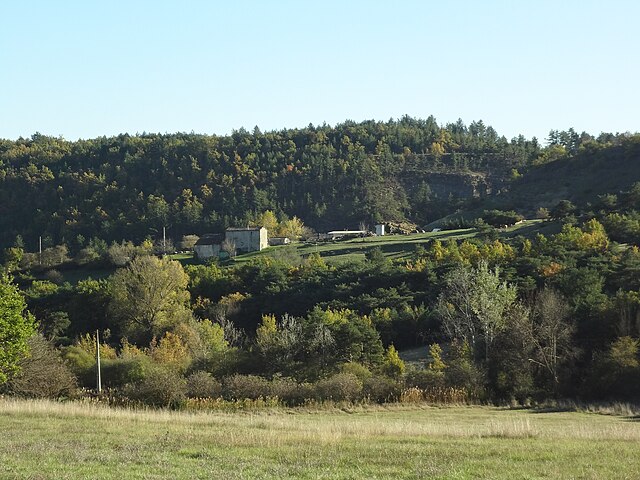
 Hiking in Ревест-Сен-Мартен
Revest-Saint-Martin, located in the Provence-Alpes-Côte d'Azur region of southeastern France, offers beautiful hiking opportunities amid stunning natural landscapes. The area is characterized by its diverse topography, including hills, forests, and panoramic views of the surrounding mountains and valleys.
Key Highlights for Hiking in Revest-Saint-Martin:
-
Scenic Trails: The region boasts a variety of hiking trails suitable for all levels, from easy walks to more challenging hikes. Some paths provide access to breathtaking vistas of the Var region.
-
Natural Beauty: As you hike, you can enjoy the diverse flora and fauna typical of the Mediterranean climate. Be sure to keep an eye out for local wildlife and unique plant species.
-
Historical Sites: Along the hiking trails, you may encounter historical landmarks, such as ruins or old village structures, which add an interesting cultural aspect to your hiking experience.
-
Connection to Nature: Many trails wind through natural spaces that allow for a deeper connection to the environment. The peaceful surroundings are perfect for meditation and relaxation.
-
Recommended Routes:
- The Sentier des Mésanges: A well-marked trail that offers a moderate challenge, ideal for families and nature lovers.
- Pic de La Colle: A more challenging hike that rewards you with stunning panoramic views from the summit.
-
Safety and Preparation: As with any hiking experience, it's essential to prepare adequately. Check the weather conditions, wear appropriate clothing and footwear, and carry enough water and snacks. The trails can vary in difficulty, so choose routes that match your experience level.
-
Local Advice: Consider visiting local information centers for maps and guidance on the best trails. Local hikers can offer valuable insights into current trail conditions and hidden gems.
Best Time to Hike:
The ideal times for hiking in Revest-Saint-Martin are in the spring (April to June) and autumn (September to October) when the weather is mild, and the landscapes are often vibrant with colors.
Overall, hiking in Revest-Saint-Martin is a rewarding experience that combines the beauty of nature with cultural exploration.
- Страна:

- Почтовый код: 04230
- Координаты: 44° 0' 41" N, 5° 49' 36" E


- GPS треки (wikiloc): [Ссылка]
- Площадь: 7.56 кв.км
- Население: 69
- Википедия русская: wiki(ru)
- Википедия английская: wiki(en)
- Википедия национальная: wiki(fr)
- Хранилище Wikidata: Wikidata: Q1017909
- Катеория в википедии: [Ссылка]
- код Freebase: [/m/03m7x8c]
- код Freebase: [/m/03m7x8c]
- код GeoNames: Альт: [2983816]
- код GeoNames: Альт: [2983816]
- номер SIREN: [210401642]
- номер SIREN: [210401642]
- код муниципалитета INSEE: 04164
- код муниципалитета INSEE: 04164
Граничит с регионами:

Сент-Этьен-лез-Орг
- коммуна во Франции
Hiking in Сент-Этьен-лез-Орг
Saint-Étienne-les-Orgues is a picturesque village located in the Alpes-de-Haute-Provence region of southern France. It lies in a beautiful natural setting, surrounded by diverse landscapes, which makes it a great destination for hiking enthusiasts. Here are some key points about hiking in this area:...
- Страна:
- Почтовый код: 04230
- Координаты: 44° 2' 46" N, 5° 46' 49" E
- GPS треки (wikiloc): [Ссылка]
- Площадь: 48.42 кв.км
- Население: 1249
- Веб сайт: [Ссылка]

Сигонс
- коммуна во Франции
Hiking in Сигонс
Sigonce, a picturesque village located in the Provence-Alpes-Côte d'Azur region of France, is a hidden gem for outdoor enthusiasts. The surrounding landscape features rolling hills, dense forests, and stunning views that make it an ideal destination for hiking. Here are some highlights and tips for hiking in Sigonce:...
- Страна:
- Почтовый код: 04300
- Координаты: 43° 59' 49" N, 5° 50' 25" E
- GPS треки (wikiloc): [Ссылка]
- Площадь: 19.97 кв.км
- Население: 429
Монло
- коммуна во Франции
Hiking in Монло
Montlaux is a charming destination for hiking enthusiasts, located in the Provence-Alpes-Côte d'Azur region of France. Nestled in the picturesque Verdon region, it offers a variety of trails that cater to different levels of hikers, from beginners to experienced trekkers....
- Страна:
- Почтовый код: 04230
- Координаты: 44° 2' 49" N, 5° 50' 40" E
- GPS треки (wikiloc): [Ссылка]
- Высота над уровнем моря: 550 м m
- Площадь: 19.75 кв.км
- Население: 143

Фонтьен
- коммуна во Франции
Hiking in Фонтьен
Fontienne is not a widely known hiking destination, so it's possible that you're referring to a specific area or a local trail that has not gained significant recognition outside its immediate region. Here are some general guidelines and tips for hiking in lesser-known areas that may apply to hiking in Fontienne or similar locations:...
- Страна:
- Почтовый код: 04230
- Координаты: 44° 0' 32" N, 5° 47' 36" E
- GPS треки (wikiloc): [Ссылка]
- Площадь: 8.18 кв.км
- Население: 129