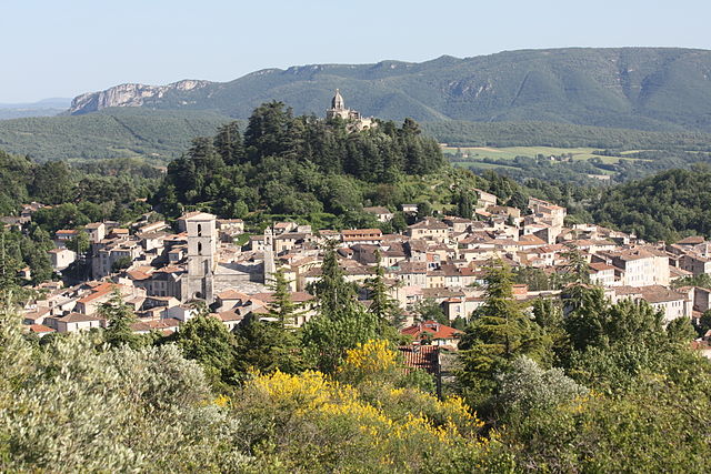
Сигонс (Sigonce, Sigonce)
- коммуна во Франции
 Hiking in Сигонс
Sigonce, a picturesque village located in the Provence-Alpes-Côte d'Azur region of France, is a hidden gem for outdoor enthusiasts. The surrounding landscape features rolling hills, dense forests, and stunning views that make it an ideal destination for hiking. Here are some highlights and tips for hiking in Sigonce:
Hiking Trails
-
Local Trails: The area around Sigonce offers a variety of trails, ranging from easy walks suitable for families to more challenging hikes for experienced adventurers. Look for local signposts and maps that guide you through stunning natural landscapes.
-
Cistercian Monastery Trails: Nearby, you can hike trails that lead to historical sites, including ancient monasteries and charming rural farms. These routes often provide a combination of natural beauty and cultural heritage.
-
The Luberon Regional Nature Park: Just a short drive from Sigonce, this protected area offers an extensive network of trails. You can experience diverse ecosystems, breathtaking vistas, and the chance to spot wildlife.
Best Times to Hike
- Spring and Fall: These seasons are particularly lovely, as temperatures are mild, and the flora is vibrant. Ideal for both leisurely hikes and more strenuous endeavors.
- Summer: It can be quite warm, so early morning or late afternoon hikes are best to avoid the heat.
Preparation Tips
- Footwear: Wear sturdy hiking boots for stability and comfort on uneven terrain.
- Hydration: Always carry enough water, especially during warmer months.
- Navigation: Consider bringing a map or using a GPS app to help you navigate the trails.
- Local Regulations: Check for any local regulations or guidelines concerning trail use, wildlife, and safety.
Other Activities
In addition to hiking, Sigonce and its surroundings offer opportunities for cycling, exploring nearby villages, and enjoying local cuisine. Don’t forget to take in the tranquil beauty of the countryside, and perhaps visit a local market or café.
Conclusion
Hiking in Sigonce is a rewarding experience, combining beautiful landscapes, cultural insights, and a chance to immerse yourself in nature. Whether you are a beginner or a seasoned hiker, you will find trails that will suit your interests and skills. Make sure to plan ahead and take full advantage of the stunning environment!
- Страна:

- Почтовый код: 04300
- Координаты: 43° 59' 49" N, 5° 50' 25" E


- GPS треки (wikiloc): [Ссылка]
- Площадь: 19.97 кв.км
- Население: 429
- Википедия русская: wiki(ru)
- Википедия английская: wiki(en)
- Википедия национальная: wiki(fr)
- Хранилище Wikidata: Wikidata: Q1112920
- Катеория в википедии: [Ссылка]
- код Freebase: [/m/03m7xnd]
- код Freebase: [/m/03m7xnd]
- код GeoNames: Альт: [2974574]
- код GeoNames: Альт: [2974574]
- номер SIREN: [210402061]
- номер SIREN: [210402061]
- код VIAF: Альт: [130346645]
- код VIAF: Альт: [130346645]
- код LCNAF: Альт: [n95086867]
- код LCNAF: Альт: [n95086867]
- код муниципалитета INSEE: 04206
- код муниципалитета INSEE: 04206
Граничит с регионами:

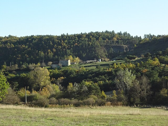
Ревест-Сен-Мартен
- коммуна во Франции
Hiking in Ревест-Сен-Мартен
Revest-Saint-Martin, located in the Provence-Alpes-Côte d'Azur region of southeastern France, offers beautiful hiking opportunities amid stunning natural landscapes. The area is characterized by its diverse topography, including hills, forests, and panoramic views of the surrounding mountains and valleys....
- Страна:
- Почтовый код: 04230
- Координаты: 44° 0' 41" N, 5° 49' 36" E
- GPS треки (wikiloc): [Ссылка]
- Площадь: 7.56 кв.км
- Население: 69

Люр
- коммуна во Франции
Hiking in Люр
Lurs, located in the Alpes-de-Haute-Provence region of France, offers a unique and picturesque setting for hiking enthusiasts. This charming village is perched on a hill and is surrounded by beautiful landscapes, including rolling hills, olive groves, and views of the lavender fields that the region is famous for....
- Страна:
- Почтовый код: 04700
- Координаты: 43° 58' 10" N, 5° 53' 21" E
- GPS треки (wikiloc): [Ссылка]
- Площадь: 22.48 кв.км
- Население: 377

Ганагоби
- коммуна во Франции
Hiking in Ганагоби
Ganagobie is a beautiful region located in the Alpes-de-Haute-Provence department of southeastern France. It is known for its stunning landscapes, rich biodiversity, and the historic Saint-Marie de Ganagobie Monastery, which sits on a hill overlooking the countryside. Here are some highlights about hiking in Ganagobie:...
- Страна:
- Почтовый код: 04310
- Координаты: 44° 0' 32" N, 5° 54' 59" E
- GPS треки (wikiloc): [Ссылка]
- Площадь: 10.5 кв.км
- Население: 85
Форкалькье
- коммуна во Франции
Hiking in Форкалькье
Forcalquier is a charming town located in the Alpes-de-Haute-Provence region of southeastern France. It is surrounded by stunning natural landscapes, making it a great destination for hiking enthusiasts....
- Страна:
- Почтовый код: 04300
- Координаты: 43° 57' 33" N, 5° 46' 47" E
- GPS треки (wikiloc): [Ссылка]
- Площадь: 42.76 кв.км
- Население: 4981
- Веб сайт: [Ссылка]

Пьеррю
- коммуна во Франции
Hiking in Пьеррю
Pierrerue, located in the Alpes-de-Haute-Provence region of southeastern France, offers a wonderful natural setting for hiking enthusiasts. The area is characterized by stunning landscapes, rolling hills, and a unique blend of Mediterranean and alpine flora. Here are some highlights and tips for hiking in and around Pierrerue:...
- Страна:
- Почтовый код: 04300
- Координаты: 43° 57' 22" N, 5° 49' 58" E
- GPS треки (wikiloc): [Ссылка]
- Площадь: 10.86 кв.км
- Население: 488
- Веб сайт: [Ссылка]

Пейрюи
- коммуна во Франции
Hiking in Пейрюи
Peyruis, located in the Alpes-de-Haute-Provence region of France, offers some charming hiking opportunities that attract nature enthusiasts. The area is characterized by its picturesque landscapes, rolling hills, and scenic views of the surrounding alpine environment. Here are some key points to consider when hiking in and around Peyruis:...
- Страна:
- Почтовый код: 04310
- Координаты: 44° 1' 44" N, 5° 56' 25" E
- GPS треки (wikiloc): [Ссылка]
- Площадь: 23.23 кв.км
- Население: 2849
Монло
- коммуна во Франции
Hiking in Монло
Montlaux is a charming destination for hiking enthusiasts, located in the Provence-Alpes-Côte d'Azur region of France. Nestled in the picturesque Verdon region, it offers a variety of trails that cater to different levels of hikers, from beginners to experienced trekkers....
- Страна:
- Почтовый код: 04230
- Координаты: 44° 2' 49" N, 5° 50' 40" E
- GPS треки (wikiloc): [Ссылка]
- Высота над уровнем моря: 550 м m
- Площадь: 19.75 кв.км
- Население: 143

Фонтьен
- коммуна во Франции
Hiking in Фонтьен
Fontienne is not a widely known hiking destination, so it's possible that you're referring to a specific area or a local trail that has not gained significant recognition outside its immediate region. Here are some general guidelines and tips for hiking in lesser-known areas that may apply to hiking in Fontienne or similar locations:...
- Страна:
- Почтовый код: 04230
- Координаты: 44° 0' 32" N, 5° 47' 36" E
- GPS треки (wikiloc): [Ссылка]
- Площадь: 8.18 кв.км
- Население: 129