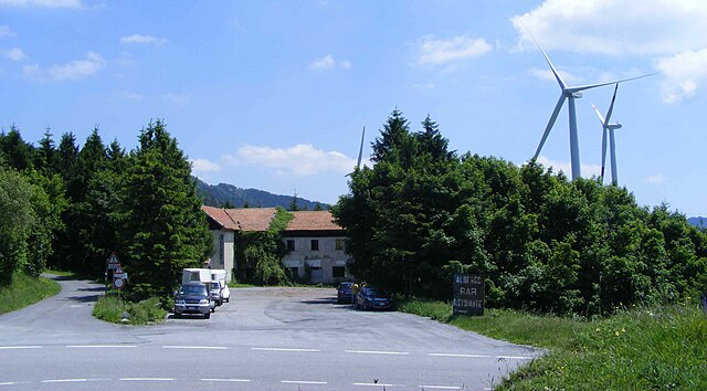
Робурент (Roburent, Roburent)
- коммуна Италии
 Hiking in Робурент
Roburent is a charming mountain village located in the Piedmont region of Italy, nestled in the Cuneo province. This area is part of the Maritime Alps and offers a variety of hiking opportunities that cater to different skill levels. Here are some key points about hiking in and around Roburent:
Trails and Routes
-
Scenic Trails: Roburent is surrounded by beautiful landscapes, including lush forests, alpine meadows, and impressive mountain views. Trails typically lead through picturesque valleys and offer a chance to experience the region's diverse flora and fauna.
-
Difficulty Levels: Hikes range from easy, family-friendly paths to more challenging routes suitable for experienced hikers. Look for trails marked with signs, or consider getting a local map for detailed information.
-
Popular Hikes:
- Bric Mindino: A moderate hike that rewards you with stunning panoramic views of the surrounding mountains and valleys.
- Colle della Rossa: A more challenging hike that offers a good workout along with breathtaking vistas.
Best Time to Hike
- Spring and Fall: These seasons offer milder weather and are ideal for hiking. Spring features blooming wildflowers, while fall showcases vibrant autumn colors.
- Summer: While summer can be a popular time for hiking, be prepared for warmer temperatures. Early morning hikes can help you avoid the heat.
Essential Tips
- Prepare Properly: Wear sturdy hiking boots and dress in layers. Weather can change quickly in the mountains, so be ready for varying conditions.
- Stay Hydrated: Carry enough water, especially on longer hikes, and be mindful of your energy levels.
- Respect Nature: Follow local guidelines for Leave No Trace principles to protect the beautiful environment.
Local Amenities
- Accommodations: Roburent has various accommodation options, from hotels to guesthouses, making it convenient for multi-day hiking trips.
- Guided Tours: If you're unfamiliar with the area, consider joining a guided hike. Local guides can offer insights into the terrain, wildlife, and history.
Overall, Roburent offers a fantastic hiking experience, combining natural beauty, well-marked trails, and a slice of Italian mountain culture. Enjoy your hike!
- Страна:

- Почтовый код: 12080
- Телефонный код: 0174
- Код автомобильного номера: CN
- Координаты: 44° 19' 0" N, 7° 53' 0" E


- GPS треки (wikiloc): [Ссылка]
- Высота над уровнем моря: 788 м m
- Площадь: 29.81 кв.км
- Население: 496
- Веб сайт: http://www.comune.roburent.cn.it/index.html
- Википедия русская: wiki(ru)
- Википедия английская: wiki(en)
- Википедия национальная: wiki(it)
- Хранилище Wikidata: Wikidata: Q20408
- Катеория в википедии: [Ссылка]
- код Freebase: [/m/0gbcsh]
- код GeoNames: Альт: [6543464]
- код VIAF: Альт: [234402957]
- ID отношения в OpenStreetMap: [42951]
- код ISTAT: 004186
- кадастровый код Италии: H378
Граничит с регионами:
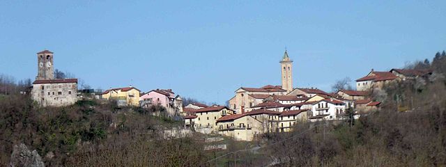
Фрабоза-Сопрана
- коммуна Италии
Hiking in Фрабоза-Сопрана
Frabosa Soprana is a charming village located in the Piedmont region of Italy, nestled within the Maritime Alps. It's known for its stunning natural landscapes, and it serves as an excellent gateway for hiking enthusiasts. Here are some highlights and recommendations for hiking in and around Frabosa Soprana:...
- Страна:
- Почтовый код: 12082
- Телефонный код: 0174
- Код автомобильного номера: CN
- Координаты: 44° 17' 14" N, 7° 48' 25" E
- GPS треки (wikiloc): [Ссылка]
- Высота над уровнем моря: 891 м m
- Площадь: 47.14 кв.км
- Население: 754
- Веб сайт: [Ссылка]
Гарессио
- коммуна Италии
Hiking in Гарессио
Garessio, located in the Piedmont region of northern Italy, offers a beautiful setting for hiking enthusiasts. Nestled in the Ligurian Alps, it is surrounded by stunning landscapes, diverse flora and fauna, and picturesque views. Here are some highlights about hiking in Garessio:...
- Страна:
- Почтовый код: 12075
- Телефонный код: 0174
- Код автомобильного номера: CN
- Координаты: 44° 12' 0" N, 8° 1' 0" E
- GPS треки (wikiloc): [Ссылка]
- Высота над уровнем моря: 621 м m
- Площадь: 131.29 кв.км
- Население: 3132
- Веб сайт: [Ссылка]

Монтальдо-ди-Мондови
- коммуна Италии
Hiking in Монтальдо-ди-Мондови
Montaldo di Mondovì is a charming town located in the Piedmont region of Italy, surrounded by beautiful landscapes that are perfect for hiking enthusiasts. The area offers a variety of trails that cater to different skill levels, making it an excellent destination for both novice hikers and experienced trekkers....
- Страна:
- Почтовый код: 12080
- Телефонный код: 0174
- Код автомобильного номера: CN
- Координаты: 44° 19' 0" N, 7° 52' 0" E
- GPS треки (wikiloc): [Ссылка]
- Высота над уровнем моря: 800 м m
- Площадь: 23.58 кв.км
- Население: 562
- Веб сайт: [Ссылка]

Ормеа
- коммуна Италии
Hiking in Ормеа
Ormea, located in the Liguria region of Italy, is a hidden gem for hiking enthusiasts. Nestled in the Maritime Alps, this charming town offers breathtaking landscapes, rich biodiversity, and a variety of trails suitable for all experience levels. Here are some key points about hiking in and around Ormea:...
- Страна:
- Почтовый код: 12078
- Телефонный код: 0174
- Код автомобильного номера: CN
- Координаты: 44° 9' 0" N, 7° 55' 0" E
- GPS треки (wikiloc): [Ссылка]
- Высота над уровнем моря: 740 м m
- Площадь: 124.5 кв.км
- Население: 1607
- Веб сайт: [Ссылка]

Пампарато
- Коммуна в Италии, располагается в регионе Пьемонт, подчиняется административному центру Кунео.
Hiking in Пампарато
Pamparato is a picturesque town located in the Piedmont region of Italy, specifically in the province of Cuneo. It is nestled in the Maritime Alps, making it an excellent destination for hiking enthusiasts. Here are some highlights and tips for hiking in the Pamparato area:...
- Страна:
- Почтовый код: 12087
- Телефонный код: 0174
- Код автомобильного номера: CN
- Координаты: 44° 17' 0" N, 7° 55' 0" E
- GPS треки (wikiloc): [Ссылка]
- Высота над уровнем моря: 816 м m
- Площадь: 34.51 кв.км
- Население: 298
- Веб сайт: [Ссылка]
Торре-Мондови
- коммуна Италии
Hiking in Торре-Мондови
Torre Mondovì is a charming town located in the Piedmont region of Italy, nestled in the foothills of the Alps. The area is known for its beautiful landscapes, rich history, and a network of hiking trails that cater to various skill levels....
- Страна:
- Почтовый код: 12080
- Телефонный код: 0174
- Код автомобильного номера: CN
- Координаты: 44° 21' 0" N, 7° 54' 0" E
- GPS треки (wikiloc): [Ссылка]
- Высота над уровнем моря: 460 м m
- Площадь: 18.54 кв.км
- Население: 487
- Веб сайт: [Ссылка]