Ротентурм (Rothenthurm, Rothenthurm SZ)

- коммуна в Швейцарии
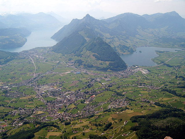
 Hiking in Ротентурм
Rothenthurm, located in the Canton of Schwyz in Switzerland, is a beautiful area for hiking, renowned for its stunning landscapes, diverse flora and fauna, and panoramic views of the Swiss Alps. Here are some highlights and tips for hiking in Rothenthurm:
Key Hiking Trails:
-
Rothenthurm to Ägerisee: This hike offers a picturesque route from Rothenthurm down to Lake Ägerisee. The trail provides beautiful views of the lake and surrounding mountains.
-
Höhenweg Rothenthurm: A scenic high-altitude path that showcases the impressive Toggenburg mountain range. This trail is often well-marked and suitable for moderate hikers.
-
Nature Trail: There are marked nature trails in the area that provide insights into local wildlife and plants, perfect for families and those interested in the natural environment.
Difficulty Levels:
- Trails range from easy to moderate, making it suitable for hikers of all skill levels. Always check the trail ratings and conditions before heading out.
Best Time to Hike:
- Spring (April to June): Wildflowers bloom, and the landscape comes to life.
- Summer (July to August): Warm temperatures and long days are ideal for multiple hiking adventures.
- Autumn (September to October): The fall foliage creates stunning scenery, perfect for photography.
- Winter hikes are also available, especially in snow-covered areas, but be mindful of conditions and avalanche risks.
Preparation Tips:
- Gear: Wear proper hiking boots and pack layers, as weather can change rapidly in the mountains.
- Navigation: Use local maps and GPS devices. Some trails might not be well marked.
- Refreshments: Bring water and snacks. While there are sometimes mountain huts, it’s important to be self-sufficient on longer hikes.
- Safety: Always inform someone about your hiking plans and estimated return time.
Wildlife and Nature:
Rothenthurm is home to diverse wildlife, including chamois and various bird species. Keep an eye out for local plant species and enjoy the unique Alpine ecosystem.
Community and Events:
Check for local hiking events or guided tours that may be available in the Rothenthurm area, which can enhance your experience and offer deeper insights into the local environment.
Whether you're looking for a peaceful escape in nature or an adventure through the mountainous terrain, Rothenthurm provides a perfect setting for your hiking endeavors. Enjoy your hike!
- Страна:

- Почтовый код: 6418
- Телефонный код: 041
- Код автомобильного номера: SZ
- Координаты: 47° 6' 15" N, 8° 40' 28" E


- GPS треки (wikiloc): [Ссылка]
- Высота над уровнем моря: 925 м m
- Площадь: 22.80 кв.км
- Население: 2395
- Веб сайт: http://www.rothenthurm.ch
- Википедия русская: wiki(ru)
- Википедия английская: wiki(en)
- Википедия национальная: wiki(de)
- Хранилище Wikidata: Wikidata: Q66962
- Катеория в википедии: [Ссылка]
- код Freebase: [/m/0fw54q]
- код GeoNames: Альт: [7286961]
- код VIAF: Альт: [246958758]
- ID отношения в OpenStreetMap: [1683098]
- код GND: Альт: [4565260-0]
- идентификатор местоположения ArchINFORM: [10523]
- идентификатор HDS: [734]
- код швейцарского муниципалитета: [1370]
Граничит с регионами:

Оберегери
- коммуна в Швейцарии
Hiking in Оберегери
Oberägeri, located in the Canton of Zug in Switzerland, is a beautiful destination for hiking enthusiasts. Nestled between the Ägeri lake and the surrounding hills, it offers a variety of trails that cater to different skill levels and provide stunning views of the Swiss landscape....
- Страна:
- Почтовый код: 6315
- Телефонный код: 041
- Код автомобильного номера: ZG
- Координаты: 47° 8' 9" N, 8° 36' 49" E
- GPS треки (wikiloc): [Ссылка]
- Высота над уровнем моря: 737 м m
- Площадь: 36.2 кв.км
- Население: 6059
- Веб сайт: [Ссылка]


Заттель
- коммуна в Швейцарии
Hiking in Заттель
Sattel, located in the canton of Schwyz, is a beautiful hiking destination in Switzerland, known for its stunning landscapes and a range of outdoor activities. Situated between Lake Zug and Lake Lauerz, Sattel offers breathtaking views of the surrounding mountains and valleys....
- Страна:
- Почтовый код: 6417
- Телефонный код: 041
- Код автомобильного номера: SZ
- Координаты: 47° 4' 48" N, 8° 37' 55" E
- GPS треки (wikiloc): [Ссылка]
- Высота над уровнем моря: 780 м m
- Площадь: 17.3 кв.км
- Население: 1946
- Веб сайт: [Ссылка]


Альпталь
Hiking in Альпталь
Alpthal, located in the picturesque Canton of Schwyz in Switzerland, is a fantastic destination for hiking enthusiasts. Nestled in the Alps, it offers stunning views, diverse trails, and the opportunity to experience the natural beauty of the Swiss landscape....
- Страна:
- Почтовый код: 8849
- Телефонный код: 055
- Код автомобильного номера: SZ
- Координаты: 47° 3' 28" N, 8° 42' 51" E
- GPS треки (wikiloc): [Ссылка]
- Высота над уровнем моря: 1064 м m
- Площадь: 22.90 кв.км
- Население: 613
- Веб сайт: [Ссылка]

Швиц
- город в Швейцарии, столица кантона Швиц
Hiking in Швиц
Hiking in Schwyz, located in central Switzerland, offers stunning landscapes, rich history, and a variety of trails catering to different skill levels. Here are some highlights and tips for hiking in this beautiful region:...
- Страна:
- Почтовый код: 6430
- Телефонный код: 041
- Код автомобильного номера: SZ
- Координаты: 47° 1' 14" N, 8° 39' 30" E
- GPS треки (wikiloc): [Ссылка]
- Высота над уровнем моря: 852 м m
- Площадь: 53.28 кв.км
- Население: 15000
- Веб сайт: [Ссылка]


Айнзидельн
- коммуна в Швейцарии
Hiking in Айнзидельн
Einsiedeln, located in the Canton of Schwyz in Switzerland, is a beautiful destination for hiking enthusiasts. Nestled in the picturesque alpine landscape, it offers a variety of trails suitable for all levels, from leisurely strolls to more challenging hikes....
- Страна:
- Почтовый код: 8840
- Телефонный код: 055
- Код автомобильного номера: SZ
- Координаты: 47° 7' 40" N, 8° 44' 35" E
- GPS треки (wikiloc): [Ссылка]
- Высота над уровнем моря: 882 м m
- Площадь: 110.40 кв.км
- Население: 15550
- Веб сайт: [Ссылка]