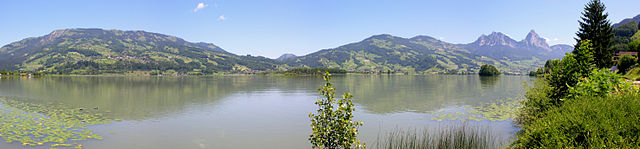
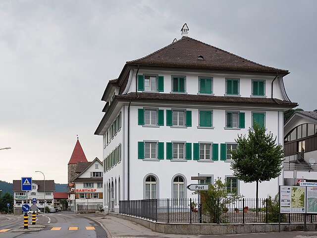
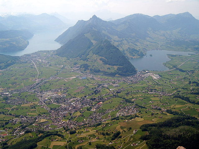
Заттель (Sattel, Sattel)

- коммуна в Швейцарии
 Hiking in Заттель
Sattel, located in the canton of Schwyz, is a beautiful hiking destination in Switzerland, known for its stunning landscapes and a range of outdoor activities. Situated between Lake Zug and Lake Lauerz, Sattel offers breathtaking views of the surrounding mountains and valleys.
Hiking Trails
Sattel features various well-marked hiking trails that cater to different skill levels, from easy walks to challenging hikes. Some popular trails include:
-
Sattel-Mouton: A scenic and relatively easy hike that allows you to enjoy the picturesque views of the nearby mountains and lakes. This trail is ideal for families and offers beautiful panoramic views.
-
Brunni Trail: A more challenging hike that takes you up to the Brunni area, offering more technical terrain and rewarding vistas. The trail often leads through lush forests and past charming alpine meadows.
-
Chärnelen Trail: This trail offers a moderate hike with various viewpoints along the way, perfect for those who want to experience the tranquility of the Swiss landscape.
Hiking Tips
- Preparation: Always check the weather conditions before heading out, especially in mountainous areas where the weather can change rapidly.
- Footwear: Wear sturdy hiking boots with good grip to navigate the varied terrain safely.
- Water and Snacks: Bring plenty of water and energy-boosting snacks, especially for longer hikes.
- Map and Navigation: While trails are well-marked, it's good to carry a detailed map or a GPS device.
Additional Activities
Aside from hiking, Sattel offers various activities:
- Biking: Several mountain biking trails are available if you're looking to explore on two wheels.
- Paragliding: For thrill-seekers, paragliding offers a unique perspective of the stunning landscapes.
- Winter Sports: In the winter, Sattel transforms into a ski resort, providing opportunities for skiing and snowboarding.
Accessibility
Sattel is easily accessible by public transportation or car, making it a popular day trip for both locals and visitors. There are also parking facilities if you prefer to drive.
Conclusion
Hiking in Sattel, Switzerland, presents an excellent opportunity to experience the breathtaking beauty of the Swiss Alps. Whether you're a seasoned hiker or a beginner, Sattel has trails that accommodate a variety of skills and preferences, making it a must-visit destination for avid outdoor enthusiasts.
- Страна:

- Почтовый код: 6417
- Телефонный код: 041
- Код автомобильного номера: SZ
- Координаты: 47° 4' 48" N, 8° 37' 55" E


- GPS треки (wikiloc): [Ссылка]
- Высота над уровнем моря: 780 м m
- Площадь: 17.3 кв.км
- Население: 1946
- Веб сайт: http://www.sattel.ch
- Википедия русская: wiki(ru)
- Википедия английская: wiki(en)
- Википедия национальная: wiki(de)
- Хранилище Wikidata: Wikidata: Q65465
- Галерея изображений в википедии: [Ссылка]
- Катеория в википедии: [Ссылка]
- код Freebase: [/m/0fw59d]
- код GeoNames: Альт: [7287060]
- код VIAF: Альт: [247908770]
- ID отношения в OpenStreetMap: [1683101]
- идентификатор HDS: [735]
- код швейцарского муниципалитета: [1371]
Граничит с регионами:

Оберегери
- коммуна в Швейцарии
Hiking in Оберегери
Oberägeri, located in the Canton of Zug in Switzerland, is a beautiful destination for hiking enthusiasts. Nestled between the Ägeri lake and the surrounding hills, it offers a variety of trails that cater to different skill levels and provide stunning views of the Swiss landscape....
- Страна:
- Почтовый код: 6315
- Телефонный код: 041
- Код автомобильного номера: ZG
- Координаты: 47° 8' 9" N, 8° 36' 49" E
- GPS треки (wikiloc): [Ссылка]
- Высота над уровнем моря: 737 м m
- Площадь: 36.2 кв.км
- Население: 6059
- Веб сайт: [Ссылка]

Унтерегери
- коммуна в Швейцарии
Hiking in Унтерегери
Unterägeri is a picturesque municipality located in the Canton of Zug, Switzerland, surrounded by stunning landscapes and offering fantastic opportunities for hiking enthusiasts. Here are some highlights and points of interest for hiking in and around Unterägeri:...
- Страна:
- Почтовый код: 6314
- Телефонный код: 041
- Код автомобильного номера: ZG
- Координаты: 47° 7' 14" N, 8° 34' 40" E
- GPS треки (wikiloc): [Ссылка]
- Высота над уровнем моря: 763 м m
- Площадь: 26.7 кв.км
- Население: 8689
- Веб сайт: [Ссылка]

Штайнерберг
- коммуна в Швейцарии
Hiking in Штайнерберг
Steinerberg, located in the beautiful region of Switzerland, offers an array of hiking opportunities for both beginners and experienced hikers. The area is renowned for its breathtaking landscapes, serene nature, and well-maintained trails....
- Страна:
- Почтовый код: 6416
- Телефонный код: 041
- Код автомобильного номера: SZ
- Координаты: 47° 4' 3" N, 8° 34' 52" E
- GPS треки (wikiloc): [Ссылка]
- Высота над уровнем моря: 937 м m
- Площадь: 6.9 кв.км
- Население: 954
- Веб сайт: [Ссылка]

Ротентурм
- коммуна в Швейцарии
Hiking in Ротентурм
Rothenthurm, located in the Canton of Schwyz in Switzerland, is a beautiful area for hiking, renowned for its stunning landscapes, diverse flora and fauna, and panoramic views of the Swiss Alps. Here are some highlights and tips for hiking in Rothenthurm:...
- Страна:
- Почтовый код: 6418
- Телефонный код: 041
- Код автомобильного номера: SZ
- Координаты: 47° 6' 15" N, 8° 40' 28" E
- GPS треки (wikiloc): [Ссылка]
- Высота над уровнем моря: 925 м m
- Площадь: 22.80 кв.км
- Население: 2395
- Веб сайт: [Ссылка]


Штайнен
Hiking in Штайнен
Steinen, located in the canton of Schwyz in Switzerland, offers a range of beautiful hiking opportunities set against the backdrop of stunning alpine scenery. Here are some key points to consider when hiking in this region:...
- Страна:
- Почтовый код: 6422
- Телефонный код: 041
- Код автомобильного номера: SZ
- Координаты: 47° 2' 56" N, 8° 36' 41" E
- GPS треки (wikiloc): [Ссылка]
- Высота над уровнем моря: 474 м m
- Площадь: 11.85 кв.км
- Население: 3355
- Веб сайт: [Ссылка]

Швиц
- город в Швейцарии, столица кантона Швиц
Hiking in Швиц
Hiking in Schwyz, located in central Switzerland, offers stunning landscapes, rich history, and a variety of trails catering to different skill levels. Here are some highlights and tips for hiking in this beautiful region:...
- Страна:
- Почтовый код: 6430
- Телефонный код: 041
- Код автомобильного номера: SZ
- Координаты: 47° 1' 14" N, 8° 39' 30" E
- GPS треки (wikiloc): [Ссылка]
- Высота над уровнем моря: 852 м m
- Площадь: 53.28 кв.км
- Население: 15000
- Веб сайт: [Ссылка]