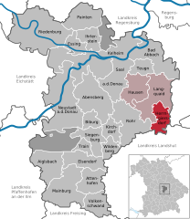
Роттенбург-на-Лабере (Rottenburg an der Laaber, Rottenburg an der Laaber)

 Hiking in Роттенбург-на-Лабере
Rottenburg an der Laaber is a charming town in Bavaria, Germany, that offers a variety of hiking opportunities in its surrounding landscapes. The region is known for its picturesque countryside, forested areas, and the scenic Laaber River, making it an excellent destination for hikers of all skill levels.
Hiking Trails
-
The Laaber Valley Trail (Laabertalweg): This trail runs alongside the Laaber River and provides beautiful views of the river and surrounding forests. It’s ideal for a leisurely hike and can be enjoyed by families and casual walkers.
-
Forest Trails: The area is rich in woodlands, with numerous forest trails where you can immerse yourself in nature. Look for marked paths that lead through dense trees and offer chances to spot local wildlife.
-
Hilltop Views: For those looking for a bit of elevation, hikes towards the nearby hills can provide spectacular views of the region. These trails may be more challenging but reward climbers with panoramic vistas.
Hiking Tips
-
Maps and Signage: Make sure to acquire a detailed hiking map of the area or download a GPS-enabled app. Most trails are well-marked, but having a map can help you navigate less-trafficked paths.
-
Appropriate Gear: Dress in layers, wear sturdy hiking boots, and carry enough water and snacks. Depending on the season, be prepared for varying weather conditions.
-
Local Insights: Engage with local hiking groups or guides, if possible. They can often provide insider tips on hidden trails or the best times to hike.
-
Respect Nature: Stick to designated trails, avoid littering, and observe local flora and fauna. This helps maintain the natural beauty of the area for future hikers.
Accessibility
Rottenburg an der Laaber is accessible by public transportation, making it a convenient spot for day trips from larger cities. Facilities like cafes and inns provide spots to rest and enjoy local Bavarian cuisine after a day of hiking.
Conclusion
Whether you’re looking for a challenging hike, a scenic stroll, or a family-friendly outing, the trails around Rottenburg an der Laaber offer something for everyone. Enjoy your hiking adventures in this beautiful part of Bavaria!
- Страна:

- Почтовый код: 84056
- Телефонный код: 08781
- Координаты: 48° 42' 7" N, 12° 1' 38" E


- GPS треки (wikiloc): [Ссылка]
- Высота над уровнем моря: 453 м m
- Площадь: 90.11 кв.км
- Население: 7827
- Веб сайт: https://www.rottenburg-laaber.de/
- Википедия русская: wiki(ru)
- Википедия английская: wiki(en)
- Википедия национальная: wiki(de)
- Хранилище Wikidata: Wikidata: Q170243
- Катеория в википедии: [Ссылка]
- код Freebase: [/m/0fgvvy]
- код GeoNames: Альт: [2843728]
- код VIAF: Альт: [135337211]
- ID отношения в OpenStreetMap: [179380]
- код GND: Альт: [4050730-0]
- идентификатор местоположения ArchINFORM: [13606]
- место в MusicBrainz: [912172bd-72f1-4c55-b123-741ad697d81e]
- код Historical Gazetteer: [ROTBERJN68AQ]
- Bavarikon ID: [ODB_A00001534]
- идентификатор муниципалитетов в Германии: 09274176
Граничит с регионами:

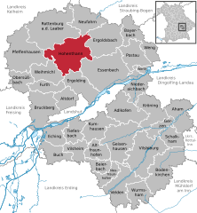
Хернгирсдорф
Hiking in Хернгирсдорф
Herrngiersdorf is a small village located in Bavaria, Germany, and it offers a wonderful experience for hiking enthusiasts. While it may not be as renowned as other hiking destinations, its surrounding landscapes provide charming trails and a glimpse into the scenic beauty of the Bavarian countryside....
- Страна:
- Почтовый код: 84097
- Телефонный код: 09452
- Код автомобильного номера: KEH
- Координаты: 48° 48' 0" N, 12° 4' 0" E
- GPS треки (wikiloc): [Ссылка]
- Высота над уровнем моря: 405 м m
- Площадь: 25.08 кв.км
- Население: 1010
- Веб сайт: [Ссылка]


Ширлинг
Hiking in Ширлинг
Schierling, located in Bavaria, Germany, is a charming area that offers a variety of hiking opportunities. Nestled in the picturesque countryside near the Regen River, it features a mix of scenic landscapes, rolling hills, and lush forests. Here are some highlights and tips for hiking in Schierling:...
- Страна:
- Почтовый код: 84069
- Телефонный код: 09451
- Код автомобильного номера: R
- Координаты: 48° 50' 5" N, 12° 8' 23" E
- GPS треки (wikiloc): [Ссылка]
- Высота над уровнем моря: 381 м m
- Площадь: 77.42 кв.км
- Население: 6322
- Веб сайт: [Ссылка]
Хоэнтанн
Hiking in Хоэнтанн
Hohenthann, located in Bavaria, Germany, offers scenic hiking opportunities amidst beautiful natural landscapes. While the specific trails can vary in difficulty, Hohenthann is known for its pleasant countryside, rolling hills, and charming rural scenery....
- Страна:
- Почтовый код: 84098
- Телефонный код: 08784
- Код автомобильного номера: LA
- Координаты: 48° 40' 0" N, 12° 6' 0" E
- GPS треки (wikiloc): [Ссылка]
- Высота над уровнем моря: 487 м m
- Площадь: 68.24 кв.км
- Население: 2661
- Веб сайт: [Ссылка]


Пфеффенхаузен
Hiking in Пфеффенхаузен
Pfeffenhausen is a charming town located in Bavaria, Germany, which offers a variety of scenic landscapes and hiking opportunities. Whether you're a beginner or an experienced hiker, there are trails and routes suited for different skill levels. Here are some key points to consider when hiking in and around Pfeffenhausen:...
- Страна:
- Почтовый код: 84076
- Телефонный код: 08782
- Код автомобильного номера: LA
- Координаты: 48° 40' 0" N, 11° 58' 0" E
- GPS треки (wikiloc): [Ссылка]
- Высота над уровнем моря: 436 м m
- Площадь: 71.76 кв.км
- Население: 4179
- Веб сайт: [Ссылка]
Нойфарн
Hiking in Нойфарн
Neufahrn in Niederbayern is a charming village located in the Lower Bavaria region of Germany. While it may not be as widely known for its hiking trails as some of the larger national parks or mountainous areas, there are still opportunities for outdoor enthusiasts to explore the beautiful landscapes of the region....
- Страна:
- Почтовый код: 84088
- Телефонный код: 08773
- Код автомобильного номера: LA
- Координаты: 48° 44' 0" N, 12° 11' 0" E
- GPS треки (wikiloc): [Ссылка]
- Высота над уровнем моря: 404 м m
- Площадь: 38.76 кв.км
- Население: 3133
- Веб сайт: [Ссылка]


Рор
- муниципалитет в Германии, Бавария
Hiking in Рор
Rohr in Niederbayern, located in the Lower Bavaria region of Germany, is surrounded by beautiful landscapes that are ideal for hiking. The area features a mix of scenic forests, rolling hills, and charming villages, making it a great destination for outdoor enthusiasts....
- Страна:
- Почтовый код: 93352
- Телефонный код: 08783
- Код автомобильного номера: KEH
- Координаты: 48° 46' 0" N, 11° 58' 0" E
- GPS треки (wikiloc): [Ссылка]
- Высота над уровнем моря: 426 м m
- Площадь: 54.12 кв.км
- Население: 2956
- Веб сайт: [Ссылка]